This item has been sold, but you can get on the Waitlist to be notified if another example becomes available, or purchase a digital scan.
1941 U.S. Navy Map or Nautical Chart of the Pescadores (Penghu) Islands, Taiwan
Pescadores-usnavy-1941$37.50

Title
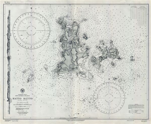
Japan Formosa Strait Pescadores Islands Hatta Retto (Rover Group).
1941 (dated) 24 x 30 in (60.96 x 76.2 cm) 1 : 19020
1941 (dated) 24 x 30 in (60.96 x 76.2 cm) 1 : 19020
Description
This is an uncommon 1941 World War II era map or nautical chart of Hatta-Retto or the Rover Group by the U.S. Navy Hydrographic Office. This chart covers the Islands of Pachau and Tsiang. Hatta-Retto or modern day Wang-an subdivision is part of the Pescadores or Penghu Islands located off the western coast of Taiwan or Formosa, in the Taiwan Strait. Based on Japanese surveys in 1896, with additions to 1941, this chart offers extraordinary detail throughout including topography. The map shows considerable inland detail for a nautical chart, noting buildings, towns, hills, etc. The chart includes countless depth soundings in fathoms as well as notes on currents and other practical information for the mariner. An elevation profile is included along the left margin. First issued in 1912, the map, in this state, has been updated to 1941. Issued as chart no. 2641 by the U.S. Navy at the Hydrographic Office under the authority of the Secretary of the Navy.
Cartographer
United States Hydrographic Office (1866 - 1962) was a brach of he U.S. Navy that prepared and published maps, charts, and nautical books to aid in navigation. Before the establishment of the Hydrographic Office in 1866, U.S. navigators were almost entirely dependent on British charts. There had been a few private enterprises that had prepared and published charts, but none had been able to do so profitably. The Office was established 'for the improvement of the means of navigating safely the vessels of the Navy and of the mercantile marine, by providing, under the authority of the Secretary of the Navy, accurate and cheap nautical charts, sailing directions, navigators, and manuals of instructions for the use of all vessels of the United States, and for the benefit and use of navigators generally.' This way the Navy Department could furnish navy and merchant ships with charts illustrating the results of surveys and explorations undertaken by naval officers. The charts were priced to cover the cost of paper and printing alone, not preparation. Its main objective was to survey foreign coasts, as the Coast and Geodetic Surveys were responsible for surveying domestic waters. The Hydrographic Office was transferred from the Department of the Navy to the Department of Defense in 1949 and was replaced by the Naval Oceanographic Office in 1962. More by this mapmaker...
Condition
Very good. Minor wear along Original fold line.