This item has been sold, but you can get on the Waitlist to be notified if another example becomes available, or purchase a digital scan.
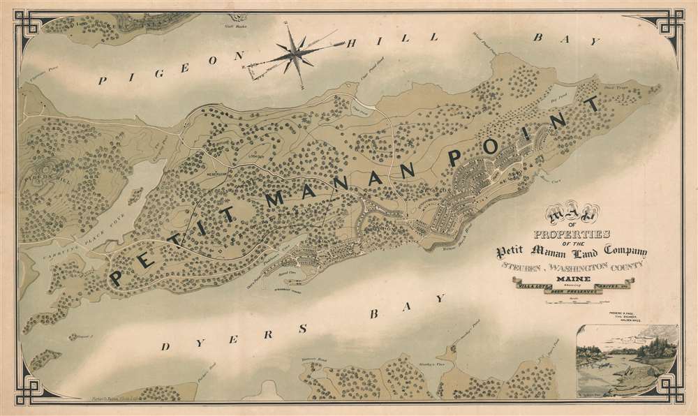
1889 Page Promotional Map of Petit Manan (near Mount Desert, Steuben, Maine)
PetitMananMaine-page-1889$750.00

Title
Map of Properties of the Petit Manan Land Company, Steuben, Washington County, Maine
1889 (undated) 20.5 x 34.5 in (52.07 x 87.63 cm) 1 : 8600
1889 (undated) 20.5 x 34.5 in (52.07 x 87.63 cm) 1 : 8600
Description
This is a rare c. 1889 broadside chromolithograph map of Petit Manan, Steuben, Maine, promoting the development of a new resort community 12 miles east of Mount Desert Island. The map was part of an effort to capitalize on the explosion of 'Rusticator' tourism to Mount Desert Island - most of which centered on the port of Bar Harbor. Petit Manan is a finger of forested land projecting into the sea between Dyers Bay and Pigeon Hill Bay, just east of Bar Harbor. The map looks eastward on the fledgling development, with north at the left side of the map. It notes proposed streets, lots for sale, the sites of future hotels, and a large deer preserve.
The Petit Manan Land Company
The Petit Manan Land Company was the brainchild of S. K. Abbott, a businessman from Boston. Abbott is surprisingly elusive, but is most likely Sylvester Kinsman Abbott, a bookbinder by trade, but apparently quite wealthy judging from his monumental gravestone in Malden.The Boston Globe (June 16, 1889) wrote of the Petit Manan development project,Petit Manan has decided advantages over the other summer resorts along the coast of Maine. Nature is there seen at its best; flung well out at sea. There are points on its pine-clad ridges where the spray is sent over the treetops where there is a storm on the ocean. While the land view is all that can be obtained at any other point, the sea scope is grand. Nowhere else is so broad a view obtained. Landward distant hills can be seen, their outline softened into dimness. Close at hand, at the mouth of Narraganagus Bay, is the island of Bois Rupurt, its crinkled crest bristling with pines and spruce, its surf-smitten reefs forever appearing and disappearing the waves of foam. Looking southward, one sees the glorious Atlantic, to be seen, not described. The petit Manan Island lighthouse, 109 feet above its base of lonely rocks, flashes out its light above the waves, and west the great mountains that glorify Bar Harbor stand out against, if not above, the clouds.The development began under Abbott in 1899 and continued under his successors (he died in 1890). Petit Manan was scheduled to open in June of 1896, by which time the major access roads still in use today were completed, if little else. In the subsequent decades, despite its beautiful location, earnest promotion, and ambitious dreams, Petit Manan Point was unable to draw either 'rusticators' or wealthy urbanites in search of a summer home. Abbott himself died shortly thereafter in 1900, leaving the property to a consortium of investors. In 1902, having failed to attract buyers, the Petit Manan Land Company sold the property to the Main Coast Club, which promptly erected a clubhouse, casino, and cottages - and stocked the deer park. But this effort too, failed. By 1910, only a church and a few cottages had been constructed. Nonetheless, investors continued to promote the resort for another 20 years. In 1975, the land was owned by Mr. and Mrs. William Mague, who transferred it to the state to become the Petit Manan National Wildlife Refuge. Today, Petit Manan Point is part of the Maine Coastal Island National Wildlife Refuge.
Chromolithography
Chromolithography is a color lithographic technique developed in the mid-19th century. The process involved using multiple lithographic stones, one for each color, to yield a rich composite effect. Oftentimes, the process would start with a black basecoat upon which subsequent colors were layered. Some chromolithographs used 30 or more separate lithographic stones to achieve the desired effect. Chromolithograph color could also be effectively blended for even more dramatic results. The process became extremely popular in the late 19th and early 20th centuries, when it emerged as the dominate method of color printing. The vivid color chromolithography produced made it exceptionally effective for advertising and propaganda imagery.Publication History and Census
This map was drawn by Frederic Roscoe Page and printed in Boston by the Forbes Photo. Lith. Company. It was published by Sylvester Kinsman Abbott on behalf of the Petit Manan Land Company. Examples are exceedingly rare. Examples are known at the Library of Congress and at Yale University.CartographerS
Frederic Roscoe Page (July 26, 1850 - 1998) was a civil engineer and land speculator active in Malden, Massachusetts in the late 19th century. Page was born in Concord, Massachusetts. Page had close ties to Maine where several of his family members were born. In the late 19th century, Page became involved with fellow Maldenite Sylvester Kinsman Abbott (1831 - 1890) the Petit Manan Land Company, a real-estate investment in Maine intended as a rival to Bar Harbor and Mount Desert Island. His death date is not known, but he was active as late as 1897 and his wife Alice Maud Mason Page (1863 - 1926) remarried in 1899, suggesting a death date of about 1898. More by this mapmaker...
Sylvester Kinsman Abbott (December 9, 1831 - June 14, 1890) was a Massachusetts based businessman, land speculator, and bookbinder active in the late 19th century. Abbott was born in Bedford, Massachusetts and lived most of his life in nearby Malden. In the late 19th century, he became involved in the Petit Manan Land Company, a real-estate investment in Maine intended as a rival to Bar Harbor and Mount Desert Island. The investment was already floundering when he died, but judging from his enormous, monumental tombstone at Forest Dale Cemetery in Malden, he was quite wealthy. Learn More...
William H. Forbes (1836 - February 3, 1915) was an English-American businessman and printer active in the second half of the 19th and early 20th centuries. Forbes was born in Liverpool England and immigrated to the United States at 12 years old. In the United States, he lived with Quaker relatives at Milton-on-the-Hudson, who provided him with a top-notch education. Forbes apprenticed as lithographer under H. A. Strong in New York. Following his maturity, he relocated to Boston in 1861, founding William H. Forbes and Company shortly after, in 1862. Forbes proved an excellent lithographer and savvy businessman. He reorganized his growing printing concern in 1875, incorporating as Forbes Lithograph Manufacturing Company in 1875. They focused on lithography, embossing, Albertype process printing, typesetting, copper and steel plate printing, and photolithography. At its height, Forbes Lithograph Manufacturing Company had over 70 presses located in Boston, New York, Chicago, and London, and staffed more than 600 workers, including 60 designers, artists, engravers, and lithograph artists. By 1881, Forbes himself had taken a back seat, working as the company treasurer, with William P. Hunt serving as president. In his personal life Forbes was well liked. He married the sister of well-known lithographer Louis Prang. After his death, the firm was taken over by his son, William S. Forbes. During World War II they were major printers of Allied military currency, producing more than 4 billion notes. The firm went out of business in the second half of the 20th century. Learn More...
Condition
Very good. Laid down on archival tissue.
References
OCLC 56466769.