
This item below is out of stock, but another example (left) is available. To view the available item, click "Details."
Details
1846 Mitchell Plan or Map of Philadelphia, Pennsylvania
1846 (dated) $250.00
1854 Mitchell Map of Philadelphia, Pennsylvania
Philadedlphia-mitchell-1854$100.00

Title
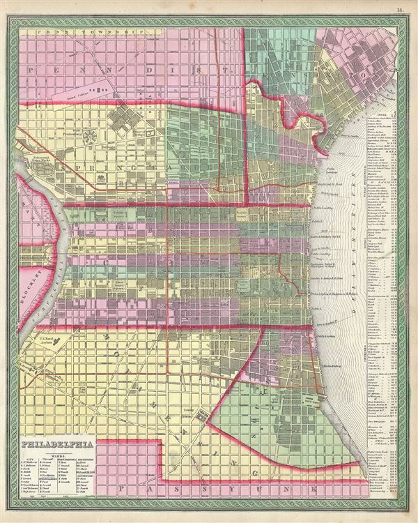
Philadelphia.
1854 (undated) 16 x 13 in (40.64 x 33.02 cm) 1 : 17000
1854 (undated) 16 x 13 in (40.64 x 33.02 cm) 1 : 17000
Description
This is a beautiful example of S. A. Mitchell Jr.'s 1854 map of Philadelphia, Pennsylvania. Depicts the city of Philadelphia along with parts Camden. Offers wonderful detail at the street level including references to the individual buildings, trains, canals, city wards and roads. Colored coded with pastels according to city wards. Nice detail in the Delaware River notes ferry crossings, sand bars, currents, and the steamboat routes. The whole is engraved in Mitchell's distinctive style with green border work and vivid pastels. A table to the right of the map proper, in the midst of the Delaware River, assigns Public Buildings, Hotels, Churches, and Banks numerical codes.
One of the more attractive atlas maps of Philadelphia to appear in the mid-19th century. This map was prepared by S. A. Mitchell for publication by the Philadelphia firm of Thomas Cowperthwait and Co. as plate no. 14 in the 1854 edition of Mitchell's New General Atlas.
One of the more attractive atlas maps of Philadelphia to appear in the mid-19th century. This map was prepared by S. A. Mitchell for publication by the Philadelphia firm of Thomas Cowperthwait and Co. as plate no. 14 in the 1854 edition of Mitchell's New General Atlas.
Cartographer
Samuel Augustus Mitchell (March 20, 1792 - December 20, 1868) began his map publishing career in the early 1830s. Mitchell was born in Bristol, Connecticut. He relocated to Philadelphia in 1821. Having worked as a school teacher and a geographical writer, Mitchell was frustrated with the low quality and inaccuracy of school texts of the period. His first maps were an attempt to rectify this problem. In the next 20 years Mitchell would become the most prominent American map publisher of the mid-19th century. Mitchell worked with prominent engravers J. H. Young, H. S. Tanner, and H. N. Burroughs before attaining the full copyright on his maps in 1847. In 1849 Mitchell either partnered with or sold his plates to Thomas, Cowperthwait and Company who continued to publish the Mitchell's Universal Atlas. By about 1856 most of the Mitchell plates and copyrights were acquired by Charles Desilver who continued to publish the maps, many with modified borders and color schemes, until Mitchell's son, Samuel Augustus Mitchell Junior, entered the picture. In 1859, S.A. Mitchell Jr. purchased most of the plates back from Desilver and introduced his own floral motif border. From 1860 on, he published his own editions of the New General Atlas. The younger Mitchell became as prominent as his father, publishing maps and atlases until 1887, when most of the copyrights were again sold and the Mitchell firm closed its doors for the final time. More by this mapmaker...
Source
Mitchell, S. A., A New Universal Atlas Containing Maps of the various Empires, Kingdoms, States and Republics Of The World, (Thomas Cowperthwait & Co., Philadelphia) 1854.
Condition
Very good. Overall age toning. Minor spotting at places.
References
Rumsey 0545.018. Phillips (Atlases) 814.