This item has been sold, but you can get on the Waitlist to be notified if another example becomes available, or purchase a digital scan.
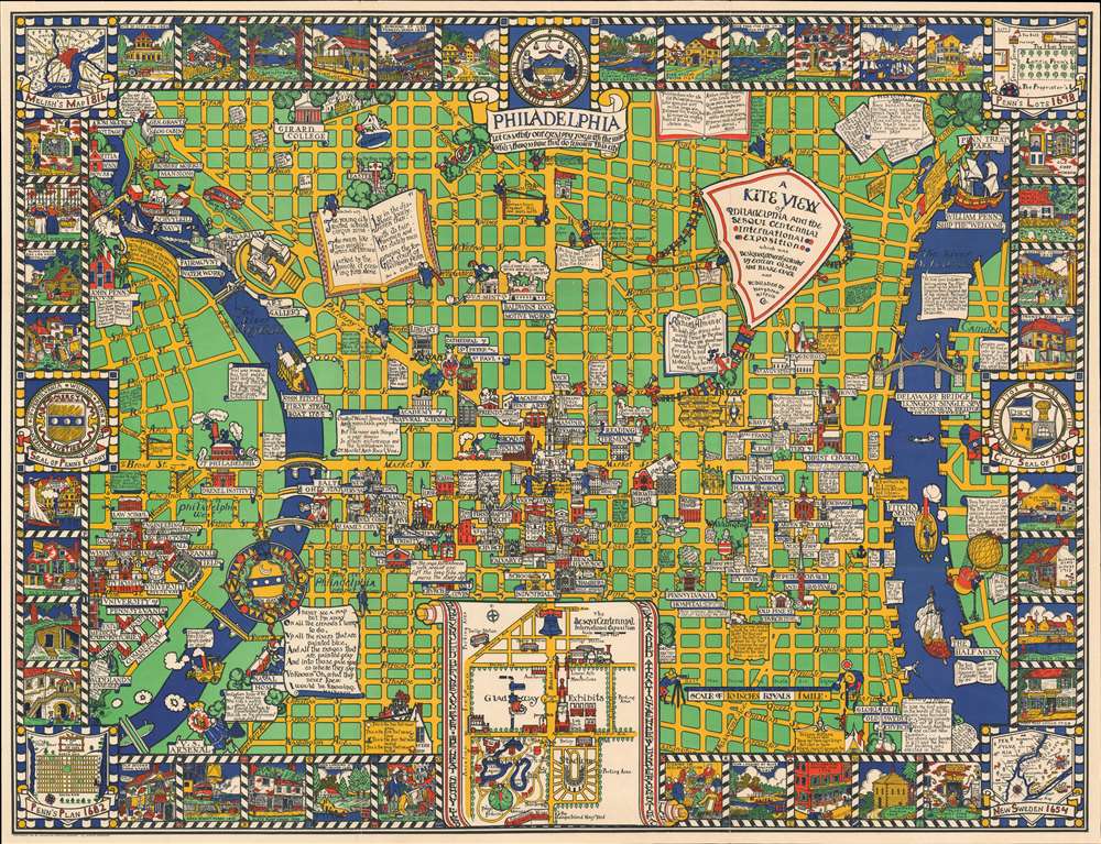
1929 Olsen and Clark Pictorial Map 'Kite View' of Philadelphia, Pennsylvania
PhiladelphiaKiteView-olsenclark-1926$600.00

Title
A Kite View of Philadelphia and the Sesqui Centennial International Exposition.
1926 (dated) 29.5 x 38.5 in (74.93 x 97.79 cm) 1 : 6300
1926 (dated) 29.5 x 38.5 in (74.93 x 97.79 cm) 1 : 6300
Description
This is Edwin Birger Olsen and Blake Everett Clark's 1926 pictorial map of Philadelphia, one of the first separately issued pictorial maps published in the United States. Centered historic downtown area, the map colorfully depicts Philadelphia from Gipard Avenue in the north, to Washington Avenue in the south, and between the University of Pennsylvania and the Delaware River.
Memorials and Things of Fame
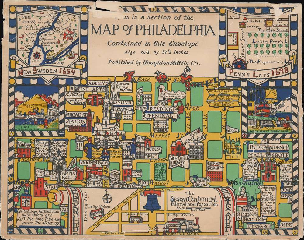
Stunningly illustrated, Olsen and Clark blend together all the best conventions associated with pictorial cartography. Numerous sites throughout the city are drawn in profile, including Independence Hall, Christ Church, Carpenter's Hall, the mercantile Library, Washington Square, Baldwin's Locomotive Works, and more. Several historic ships ply the rivers, including Henry Hudson's Half Moon, 'Fitche's Second Boat', William Penn's Welcome, and others. The border consists of vignettes of historical sites and events around the city, including the 'Old Watch Shop', the launch of the U.S.S. Pennsylvania, the High Street Prison, the Old Friend's Almshouse, the Friend's Meeting House, Chestnut Street, among many others. Historic maps of the area illustrate each corner. A large inset at bottom center, illustrates the site of the 1926 Sesqui-Centennial International Exposition.1923 Sesqui-Centennial International Exposition
The Sesqui-Centennial International Exposition of 1926 was a world's fair in Philadelphia, Pennsylvania. Its purpose was to celebrate the 150th anniversary of the signing of the United States Declaration of Independence, and the 50th anniversary of the 1876 Centennial Exposition. The fair opened on May 31, 1926, and ran through November. It was located on grounds bounded by 10th Street, Packer Avenue, 23rd Street, and the U.S. Navy Yard (Terminal Avenue) in South Philadelphia. Originally known as League Island Park, this area now contains multiple sports stadiums public recreation areas. Among the delights that greeted visitors in 1923 was an 80-foot replica of the Exposition's symbol, the Liberty Bell, covered in 26,000 lights. Despite this wonder, the fair was plagued by poor weather and did poorly, drawing a much smaller crowd than the anticipated 10,000,000. Variety dubbed it 'America's Greatest Flop.' With a loss of $20 million by August 1926, the exposition filed for bankruptcy in 1927, at which point its assets were sold at auction.Publication History and Census
This map was created by Edwin Birger Olsen and Blake Everett Clark and published by the Houghton Mifflin Company in 1926. It was released in conjunction with the 1923 Sesqui-Centennial International Exposition, a world's fair held in Philadelphia. The present example is accompanied by the map's original presentation envelope, which is, unfortunately, not in the same excellent condition as the map. The map is uncommon on the market, but represented in several institutional collections, including the Boston Public Library and David Rumsey's collection.CartographerS
Edwin Birger Olsen (1902 - 1996) was an American artist, draftsman, and architect and collaborated with Blake E. Clark on a series of pictorial city plans. Born in New York, Olsen graduated from Harvard in 1923 with a degree in architecture. He then continued his education at the Beaux-Arts Institute of Design in New York City. Olsen and his collaborator Blake Everett Clark (1900 - 1979) had an influential impact on the world of pictorial cartography. Olsen spent a short time teaching in Idaho architecture at the University of Idaho and it was during his time in Idaho that he began to formulate his ideas about pictorial cartography. In the an interview that appeared on page two of the Boston Evening Transcript on April 21, 1926, Olsen stated
On that trip, the idea. That had been buzzing in my head came to a resolution. If you visit a city and want really to taste its flavor, to feel its history and at the same time see it in its modern aspects, you have to take a few auto trips...Then you read eight or ten books and roam a little on your own. I wondered why a map - one map and not two or three supplemented by guidebooks and pamphlets-could not give what I was after, you know, the spirit, the color of a city. A map could be picturesque and yet informative, could avoid the stereotyped network of dull, straight lines, and still keep the city within bounds. Well, I thought it could be done, at least that the combination of Blake and myself...could do it.Olsen and Blake collaborated on three maps: The Colour of An Old City: A Map of Boston Decorative and Historical, A Kite View of Philadelphia and the Sesqui-Centennial International Exposition, and Map of the City of Washington in the District of Columbia shewing the Architecture and History from the most Ancient Times down the Present. After his time working with Clark on these three maps, Olsen worked for the architectural firms Eggers and Higgins, John Russell Pope, and McKim, Meade, and White and collaborated on such projects as the National Gallery of Art and Jaqueline Kennedy's restoration of the White House. More by this mapmaker...
Blake Everett Clark (June 22, 1900 - January 17, 1979) was an American artist. Born in Somerville, Massachusetts, the son of a stockbroker, Clark studied at Milton Academy (1917). ON graduation he went to France to serve in World War I (1914 - 1818) with the 301st Ambulance Detail Battery. On his return not the United States, he enrolled in Bowdoin College (1923), and Tufts College. He then moved to Paris where he studied art at the Académie Delécluse, Montparnasse. He returned to Boston by 1925, where he pursued a career in marine and landscape painting. During this time, he painted a second home in Ogunquit, Maine. While living in Boston, Clark collaborated with Edwin Birger Olsen (1902 - 1996) on a series of three pictorial maps: The Colour of An Old City: A Map of Boston Decorative and Historical (1926), A Kite View of Philadelphia and the Sesqui-Centennial International Exposition (1926), and Map of the City of Washington in the District of Columbia shewing the Architecture and History from the most Ancient Times down the Present (1926). He married Muriel Cooley in the 1930s, and settled in Brooklyn, New York, where he worked as an artist and a buyer at a department store. He disappears in subsequent decades, but reappears in Arizona in 1964, when he issued a pictorial map of that state, A New Mappe of Ye Old Arizona. He died in Maricopa, Arizona, in 1979. Learn More...
Condition
Very good. A few miner splits on old fold intersections - archivally reinforced on verso. Accompanies original envelope.
References
Boston Public Library, Leventhal Collection, G3824.P5A5 1926 .O47. Rumsey 7948.002.