This item has been sold, but you can get on the Waitlist to be notified if another example becomes available, or purchase a digital scan.
1852 Coello / Morata Case Map of the Philippines
Philipines1-morata-1852$300.00

Title
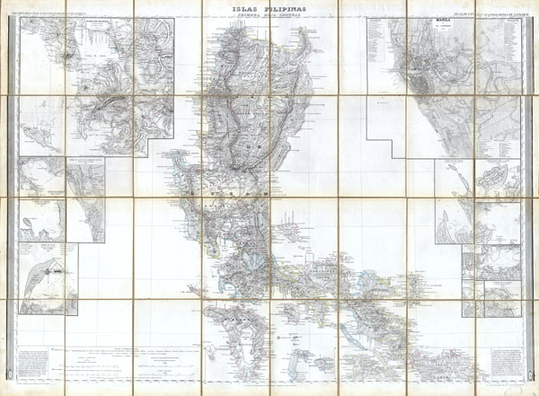
Islas Filipinas, Primera Hoja Central
1852 33 x 43 in (83.82 x 109.22 cm)
1852 33 x 43 in (83.82 x 109.22 cm)
Description
This magnificent 1852 hand colored case map of the Philippines was issued by Dr. Morata and Francisco Coello of Madrid. In 32 folding sections mounted onto linen. Covers the central Philippines including the island of Luzon (w/ Manila), the island of Samar, and the island of Mindoro. Features numerous insets including a very large and detailed street plan of Manila. Other inset maps include a large depiction of the greater Manila area, and numerous ports and rivers. Perhaps the finest and most detailed 19th century map of the Philippines ever published. Comes with original linen slip case and publisher's label. Note: This map was part of three map issue covering the entirety of the Philippines.
Cartographer
Francisco Coello de Portugal y Quesada (1822 - September 30, 1898) was a Spanish cartographer, explorer, and military engineer active in the mid-19th century. Coello was born in Jaen, Spain and joined the military in 1833, enrolling at the Special Army Corps of Engineers Academy of Guadalajara. Upon graduating with honors he joined Corps of Military Engineers where after serving in the First Carlist War, and later in Algeria, he attained the rank of Colonel. Coello later founded the Geographical Society of Madrid and served many years as its president. He was also a corresponding member of the American Geographical Society and a full member of the Real Sociedad Geográfica de España. Coello's greatest work, his monumental Atlas de España y sus posesiones de Ultramar, was truncated by his death in 1898 and consequently never completed. Nevertheless, the work is of historical significance as the first scientifically produced maps of Spain, Cuba, and Porto Rico. More by this mapmaker...
Condition
Fine or perfect condition with wide clean margins. Mounted on original linen.