This item has been sold, but you can get on the Waitlist to be notified if another example becomes available, or purchase a digital scan.
1945 U.S. Army Map of the Philippines and the Philippine Campaign
PhilippineCampaign-usarmy-1945-4$225.00

Title
Philippine Campaign.
1945 (dated) 22.25 x 16.5 in (56.515 x 41.91 cm) 1 : 2985000
1945 (dated) 22.25 x 16.5 in (56.515 x 41.91 cm) 1 : 2985000
Description
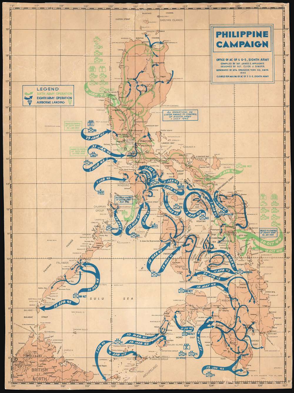
This is an unusual 1945 James E. Applegate and Clyde J. Singer thematic map of the Philippine Islands illustrating the events of the Philippine Campaign (1944 – 1945) during World War II. The map depicts the entirety of the Philippine archipelago with sinuous arrows indicating military activity. Blue arrows indicate operations undertaken by the Eighth Army, while green arrows highlights the operations of the Sixth Army, and little parachute drawings in either color represent airborne landing sites.
The Philippine Campaign
Launched on October 20, 1944, the Philippine Campaign was a joint American and Filipino military operation intended to liberate the Philippine Islands from occupying Imperial Japanese forces. The Japanese Army overran most of the Philippines during the first half of 1942 and occupied the country for the following 2 years. American General Douglas MacArthur began the campaign by announcing on Philippine radio 'This is the Voice of Freedom, General MacArthur speaking. People of the Philippines: I have returned.' The campaign progressed rapidly, driving the Japanese out of one island after another. Although by this time the Japanese were clearly losing the war, they gave no sign of capitulation and refused to surrender. During the campaign, Japan suffered nearly half a million casualties compared to only about 50,000 American casualties. The campaign continued until Japanese forces in the Philippines were ordered to surrender by Tokyo on August 15, 1945, after the dropping of atomic bombs on Hiroshima and Nagasaki.Publication History and Census
This map was compiled by Sgt. James E. Applegate, designed by Sgt. Clyde J. Singer, and printed by the 67th Engineer Topo Company, SWPA (South West Pacific Area) in 1945.Cartographer
Clyde Jacob Singer (October 20, 1908 - January 5, 1999) was an American muralist, teacher, painter, and etcher. Born in Malvern, Ohio, Singer enrolled in the art school at the Columbus Gallery of Fine Arts (now the Columbus Museum of Art) after high school and was soon directed into a career as an artist. He was awared a scholarship to attend the Art Students League in New York in 1933. Eventually he returned home to Ohio, where he again found a job painting signs, just as he had earlier in life. He sent a large canvas to the Chicago Art Institute in 1935 and won the Harris silver medal and $500. After this success, Singer entered numerous exhibitions, including the Whitney Museum Annual and the Corcoran Biennial. He accepted a job from Joseph Butler III to teach at the Butler Institute in 1940. He married Bernice Shimp, one of his former students, in 1941. He was drafted into the U.S. Army in 1942, worked as an artist for the Army, and served in the Philippines, New Guinea, and Japan before being discharged in 1945. Singer returned to the Butler Institute after the war. Over the course of his career, Singer produced over 3,000 works. More by this mapmaker...
Condition
Good. Backed on archival tissue for stability. Even overall toning. Blank on verso.