1944 Cut Rate Liquor Map of the Philippines, World War II
Philippines-cutrateliquor-1944$1,200.00

Title
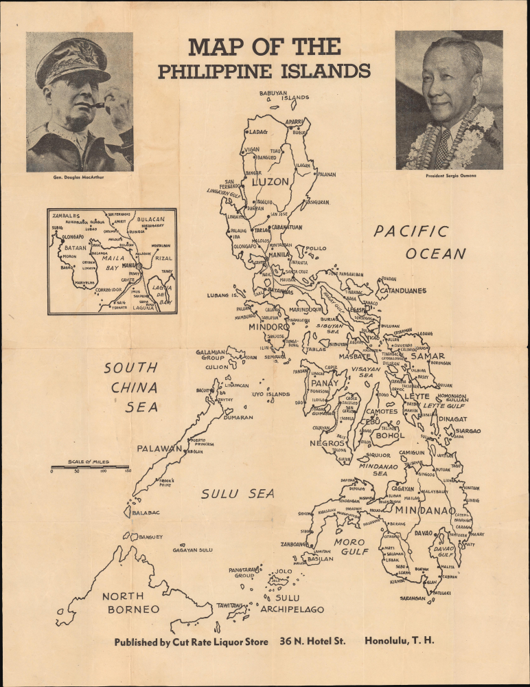
Map of the Philippine Islands.
1944 (undated) 22 x 17 in (55.88 x 43.18 cm) 1 : 3830000
1944 (undated) 22 x 17 in (55.88 x 43.18 cm) 1 : 3830000
Description
This is a rare 1944 map of the Philippine Islands published by the Cut Rate Liquor Store in Honolulu, Hawaii. It was produced in the context of the Philippines Campaign, the American-Filipino liberation of the islands from Japanese occupation.
A Closer Look
Coverage includes the Philippines, with the larger islands labeled, along with a portion of North Borneo (now part of Malaysia). Cities are labeled throughout, while railways and rivers are traced, and major lakes are outlined. An inset map at left displays Manila (typos 'Maila Bay,' 'Lagna de Bay'). At top are photographs of Gen. Douglas MacArthur, Supreme Commander of the Southwest Pacific Theater of Operations, and President of the Philippines Sergio Osmeña (who accompanied MacArthur during the landing on Leyte on October 20, 1944 and can be seen in the famous photograph of him wading ashore there).The Philippine Campaign
Launched on October 20, 1944, the Philippine Campaign was a World War II joint American and Filipino military operation intended to liberate the Philippine Islands from occupying Imperial Japanese forces. The Japanese Army overran most of the Philippines during the first half of 1942, retaining it for the subsequent 2 years. American General Douglas MacArthur began the campaign by announcing on Philippine radio 'This is the Voice of Freedom, General MacArthur speaking. People of the Philippines: I have returned.' The campaign progressed rapidly, driving the Japanese out of one island after another. Although by this time, the Japanese were clearly losing the war, they gave no sign of capitulation and refused to surrender. During the campaign, Japan suffered nearly half a million casualties, compared to only about 50,000 Americans and an unknown number of Filipino guerilla fighters, and surviving Japanese troops suffered from widespread hunger and disease. The civilian toll of the campaign was also significant, especially in the brutal battle for Manila in February and early March 1945, when some 100,000 civilians died, largely from atrocities committed by Japanese troops. The campaign continued until Japanese forces in the Philippines were ordered to surrender by Tokyo on August 15, 1945, after the dropping of atomic bombs on Hiroshima and Nagasaki.Publication History and Census
This ephemeral map was produced by the Cut Rate Liquor Store in Honolulu, Hawaii (Hawaii was the major jumping-off point for U.S. military operations in the Pacific and also home to tens of thousands of Filipino-born migrant workers). It is undated but almost certainly was published in late 1944 or perhaps early 1945 in the context of the Philippines Campaign, and in any event, must postdate the death of Manuel L. Quezon on August 1, 1944, and the ascension of Vice President Sergio Osmeña to the presidency. This is a very rare map; we are only aware of one other example, in the collection of Peter Geldart, featured in the August 2020 special World War II Issue of the The Murillo Bulletin: Journal of PHIMCOS, the Philippine Map Collectors Society.Condition
Very good. Some toning and offsetting. Wear on old fold lines. A few verso repairs to minor edge tears.
References
The Murillo Bulletin: Journal of PHIMCOS, the Philippine Map Collectors Society (August 2020), p. 21.