1900 Greely Map of the Philippines and Military Telegraph Lines and Cables
Philippines-greely-1900-2$900.00

Title
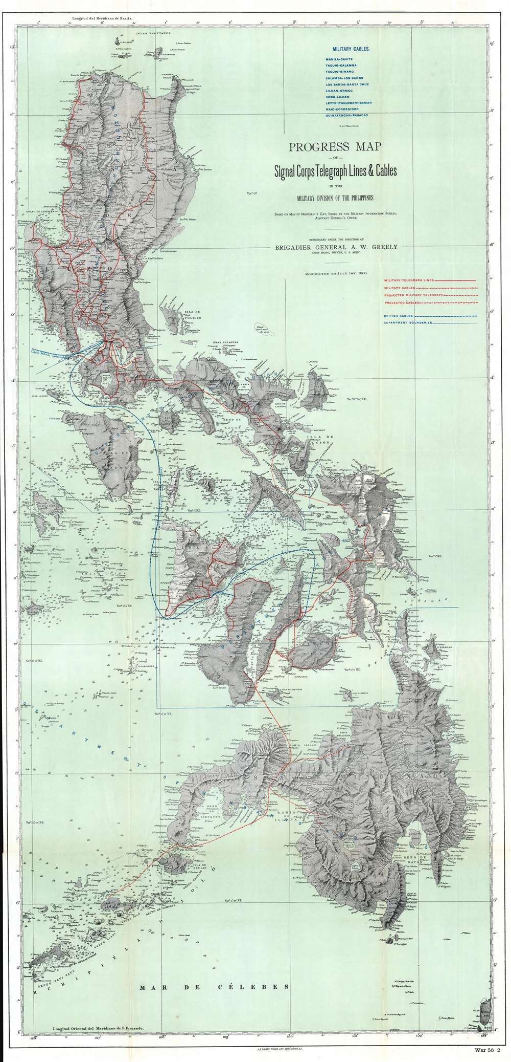
Progress Map of Signal Corps Telegraph Lines and Cables in the Military Division of the Philippines.
1900 (dated) 42.5 x 20.5 in (107.95 x 52.07 cm) 1 : 900000
1900 (dated) 42.5 x 20.5 in (107.95 x 52.07 cm) 1 : 900000
Description
This is a scarce 1900 map of the Philippines prepared under the direction of General Adolphus Washington Greely. This map represents a major step forward in Philippine infrastructure. The map is large and comprehensive, extending from the Babuyan Islands to the Sulu Archipelago, encompassing most of the modern-day Philippines except for Palawan. Cartographically, it is derived from the 1870 work of Claudio Montero y Gay. The map exhibits limited depth soundings throughout, but particularly between major island groups. American telegraphic cables, both extent and projected, are highlighted in red, while British lines appear in blue.
Brigadier General Adolphus Washington Greely
When this map was issued, Greely was the chief of the U.S. Army Signal Corps, in charge of constructing telegraph cables throughout U.S. Territories. In the Philippines, units under Greely's command laid over 10,000 miles of telegraph cable. Combined with existing British submarine lines, the telegraph cables laid under Greely's tenure provided the Philippines Islands' first comprehensive communication network.The Philippine-American War
The Philippine-American War lasted from February 4, 1899, until July 2, 1902, when the Philippine Organic Act established the Second Philippine Commission and Philippine legislature. The war immediately followed the Spanish-American War, once Filipinos realized, to their chagrin, that the Americans were in the islands to stay. Estimates of Filipino civilian casualties vary wildly, from at least 200,000 to over one million, the majority of which were caused by famine and disease. Armed resistance to the U.S. occupation of the Philippines continued as a guerrilla insurrection in many parts of the archipelago until June 1913. The U.S. passed the Tydings-McDuffie Act, also known as the Philippine Independence Act, in 1934. This law created the Commonwealth of the Philippines, increased self-governance, and scheduled Philippine independence for 1944. World War II delayed this process, and the U.S. did not grant full independence to the Philippines until 1946.Publication History and Census
This map was created under the direction of Brigadier General Adolphus Washington Greely and printed in Washington D.C. by the A. B. Graham Photo Lithography Corporation in 1900. Nine examples are cataloged in OCLC and are part of the institutional collections at Brown University, Cornell University, the Boston Athenaeum, Pennsylvania State University, the University of Michigan, Ball State University, the University of South Carolina, the University of California Los Angeles, and Stanford University.Cartographer
Andrew B. Graham (1845 - September 9, 1909) was an American lithographer active in Washington, D.C. in late 19th and early 20th century. Graham was born in Washington D.C., the son of a lithographer and engraver. After college, he joined the U.S. Coast Survey, where he was a draftsman until 1889. He retired from the Coast Survey to take over management of his father's lithography firm. The firm, Andrew B. Graham Company, was one of several that thrived on lucrative government publication contracts. Graham died of 'brain fever' in his Washington D. C. residence on September 9 of 1909. Some of his work was republished posthumously until about 1917, and his firm was active until at least the early 1920s. More by this mapmaker...
Condition
Very good. Exhibits light wear and toning along original fold lines. Close left margin. Blank on verso.
References
OCLC 35065162.