This item has been sold, but you can get on the Waitlist to be notified if another example becomes available, or purchase a digital scan.
1941 Wisner and Minneapolis Morning Tribune Map of the Philippines
Philippines-harrison-1941$100.00

Title
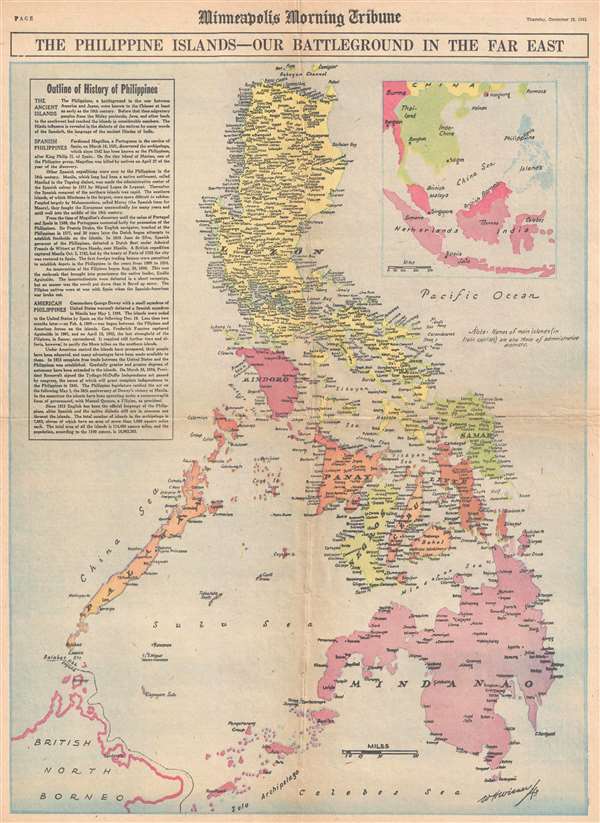
The Philippine Islands - Our Battleground in the Far East.
1941 (dated) 22 x 16 in (55.88 x 40.64 cm) 1 : 3140000
1941 (dated) 22 x 16 in (55.88 x 40.64 cm) 1 : 3140000
Description
This is a Thursday, December 18, 1941, W. H. Wisner and Minneapolis Morning Tribune map of the Philippines. Printed eight days after the first Japanese landing on Luzon, this map depicts the Philippine Archipelago from Babuyan Channel to the Sulu Archipelago and the Celebes Sea and from Borneo, Palawan, and the China Sea to the Pacific Ocean. Curiously, other than the headline and the first line of the text box along the left border, no other reference is made to the fighting on Luzon between American soldiers and Japanese forces. A highly detailed map, myriad locations throughout the islands are labeled, including Manila. Each of the island is labeled, along with several seas within the archipelago. A text box, entitled 'Outline of History of Philippines' provides readers with a history of the archipelago from the 10th century until 1940. An inset map, situated in the upper right corner, illustrates the Philippines in relation to other countries in the region, such as Indonesia (Dutch India), China, and Taiwan (Formosa).
This map was drawn by W. Harrison and printed by the Minneapolis Morning Tribune on Thursday, December 18, 1941.
This map was drawn by W. Harrison and printed by the Minneapolis Morning Tribune on Thursday, December 18, 1941.
CartographerS
William H. Wisner (1894 - December 11, 1963) was the manager of the editorial art department of The Chicago Tribune. Born in Brooklyn, Wisner attended Columbia University and the College of the City of New York. He then attended the Julian academy in Paris where he received his formal art training. He began working for the Tribune in 1913, but left the newspaper during World War I to serve as an attache to the inter-allied mission for propaganda. He rejoined the Tribune in 1919 as head of its editorial art department. Wisner held several posts over the course of his career with the Tribune, including several influential and revolutionary positions concerning the integration of photography into the newspaper. His greatest work, though, was 'when he devoted himself entirely to the complicated task of preparing full-color maps which provided Tribune readers with up-to-the-minute developments on the global battlefronts.' In 1948, Wisner resumed full management of the editorial art department and held that position until his retirement in January 1963. More by this mapmaker...
The Minneapolis Tribune (1867 - present) was founded by Colonel William S. King, William D. Washburn, and Dorilus Morrison and the first issue was published on May 25, 1867. In 1941, the Cowles family of Des Moines, Iowa bought the Tribune and merged it with their other holdings in Minneapolis, giving the Cowles family ownership of all the city's major newspapers. The Tribune became the city's morning newspaper, and the Star-Journal was the evening newspaper. The two published a joint Sunday edition. The newspaper is still published today, under the name Star Tribune. Learn More...
Condition
Very good. Newsprint. Even overall toning. Minor closed margin tear professionally repaired on verso. Text on verso.