This item has been sold, but you can get on the Waitlist to be notified if another example becomes available, or purchase a digital scan.
1943 Japanese Map of the Philippines
Philippines2-coprosperity-1943$275.00

Title
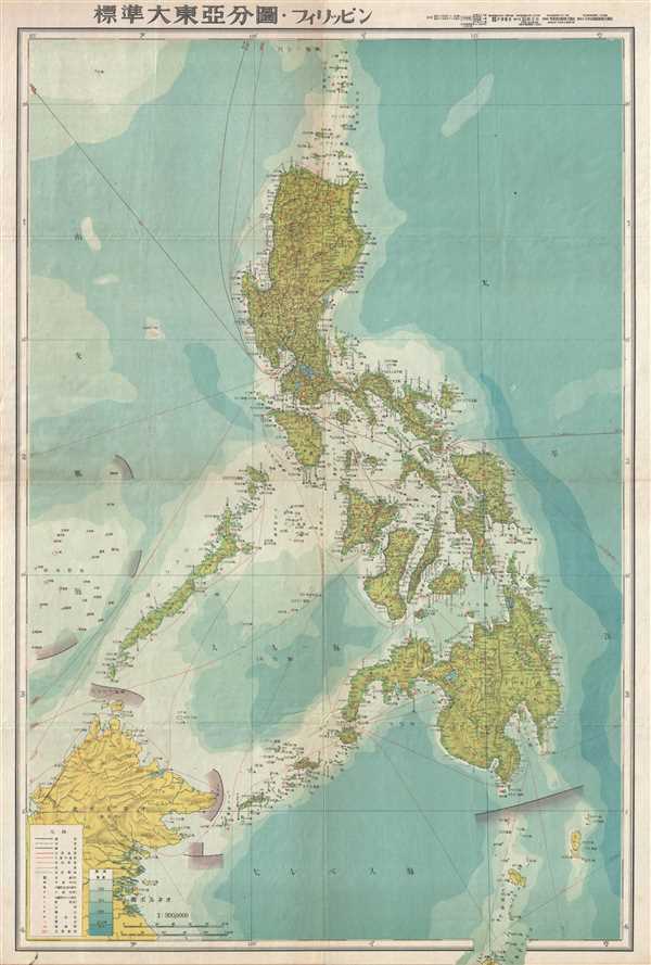
標準大東亞分圖 : フィリッピン / Standard Map of the Great East Asia: Philippines.
1943 (dated) 30 x 20 in (76.2 x 50.8 cm) 1 : 3000000
1943 (dated) 30 x 20 in (76.2 x 50.8 cm) 1 : 3000000
Description
An important and rare World War II (WWII) 1943 Japanese map of the Philippines. The map covers the Philippine Islands from the small islands north of the Luzon to North Maluku, which appears just outside the printed border, and from northern Borneo to the Philippine Sea. Oceanic depths are illustrated with blue shading. Air and sea routes are identified with distances noted. An important and rare World War II (WWII) 1943 Japanese map of the Philippines. Oceanic depths are illustrated with blue shading. Air and sea routes are identified with distances noted.
The capture and control of the Philippines was vital to the success of Japanese plan to dominate the Pacific. Not only was the archipelago rich in natural resources, including rubber, oil, mineral resources, and wood, it was also centrally located and well positioned for expansion into the West Indies. Moreover, wresting control of the Philippines from the United States would have effectively undermined the American ability to wage war in the region. The Japanese, like the Spanish before them, quickly discovered that the hundreds of islands and limited infrastructure made the Philippines almost impossible to fully control. Nonetheless, the importance of the Philippines in the Japanese plan is evident in the fact that map is no. 3 in the series, following only the general map of the Co-Prosperity Sphere and East Indian Archipelago map.
This the rarest map from the 20-map series Greater East Asian Co-Prosperity Sphere which was issued a between 1942 and 1944. There are at least two states of this map, the present example, and another, later edition, that includes an inset of Manila. The Co-Prosperity Sphere map series as published by the Japan Publishing and Distribution Company, Ltd. (日本出版配給株式會社).
Condition
Very good. Light wear and toning along original fold lines. Blank on verso. Accompanied by original sleeve.
References
OCLC 64055637.