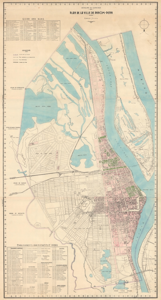
1935 Service Géographique de l'Indochine Wall Map of Phnom Penh, Cambodia
PhnomPenh-servicegeographique-1935
Title
1935 (undated) 52.5 x 28.25 in (133.35 x 71.755 cm) 1 : 10000
Description
A Closer Look
The map covers Phnom-Penh from the Mekong to the city limits and the borders of Kandal province. It is the product of a meticulous survey where even individual buildings are clearly illustrated. A host of new neighborhoods, civil projects, and grand boulevards are ghosted in - suggesting that these, most of which were realized by the late 1930s, were still under development. Among these is the current site of Orussey Market, here labeled 'Reserve pour Marche'. This map features primarily Khmer placenames, a sharp contrast to comparable commercial maps of the same period. For example, the prominent Avenues Verneville and Piquet are here identified as Rukhak Vithei Preah Mona Ksat Trianei Kossomak (Preah Moha Ksatreiyani Kossamak, 106) and Rukhak Vithei Okhna Phlong (Oknha Ing Bun Hoaw, 108).While undated, the mapping of the Phnom Penh - Poipet Railway, here terminating at a large central station, gives us a terminus post quem of 1932, and the various projected but incomplete developments a terminus ad quem of 1938.
The map bears a pencil annotation in the lower right that reads, 'Huot-Luon S.G.K.' This was likely the former owner, probably an official with the Service Géographique Khmer (1959 - present).
'Belle Epoque' of Phnom-Penh
Phnom-Penh was established as the capital of Cambodia in 1865 by King Norodom I (1860 - 1904). At the time, it was a waterlogged flood plain described by the 19th-century historian Penny Edwards asbest known for its vast tracts of mosquito-infested swampland, the stench of stagnant water and human waste, and frequent outbreaks of cholera.The French established a protectorate in Cambodia in the 1870s and began to remake the city as a grand colonial capital in the spirit of Saigon or Hanoi. Land reclamation efforts along the Tonle Sap River led to the construction of a Grand Canal, located roughly between avenues 106 (Avenue Verneville) and 108 (Avenue Piquet). This was followed by a railroad in the 1920s and the dredging and gridding of the region to the south of 108th Avenue (Avenue Piquet). The Grand Canal was filled and replaced with broad avenues and a park (Freedom Park) in the 1920s. The Phnom-Penh Railway Station - shown here as no. 18 - was completed in 1932 at the western end of Freedom Park. Likewise, the impressive Psar Themy or New Market (no. 85), completed in 1935, was built in a grandiose domed style using a then innovative material - reinforced concrete. The Japanese invaded Cambodia in 1941, stationing troops in Phnom-Penh, ending the French Era. At the end of WWII (1939 - 1945), King Norodom Sihanouk declared the independent Kingdom of Kampuchea. However, it took another 8 years before the French colonial administrators recognized the claim.
Publication History and Census
This map features no imprint or date, though we can loosely assign a timeframe based on the ephemeral content. Given the precision and detail, it was likely produced by the Service Géographique de l'Indochine out of Saigon. This is the only known example.Cartographer
Service Géographique de l'Indochine (1899 - c. 1954) was created by decree on July 5, 1899. A Lieutenant Colonel Lubanski, from the Service Géographique de l'Armée, was put in charge. He along with several other army officers, as well as trained topographers and other geographers, immediately began applying the cutting-edge scientific practices employed by the Service Géographique de l'Armée in France to Indochina. They were tasked with creating detailed new maps of the colony. The Service Géographique immediately began mapping the Tonkin and Than-hoa deltas in extreme detail, and published annually a report on their progress. As for the rest of the country, which was sparsely populated and frequently inaccessible jungle, much less detailed maps were deemed sufficient. The Service Géographique also published an Atlas of Indochina annually from 1920 until at least 1932, as well as a summary of their work, which was published annually from 1900. Although the historical record is unclear, it is likely that the Service Géographique was disbanded during the Japanese occupation of Indochina during World War II and reconstituted after the Japanese defeat. During the 1950s the Service Géographique benefited from aerial photography. More by this mapmaker...


