This item has been sold, but you can get on the Waitlist to be notified if another example becomes available, or purchase a digital scan.
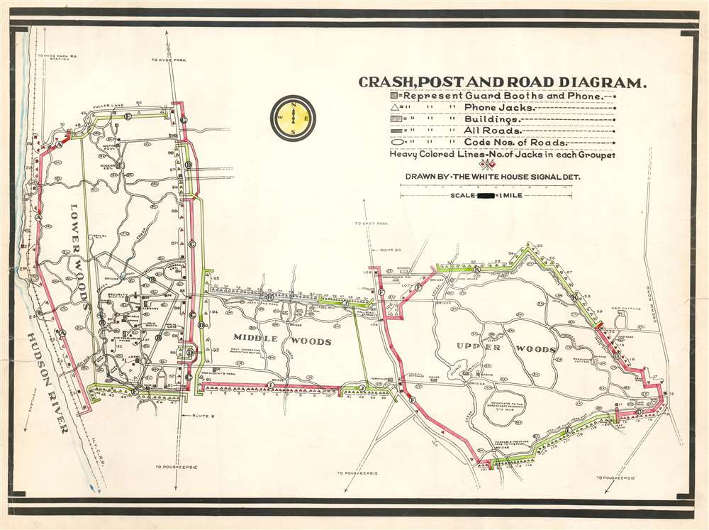
1945 White House Signal Detachment Map of the Phone Network at Hyde Park, NY
PhoneDiagramHydePark-whitehouse-1945$1,250.00

Title
Crash, Post and Road Diagram.
1945 (undated) 14.25 x 19.25 in (36.195 x 48.895 cm) 1 : 31680
1945 (undated) 14.25 x 19.25 in (36.195 x 48.895 cm) 1 : 31680
Description
This is a c. 1945 White House Signal Detachment map of the phone network at Hyde Park, New York near the end of President Franklin D. Roosevelt's final term as President of the United States. The map depicts the Springwood estate from the Hudson River to Cream Road and from Fuller Lane to just south of the estate. The estate is divided into three sections: lower woods, middle woods, and upper woods. Roads in each section are labeled numerically with an 'L', 'M', or 'X' to identify the part of the estate in which it is located, and roads that are only passable by jeep are labeled as such. Solid colored lines shaded red, green, and gray immediately jump out at the viewer, with each section labeled by a capital letter. It is unclear exactly what each section denotes. One possibility is that each letter marks a different telephone switchboard, since each of the small triangles marks a phone jack. These may also mark patrol routes, owing to the fact that the map is accompanied by two sheets of Secret Service code names, and the phone jacks mark points where agents on patrol could report back. Several buildings around the estate are labeled, including the President's House, the security building, the library, the Morgan Estate, the Rogers Estate, the J.R. Estate, Valkill Cottage, and the President's Cottage.
The Estate
Springwood, now the Home of Franklin D. Roosevelt National Historic Site, was bought by Franklin D. Roosevelt's father, James Roosevelt, in 1866. President Roosevelt was born, lived, and is buried here, and th4e estate played a critical role in his life both before and during his presidency. After Roosevelt married Eleanor in 1905, the young couple lived there as well with his mother. The estate functioned as 'the Summer White House' during his presidency, and Roosevelt made nearly 200 visits between his inauguration on March 4, 1933 and his death on April 12, 1945. The National Historic Site was established in 1945 after Roosevelt's death.Code Sheets
Two code sheets accompany the map. One sheet lists the numerical code for locations all across the estate and further afield. It also lists the codes for the highways and special calls, such as 'be on alert' and 'return to main booth'. An index of miscellaneous names is also included on this sheet and provides the codenames for the President (Alex), Mrs. Roosevelt (Ruth), and Harry Hopkins, Roosevelt's closest advisor, listed here as Mr. Hopkins (Raines). The second sheet lists the checkpoints and signals along the route from Washington, D.C. to Highland, New York, along with the symbols for approaching, passing, stopping at, and leaving a checkpoint, codenames for stations, and how to code mileage. The distribution of this second sheet is also noted at the bottom of the page, stating that one copy will be at each station listed, eight will be given to the U.S. Secret Service, and one more will be put in the Secret File. Both code sheets are dated March 1945.Publication History and Census
This map was created by the White House Signal Detachment c. 1945. The only other known example is part of the collection at the F.D.R. Historic Site.Condition
Very good. Exhibits some crackling. Closed tear extending one inch into printed area from left margin professionally repaired on verso. Blank on verso. Accompanied by two (2) laminated Secret Service code sheets.

