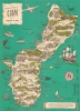
1958 Nelson Pictorial Map of Guam, Marianas Islands
PictorialGuam-nelson-1958-2$275.00


Title
The Historical Island of Guam of the Marianas Islands.
1958 (undated) 21.75 x 16 in (55.245 x 40.64 cm) 1 : 88900
1958 (undated) 21.75 x 16 in (55.245 x 40.64 cm) 1 : 88900
Description
This is a c. 1958 Bruce N. Nelson pictorial map of Guam, the southernmost of the Marianas Islands. While generally lighthearted, it reflects the deep imprint left by World War II (1939 - 1945) and the resulting increased presence of the U.S. military.
A Closer Look
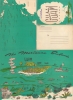
Depicting the entirety of the island, vignettes highlight historical events from Magellan's 1521 discovery of the island to the construction of modern roads. A sailing canoe, situated in the lower right just above a short text on the history of Guam, illustrates the ancient Chamorros (the indigenous people of the Marianas Islands) exploring the Pacific. More recent history is also illustrated, with several airfields noted and a caricature of a Japanese soldier marking the Japanese occupation of Guam from December 11, 1941, to August 10, 1944, and an Amtrac ferrying the first wave of U.S. Marines to assault the landing beaches on July 22, 1944. These serious references are interspersed among people playing on the beaches, hiking Guam's mountainous interior, and ogling a mermaid. A map of the Pacific is printed on the verso, along with a stylized view of Guam, Saipan, Tinian, and Rota, all islands in the Marianas.Publication History and Census
This map was created by Bruce N. Nelson and published by The Islander Company c. 1958. We are aware of only one other cataloged example which is part of the David Rumsey map Collection.Condition
Good. Wear to color along fold lines. Closed repairs on tears along fold lines in margin.