This item has been sold, but you can get on the Waitlist to be notified if another example becomes available, or purchase a digital scan.
1963 Army Map Service Pictorial Map of the Moon
PictorialLunarMap-ams-1963$475.00

Title
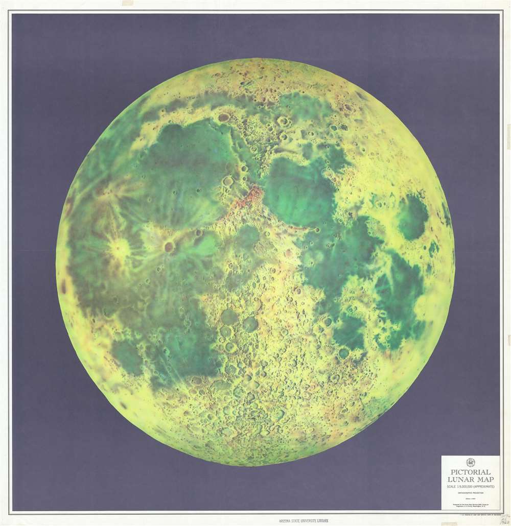
Pictorial Lunar Map.
1963 (dated) 35 x 34.25 in (88.9 x 86.995 cm) 1 : 5000000
1963 (dated) 35 x 34.25 in (88.9 x 86.995 cm) 1 : 5000000
Description
This is a large-format 1963 Army Map Service pictorial map of the Moon. The map depicts the visible face of the Moon in striking detail, with the myriad craters and maria beautifully illustrated. Kepler and Copernicus, two craters in the Oceanus Pocellarum, are strikingly detailed. The lunar maria, or the lunar seas, as early astronomers believed them to be, are colored in such a way to make them appear to be bodies of water, when they are in fact large basaltic plains.
John F. Kennedy, the Space Race, and a Voyage to the Moon
By the end of 1963, the 'Space Race' between the United States and the Soviet Union had kicked up another notch, particularly after President John F. Kennedy challenged, not only NASA an the U.S. military, but the country as a whole, to reach the moon by the end of the decade. During a speech given at Rice University on September 12, 1962, Kennedy declared, 'We choose to go the Moon. We choose to go to the Moon in this decade and do the other things, not because they are easy, but because they are hard.' Even though the Space Race had been going on for almost a decade by the time Kennedy made this pronouncement, this moment is pointed to as the catalyst for the American drive to the Moon. Hence, the creation of this map, with its incredible level of detail, may have been directly influenced by President Kennedy. In an intriguing and tragic coincidence, this map was published by the Army Map Service in November 1963, the same month that President Kennedy was assassinated in Dallas.Publication History and Census
This map was created and published by the Army Map Service in November 1963. It is well represented in institutional collections but scarce on the private market.Cartographer
The Army Map Service (AMS) (1941 - 1968) was the military cartographic agency of the U.S. Department of Defense and part of the U.S. Army Corps of Engineers. The AMS compiled, published, and distributed military topographical maps and other related materials for use by the U.S. Armed Forces. They also prepared maps for space exploration, intelligence reports, and the establishment of world geodetic control networks. Formed during World War II, by the end of the war the Army Map Service had prepared 40,000 maps. 3,000 different maps were created for the Normandy invasion alone. The AMS was instrumental in the Korean War and the Vietnam War, and during all three of these conflicts distributed tens of millions of maps to U.S. servicemen. On September 1, 1968, the AMS was resdesignated the U.S. Army Topographic Command, and continued under this name as an independent organization until January 1, 1972 when it was merged with the new Defense Mapping Agency and renamed the DMA Topographic Center. The Defense Mapping Agency was added to the National Imagery and Mapping Agency on October 1, 1996, which was redesigned the National Geospatial-Intelligence Agency in 2003. More by this mapmaker...
Condition
Very good. Even overall toning. Exhibits old repairs on recto and verso. Bears stamp from Arizona State University on recto and has three red 'WITHDRAWN' stamps on verso.
References
OCLC 1097338081.