This item has been sold, but you can get on the Waitlist to be notified if another example becomes available, or purchase a digital scan.
1929 Marian Brown Pictorial Map of Marblehead, Massachusetts
PictorialMarblehead-brown-1929$175.00

Title
Pictorial Map of Marblehead.
1929 (dated) 19 x 18.75 in (48.26 x 47.625 cm) 1 : 15200
1929 (dated) 19 x 18.75 in (48.26 x 47.625 cm) 1 : 15200
Description
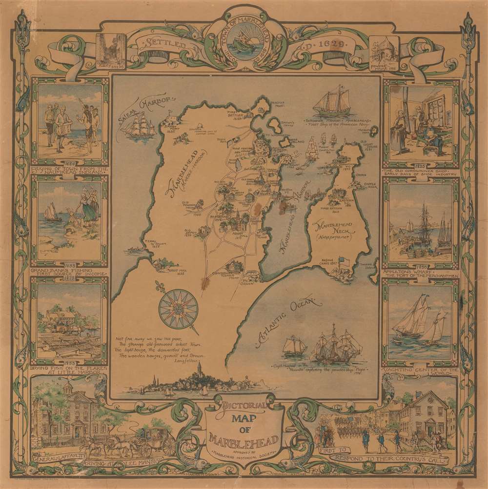
This is a 1929 Marian Martin Brown pictorial map of Marblehead, Massachusetts. Oriented to the northeast, the map depicts the region from Salem Harbor to Tinkers Island and from Peaches Point to the Atlantic Ocean. Beautifully executed, views of historic buildings throughout Marblehead are rendered in profile and labeled, most of which are dated. The Boston Yacht Club, Abbot Hall, St. Michael's Church, Old North Church, and Darby Fort, which dates from 1635, are among these locations. The Schooner Hannah, the first ship in the American Navy, is illustrated to the east of Marblehead, as is the pursuit of the Constitution from the War of 1812. The whole is surrounded by a border consisting of historical vignettes celebrating the early days of the shoe industry, Appleton's Wharf, troops marching off to the Revolutionary War, General Lafayette arriving at the Lee Mansion, and an illustration of settlers 'buying' the town from the Naumkeag Indians.
Publication History and Census
This map was created by Marian Martin Brown and published by the Tudor Press in Boston in 1929. This is the only known example, as it is not catalogued in the OCLC and we are unaware ofCartographer
Marian Martin Brown (December 11, 1888 - June 6, 1972) was an American artist and educator. Born in Marblehead, Massachusetts, she served as the supervisor of arts for Marblehead Public Schools and was an art teacher at Marblehead High School. She also was a artist who designed maps, murals, and greeting cards. More by this mapmaker...
Condition
Good. Backed on archival tissue for stability. Even overall toning. Light soiling. Blank on verso.