This item has been sold, but you can get on the Waitlist to be notified if another example becomes available.
1954 Sargent Pictorial Map of South Africa
PictorialSouthAfrica-sargent-1954$187.50

Title
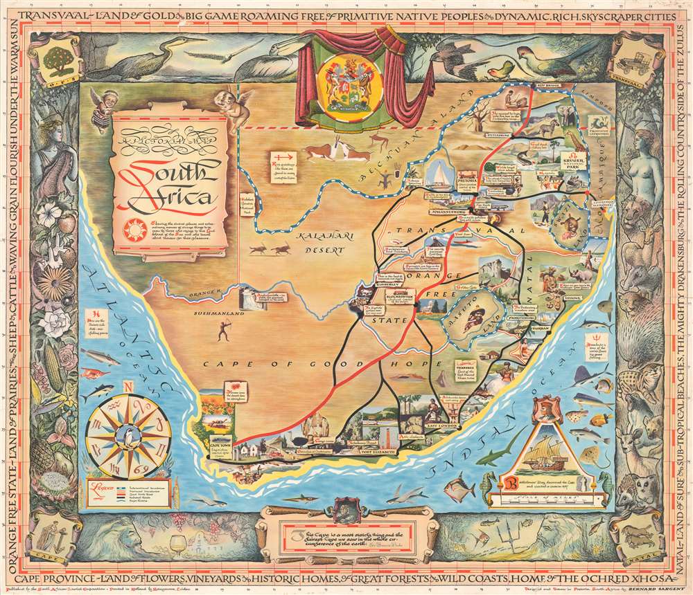
A Pictorial Map: South Africa.
1954 (undated) 25.25 x 29.5 in (64.135 x 74.93 cm) 1 : 3168000
1954 (undated) 25.25 x 29.5 in (64.135 x 74.93 cm) 1 : 3168000
Description
This is a 1954 Bernard Sargent pictorial map of South Africa created for the South African Tourist Corporation. Illustrated vignettes highlight tourism destinations throughout the country but largely focus on South Africa's extraordinary wildlife. Pretoria, Cape Town, and Johannesburg are all labeled, as are the Orange Free State, the Transvaal, and the Cape of Good Hope. Neighboring nations are identified as well, including Swaziland, Basutoland, Bechuanaland, and Mozambique. The whole is surrounded by a stunning pictorial border illustrating South Africa's flora and fauna.
Publication History and Census
This map was designed and drawn by Bernard Sargent in Pretoria, South Africa, and was published in 1954 by the South African Tourist Corporation. Three examples are cataloged in OCLC; located with the institutional collections at the New York Public Library, the University of California-Los Angeles, and the University of Cambridge. Scarce to the market.Cartographer
Bernard Sargent (1921 - 2011) was a commercial artist and illustrator active in South Africa. Sargent was born in Essex, England. He moved to South Africa as a young man, marrying and settling in Johannesburg. Sargent illustrated books and posters on South African history, culture and wildlife, and in 1994, even designed coins for the Bank of Namibia in 1994. More by this mapmaker...
Condition
Good. Exhibits wear along top and bottom margin. Closed margin tears professionally repaired on verso. Repaired tears extending, respectively, one (1) inch and two and one half (2.5) inches into printed area.
References
OCLC 47987274.