This item has been sold, but you can get on the Waitlist to be notified if another example becomes available, or purchase a digital scan.
1939 Stiles Pictorial Historical View of Pittsburgh, Pennsylvania
Pittsburgh1889-ezrastiles-1939$375.00


Title
Pittsburgh in 1889.
1939 (dated) 21.75 x 30.5 in (55.245 x 77.47 cm)
1939 (dated) 21.75 x 30.5 in (55.245 x 77.47 cm)
Description
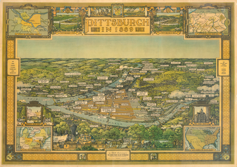
This is Ezra Stiles 1939 pictorial view of Pittsburgh, Pennsylvania as it appeared in 1889, drawn and issued for the 50th anniversary of the Union Trust Company. The view documents the cityscape at the height of Pittsburgh's industrial power, when it was emerging as the heart of the American steel industry.
Depictions of Shanty Boat Row and the Union Trust Co. Building appear at left and right above inset maps of the American Industrial District and the United States in 1839 (a century prior to the view's production), respectively. At top-left is a map of Pittsburgh in 1889, while at top-right is a map of Pennsylvania in 1839. Additional depictions of scenes from the city's history appear in the foreground. A decorative border includes the city seal, views of Pittsburgh in 1795 and 1851, and vignette illustrations of early steel mills and coke ovens.
A Closer Look
Reminiscent of American city views popular in the late 19th century, the era of the city's history depicted, this view is oriented towards the north and focuses on the most developed portion of Pittsburgh near the meeting point of the Ohio, Monongahela, and Allegheny Rivers. Major historical sites, including Forts Pitt, Duquesne, Prince George, and Fayette, the city's first blast furnace, the site of Holy Ghost College (Duquesne University), and other landmarks, are labeled with their founding dates. Many other industrial enterprises, neighborhoods, railroads, bridges, churches, and more are similarly illustrated, with particular attention paid to the industrial district (Strip District) along the Allegheny River. Though the famed Carnegie Steel had not yet been formed, one of its predecessors, Carnegie Phipps and Co., does appear, as do the facilities of Carnegie's main competitor, Jones and Laughlin.Depictions of Shanty Boat Row and the Union Trust Co. Building appear at left and right above inset maps of the American Industrial District and the United States in 1839 (a century prior to the view's production), respectively. At top-left is a map of Pittsburgh in 1889, while at top-right is a map of Pennsylvania in 1839. Additional depictions of scenes from the city's history appear in the foreground. A decorative border includes the city seal, views of Pittsburgh in 1795 and 1851, and vignette illustrations of early steel mills and coke ovens.
Publication History and Census
This view was drawn by landscape architect Ezra C. Stiles and published by the Union Trust Co. of Pittsburgh in 1939 to coincide with the 50th anniversary of the founding of the company. It is scarce, only being noted among the holdings of Dartmouth College and the David Rumsey Historical Map Collection. There are two variants of the present view, the one seen here and one with text below the image (Rumsey 9613.000). A companion piece in a similar style titled 'Pittsburgh in 1939' (Rumsey 12004.000) is equally rare.Cartographer
Ezra Clarke Stiles (September 26, 1891 - January 27, 1974) was an artist, landscape architect, urban planner, and cartographer, long active in Pittsburgh, Pennsylvania. A descendant of prominent Yale University President Ezra Stiles (1727 - 1795), Stiles the younger was born in Upstate New York and attended Pennsylvania State University, earning a degree in Forestry and Landscape Architecture in 1914. He briefly worked as an urban planner in Charlotte, North Carolina and then for a landscape architecture firm in Boston before moving to Pittsburgh in 1915 to work for the landscape design firm A.W. Smith. He joined the U.S. Army during the First World Was and was assigned to the 44th Depot Detachment of Engineers, performing a variety of functions related to his drafting and drawing skills, eventually teaching at the Army Engineer School at Langres, France. Returning to Pittsburgh after the war, Stiles founded his own firm in 1926 and quickly became celebrated as one of the premier landscape architect working in the city, designing gardens for local grandees, universities, corporations, public parks, and others. He even designed two complete parks for Pittsburgh's centennial as well as the McKeesport Rose Garden and Arboretum, and later in his career worked to expand the Allegheny County Park System. Stiles wrote three books on landscape architecture and drew four pictorial maps during his career, the latter including a map of Frick Park in Pittsburgh, a birds-eye view of Pittsburgh in 1939, a related historical view of Pittsburgh in 1889 (the two were reprinted together in a smaller format in Fortune magazine), and, in conjunction with historian Paul Bowman, an historical map of the American Expeditionary Forces in World War I. More by this mapmaker...
Condition
Very good.
References
Rumsey 8168.002. OCLC 82308148.