1710 Homann / Doppelmayr Celestial Chart Explaining Planetary Motion
PlanetaryMotion-homann-1710$750.00

Title
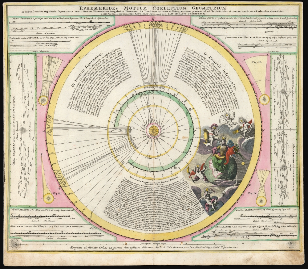
Ephemerides Motuum Coelestium Geometricae.
1710 (undated) 19 x 22.5 in (48.26 x 57.15 cm)
1710 (undated) 19 x 22.5 in (48.26 x 57.15 cm)
Description
This fascinating 1710 celestial chart is a collaboration between mathematician and astronomer Johan Gabriel Doppelmayr and Johann Baptist Homann. It was produced to explain Copernicus' theories of planetary motion and apparent retrograde motion using data from observations in 1708 and 1709.
The purpose of the diagram is to explain the phenomenon of retrograde motion. From the perspective of an observer on Earth, the planets appear to move in a predictable manner - only to apparently reverse direction for a span of months before resuming their journey across the sky. This phenomenon is caused by the fact that while the observed planets move, Earth itself remains in motion, overtaking the slower outer planets (or being overtaken by the inner planets) and creating the illusion of the other planet's apparent reversal. Thus, in addition to the central chart of the solar system, there are diagrams showing the 1708-9 observations of the apparent retrograde motion of each of the planets, keyed to their actual positions on the diagram.
Ingeniously Composed
The ingeniously composed chart is embellished with an allegorical depiction of the discovered planets: Earth is shown as a regal, winged Gaia with a cornucopia; the other planets are putti wearing the classical garb associated with them - Mercury with his winged sandals and caduceus; Venus with a torch (alluding the brightness of the morning star); Mars with sword, shield, and helm; lightning-spitting Jupiter, and Saturn with his scythe and hourglass. Both these latter are attended by their orbiting moons.A Closer Look
The central, circular diagram depicts a simplified Copernican solar system with the sun at center. The diagram's scale prevents the inclusion of Mercury and Venus, and so the first depicted orbit is that of Earth, beyond which are the concentric orbits of Mars, Jupiter, and Saturn. Each orbit is marked with the observed, monthly positions of their respective planets for the years 1708 and 1709, as well as their projected positions throughout the rest of their orbit around the sun (as late as 1757 for Saturn, an overestimation: Saturn's year is only 29.4 of our own.)The purpose of the diagram is to explain the phenomenon of retrograde motion. From the perspective of an observer on Earth, the planets appear to move in a predictable manner - only to apparently reverse direction for a span of months before resuming their journey across the sky. This phenomenon is caused by the fact that while the observed planets move, Earth itself remains in motion, overtaking the slower outer planets (or being overtaken by the inner planets) and creating the illusion of the other planet's apparent reversal. Thus, in addition to the central chart of the solar system, there are diagrams showing the 1708-9 observations of the apparent retrograde motion of each of the planets, keyed to their actual positions on the diagram.
Publication History and Census
This is the first edition of this celestial, engraved for inclusion in the 1710 issue of Homann's Neuer Atlas. It remained in Homann and Homann Heirs atlases well into the 18th century. In its various editions, the map is represented in 18 institutional collections.CartographerS
Johann Baptist Homann (March 20, 1664 - July 1, 1724) was the most prominent and prolific map publisher of the 18th century. Homann was born in Oberkammlach, a small town near Kammlach, Bavaria, Germany. As a young man, Homann studied in a Jesuit school and nursed ambitions of becoming a Dominican priest. Nonetheless, he converted to Protestantism in 1687, when he was 23. It is not clear where he mastered engraving, but we believe it may have been in Amsterdam. Homann's earliest work we have identified is about 1689, and already exhibits a high degree of mastery. Around 1691, Homann moved to Nuremberg and registered as a notary. By this time, he was already making maps, and very good ones at that. He produced a map of the environs of Nürnberg in 1691/92, which suggests he was already a master engraver. Around 1693, Homann briefly relocated to Vienna, where he lived and studied printing and copper plate engraving until 1695. Until 1702, he worked in Nuremberg in the map trade under Jacob von Sandrart (1630 - 1708) and then David Funck (1642 - 1709). Afterward, he returned to Nuremberg, where, in 1702, he founded the commercial publishing firm that would bear his name. In the next five years, Homann produced hundreds of maps and developed a distinctive style characterized by heavy, detailed engraving, elaborate allegorical cartouche work, and vivid hand color. Due to the lower cost of printing in Germany, the Homann firm could undercut the dominant French and Dutch publishing houses while matching their diversity and quality. Despite copious output, Homann did not release his first major atlas until the 33-map Neuer Atlas of 1707, followed by a 60-map edition of 1710. By 1715, Homann's rising star caught the attention of the Holy Roman Emperor Charles VI, who appointed him Imperial Cartographer. In the same year, he was also appointed a member of the Royal Academy of Sciences in Berlin. Homann's prestigious title came with several significant advantages, including access to the most up-to-date cartographic information as well as the 'Privilege'. The Privilege was a type of early copyright offered to very few by the Holy Roman Emperor. Though less sophisticated than modern copyright legislation, the Privilege offered limited protection for several years. Most all J. B. Homann maps printed between 1715 and 1730 bear the inscription 'Cum Priviligio' or some variation. Following Homann's death in 1724, the firm's map plates and management passed to his son, Johann Christoph Homann (1703 - 1730). J. C. Homann, perhaps realizing that he would not long survive his father, stipulated in his will that the company would be inherited by his two head managers, Johann Georg Ebersberger (1695 - 1760) and Johann Michael Franz (1700 - 1761), and that it would publish only under the name 'Homann Heirs'. This designation, in various forms (Homannsche Heirs, Heritiers de Homann, Lat Homannianos Herod, Homannschen Erben, etc.) appears on maps from about 1731 onwards. The firm continued to publish maps in ever-diminishing quantities until the death of its last owner, Christoph Franz Fembo (1781 - 1848). More by this mapmaker...
Johann Gabriel Doppelmayr (September 27, 1677 - December 1, 1750) was a German mathematician and astronomer active in the first half of the 18th century. Doppelmayr was born in Nuremberg to a merchant family. He attended the Aegidien-Gymnasium and the University of Altdorf where he studied mathematics, physics, and law. His graduating dissertation, a study of the Sun, suggests an early interest in Astronomy. Following his studies in Altdorf, Doppelmayr traveled extensively in Europe and is known to have spent time at the University of Halle, as well as in Utrecht, Leiden, Oxford, and London. He returned to Nuremburg in 1704 to take up a mathematics professorship at his alma mater, the Aegidien-Gymnasium. It may have been here that he developed a relationship with the prominent Nuremburg map publisher J. B. Homann, with whom he prepared a number of important astronomical maps and atlases. The collaboration of over 20 years eventually led to the publication of the Atlas Novus Coelestis in 1742. This astounding work was the most elaborate and detailed astronomical atlas yet published and is today much admired for its rich beautifully engraved plates. Doppelmayr died on 1 December 1750 in Nuremberg, and many later sources claim that his death was caused by the fatal effects of a powerful electrical shock which he had received shortly before while experimenting with a battery of electric capacitors. Other sources, however, suggest that Doppelmayr's electrical experiments were performed several years earlier and were not the cause of his death. Today the Lunar crater Doppelmayr and a minor planetoid are named in his honor. Learn More...
Source
Homann, J. B., Neuer Atlas bestehend in einig curieusen Astronomischen Kuppren und vielen auserlesenen accuratensten Land-Charten über die Gantze Welt, (Nuremberg: Homann), 1710.
Homann's Neuer Atlas bestehend in einig curieusen Astronomischen Kuppren und vielen auserlesenen accuratensten Land-Charten über die Gantze Welt was first publihsed in 1707 with 33 maps. A second edition followed in 1710 with 60 maps. Subsequent editions followed until about 1730. The title page notes proudly that the atlas features measurements based on the 'Copernican principle of the moving sky', a truly state-of-the-art innovation for the period. Regardless of editions, collations of the atlas are inconsistent, with some examples having less, while others have more maps - a consequence of the fact that the map sheets were delivered loose, to be bound at the buyer's discretion, and so some buyers chose to omit maps they did not consider relevant, or add others they did. Between editions, the constituent maps, particularly of European regions, were regularly updated to reflect the most recent political events. The atlas continued to be published by Homann's son, J. C. Homann (1703 - 1730), and then by Homann Heirs. Most examples also feature a fine allegorical frontispiece with the title Atlas Novus Terrarum Orbis Imperia, regna et Status, which was used for multiple Homann atlases, including the Neuer Atlas and the Atlas Minor.
Condition
Very good. Old mounting on thick paper for binding; attractive original hand color. Marginal soiling to lower corners; else excellent with no mends or tears.
References
OCLC 248598463. Rumsey 12499.044 (1716 state).