This item has been sold, but you can get on the Waitlist to be notified if another example becomes available, or purchase a digital scan.
1890 Dosseray Wall Map of the World with Comparative Mountains Charts
Planisferio-dosseray-1890$950.00


Title
Nuevo Mapa-Mundi Planisferio Ilustrado con Más Notables Monumentos de España y Portugal, Senalando las divisiones fisicas y politicas de la Tierra y las Colonias de los Estados de Europa, a si como las épocas de los principales descubrimientos.
1890 (dated) 30.25 x 44 in (76.835 x 111.76 cm) 1 : 48000000
1890 (dated) 30.25 x 44 in (76.835 x 111.76 cm) 1 : 48000000
Description
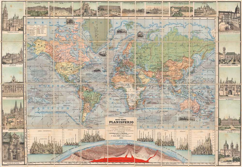
This is a rare 1890 Jean Dosseray map of the world with incorporated comparative mountains charts. The large central map presents a detailed look at the world in 1890, highlighting the vast colonial empires of Great Britain, Denmark, Spain, France, and Portugal. Many of Britain's colonial possessions are underlined in red. Mountains ranges, watersheds, ocean currents, and wind directions are illustrated. Bold black lines trace railroads, including the American Transcontinental Railroad and the Trans-Siberian Railroad (although not yet complete). Vignette illustrations include a boat under polar bear attack and whaling ships, among others.
Comparative Mountain Charts
Seven comparative charts illustrating the worlds' mountains at the bast of the map. Each chart focuses on a different region: North America, the Antilles (the Caribbean Islands), South America, Africa, Europe, Oceania, and Asia. Each mountain is identified by name and location. Volcanos are highlighted with 'V's and are erupting. Below, a cross-section of the Earth's interior includes a bright red molten core. Rock layers are labeled, along with volcanic vents. Above the Earth's surface, the breathable and non-breathable parts of the atmosphere are illustrated as well.Pictorial Border
Illustrations of monuments throughout Spain and Portugal create a pictorial border on three sides of this piece. Each monument in identified by name and the city where it is located. The Views of La Puerta del Sol and the Palacio Real por la Plaza de Oriente in Madrid, the Plaza de Toros in Valencia, the Alhambra in Granada, and churches and cathedrals in Lisbon, Burgos, and Toledo rank among the illustrated locations.Publication History and Census
We note only one example cataloged in OCLC, but in an 1893 edition, at the Biblioteca Nacional de España. We note other records of 1888, 1889, and 1895 editions.Cartographer
Jean Dosseray (1868 - 1904) was a Belgian publisher and editor active in Brussels during the late 19th century. He published science-based maps for schools and tourists. More by this mapmaker...
Condition
Very good. Dissected and mounted on linen in thirty-six (36) panels. Light wear along linen fold lines. Light foxing.