This item has been sold, but you can get on the Waitlist to be notified if another example becomes available, or purchase a digital scan.
1851 Vuillemin Folding Map of the World on Mercator's Projection
Planisphere-vuillemin-1851$450.00

Title
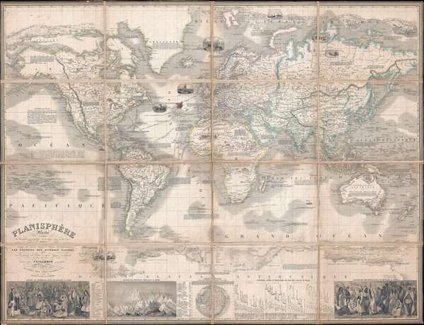
Planisphère Illustré présentant la description géographique des parties connues de la Terre indiquant l'époque des grandes decouverteset le nom des navigateurs, les Coloniess des Diverses Nations ainsi que le percours des bateaux à vapeur, l'époque des départs, la durée du trajet, etc.
1851 (dated) 32.75 x 42.25 in (83.185 x 107.315 cm) 1 : 34000000
1851 (dated) 32.75 x 42.25 in (83.185 x 107.315 cm) 1 : 34000000
Description
This is a rare and magnificent 1851 case map of the world on Mercator's projection by French cartographer Alexandre Vuillemin. The map depicts the world in extraordinary detail with numerous decorative embellishments and prolific notations. Offering 11 decorative vignettes throughout, ranging from whaling ships at sea, to Eskimos hunting in the arctic, to armies of horsemen battling across the Sahara. In the American Northwest, some of Lewis and Clark's recent discoveries are noted and there is some attempt to notate the various American Indian tribes of the region. Alaska is labeled as 'Russian America.' The ice flows of both the Arctic and Antarctic are decoratively and beautifully rendered in profile. Nautical routes between major cities are noted. There are also innumerable historical and textual notations throughout the map, referencing various expeditions, when islands were discovered by European explorers, and other historical events. The bottom portion of the map features two engravings depicting the traditional consumes of various world cultures, along with a chart comparing the elevation of the world's mountains and another comparing the length of its rivers. All text is in French. A much smaller and edited down version of this map was published in Vuillemin's important Atlas Illustré de Géographie Commerciale et Industrielle. Edited by Fatout of No 17, Boulevard Poissoniere in Paris.
Cartographer
Alexandre Aimé Vuillemin (1812 - 1880) was an engraver, publisher, and editor based in Paris, France in the middle of the 19th century. Despite a prolific publishing career, much of Vuillemin's life is shrouded in mystery. In 1852, he married Josephine Caroline Goret and they had at least one child, Ernestine Adèle Vuillemin, later in the same year. What is known is that his studied under the prominent French Auguste Henri Dufour (1798 - 1865). Vuillemin's most important work his detailed, highly decorative large format Atlas Illustre de Geographie Commerciale et Industrielle. More by this mapmaker...
Condition
Very good. Dissected into 16 panels and mounted on linen. Light soiling. Blank on verso.
References
Brown A Journey Back in Time Through Maps, p. 176-77. OCLC 71599711.