This item has been sold, but you can get on the Waitlist to be notified if another example becomes available, or purchase a digital scan.
1910 El Siglo Map or Plan of Barcelona, Spain
PlanoBarcelona-elsiglo-1910$150.00

Title
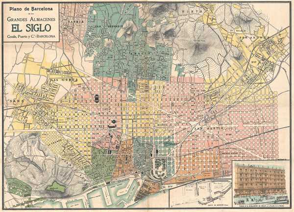
Plano de Barcelona de los Grandes Almacenes El Siglo.
1910 (undated) 19 x 26 in (48.26 x 66.04 cm) 1 : 15000
1910 (undated) 19 x 26 in (48.26 x 66.04 cm) 1 : 15000
Description
This is a 1910 Conde, Puerto y Ca. map or plan of Barcelona, Spain. The map depicts from the Sans neighborhood in the seventh district and the Cementerio del Oeste on the left to the ninth district and the San Andrés neighborhood on the right and from the Sarriá neighborhood and the San Gervasio neighborhood in the eighth district at the top to the second, third, and fourth districts at the bottom. Each district is depicted in a different color, which creates a very attractive aesthetic. All the main roads are labeled. Some of the smaller roads are labeled as well, depending on the district. Hospitals, the university, and churches are noted. In the lower right corner is an inset map of the Port of Barcelona and a depiction of the façade of the Almacenes 'El Siglo' headquarters.
This map was published by Conde, Puerto y Ca. in Barcelona for in inclusion in the El Siglo almanac.
This map was published by Conde, Puerto y Ca. in Barcelona for in inclusion in the El Siglo almanac.
Condition
Very good. Blank on verso. Backed on archival tissue.