1867 Depot de la Marine Nautical Chart or Map of Saint Martin Bay, Ile de Re, France
PlanSaintMartin-marine-1867$650.00

Title
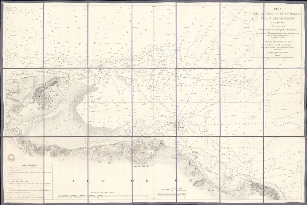
Plan de la Rade de Saint Martin et de ses Environs. (Ile de Ré).
1867 (dated) 23.5 x 35.25 in (59.69 x 89.535 cm) 1 : 145827
1867 (dated) 23.5 x 35.25 in (59.69 x 89.535 cm) 1 : 145827
Description
This is an 1867 French Dépôt de la Marine nautical chart or maritime map of Saint Martin Bay, Ile de Ré, France. Depicting the north shore of the Ile de Ré from Loix to La Flotte, hundreds of depth soundings populate the bay. Saint Martin appears at bottom center, with the city's fortifications illustrated in detail.
The Ile de Ré
The Ile de Ré sits off the coast of France in the Bay of Biscay not far from La Rochelle. The island changed hands several times between the English and French between 12th and 14th centuries. Ile de Ré commands coastal France from Nantes to Bordeaux, making it a prized possession, particularly during in the 17th century. It was the center of a Huguenot revolt in 1625 and the English unsuccessfully laid siege to Saint-Martin-de-Ré in 1627. Vauban fortified Saint Martin in 1681 and the city served as one of the depots through which convicts transited on their way to penal colonies in New Caledonia and French Guiana. Alfred Dreyfus was one of the many prisoners to pass through Saint Martin. The Nazis fortified the Ile de Ré during World War II, and some of the bunkers remain, which led to scenes from The Longest Day being filmed on the island's beaches. Today, the Ile de Ré is popular as an elite vacation destination.Publication History and Census
The first edition of this map was created for the Dépôt de la Marine under the supervision of Charles-François Beautemps-Beaupré and published in 1831. The present example was updated by Anatole Bouquet de la Grye in 1867 and published by the Dépôt de la Marine. This is the only cataloged example of the present edition. We note two cataloged examples of the first edition.CartographerS
Dépôt des Cartes et Plans de la Marine (fl. 1720 - present), often called the Dépôt de Marine, was a French hydrographic mapping organization founded in 1720 under Charles-Hercule of Albert de Luynes (1674 - 1734). Much like the U.S. Coast Survey, the British Admiralty, and the Spanish Deposito Hydrografico, the Dépôt was initiated as a storehouse and distribution center of existing nautical and marine charts. Eventually the Dépôt initiated its own mapping activities in an attempt to improve and expand upon existing material. Some of the more prominent cartographers and hydrographers associated with the of Dépôt des Cartes were, Philippe Buache, Jacques-Nicholas Bellin, Giovanni Rizzi-Zannoni, Rigobert Bonne, and Jean Nicolas Buache. More by this mapmaker...
Anatole Bouquet de La Grye (May 29, 1827 - December 21, 1909) was a French hydrographic engineer. He graduated from the École Polytechnique in 1847. Bouquet de la Grye created maps of the island of Elbe, Tuscany, New Caledonia, and Alexandria over the course of his career. His most notable accomplishment was proposing and championing the creation of a La Pallice (also known as the grand port maritime de La Rochelle), a large deep-water commercial port at La Rochelle, France. He was elected as a member of the Academy of Sciences in 1884 and became President of the Academy in 1902. Learn More...
Charles-François Beautemps-Beaupré (August 6, 1766 - March 16, 1854) was a French hydrographic engineer and cartographer and was also a member of the Academy of Sciences. He is considered the father of modern hydrography. Beautemps-Beaupré began his career as a hydrographer in 1783 as a student of his uncle Jean-Nicolas Buache, who was the director of the dépôt de la Marine at the time. He became an engineer in 1785 and created his first maps that year. He was a member of the crew of La Recherche, which left France in 1791 under the command of Antoine Reymond Joseph de Bruni d'Entrecasteaux in search of the French explorer La Pérouse, who had disappeared in 1788. The expedition with La Recherche lasted until 1796, and Beautemps-Beaupré took advantage of these years to develop new foundations for hydrography, developing it into a true science and adopting methods that would soon be adopted by all mariners. When L'Appendice au voyage de D'Entrecasteaux was published in 1808, it contained all Beautemps-Beaupré's work from the voyage and it 'revolutionized hydrographic methods'. Beautemps-Beaupré was made sub curator of the dépôt des cartes et plans de la marine in 1799 and was put in charge of all major hydrographic work during the Empire and the Bourbon Restoration, making him among the few government officials to serve during both periods. He was elected to the Academy of Sciences in 1810. He was mad director of the dépôt des cartes et plans de la marine in 1814 and held the position until 1838. Over the course of his career, Beautemps-Beaupré created at least 613 distinct works, including over 150 maps and plans and 279 views. Learn More...
Condition
Very good. Dissected and mounted on linen in twenty-one (21) panels.