1845 Butler Land Office Map of Florida
PlatFlorida-butler-1845$650.00

Title
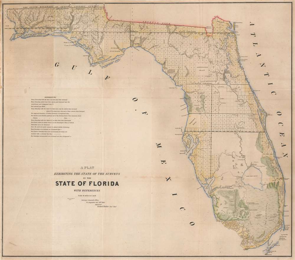
A Plat Exhibiting the State of the Surveys in the State of Florida with References.
1845 (dated) 22.5 x 25.5 in (57.15 x 64.77 cm) 1 : 1140480
1845 (dated) 22.5 x 25.5 in (57.15 x 64.77 cm) 1 : 1140480
Description
One of the first (if not the first) maps of Florida after it became a state, this is an 1845 Robert Butler map of Florida illustrating the progress of the Public Land Survey System in the newly admitted state.
A Closer look
Most of Florida is platted into square townships, a measure of the Public Land Survey System (PLSS). The PLSS was first widely implemented to survey the Northwest Ordinance and allowed for the systematic surveying and mapping of any territory gained by the United States. Cities and towns are marked, including St. Augustine and Pensacola, and Fort Lauderdale. The Arredondo Grant and the Forbes Purchase are both noted. Rivers and creeks are illustrated and labeled.The Arredondo Grant
Arredondo's Grant is a holdover from Spanish Florida. Beginning in the 1790s, the Spanish crown offered land grants to people courageous enough to emigrate to Florida or for meritorious service to the crown. Arredondo's grant, named after Fernando de la Maza Arredondo (c. 1760 - 18??), is located to the west of St. Augustine in Alachua County. It was granted to Arredondo in 1817 by Alexander Ramirez of Havana. After Florida became a possession of the United States in 1821, Arredondo's grant, and other grants ceded by the Spanish government, became a point of contention between the United States government and the grantees. Initially, the U.S. government declared that it would honor the grants as long as the owner could prove their legitimacy. Fernando de la Maza Arredondo took his case to the United States Supreme Court, where his rights to the land were affirmed. Eventually, nonetheless, his grant was dissolved by U.S. courts on the basis that it were not properly developed and therefore forfeited.Forbes Purchase
Forbes Purchase appears here as a large tract of land in the Florida Panhandle. The lands were acquired from various Lower Creek and Seminole Indian groups in the early 19th century to pay off debt owed to Panton, Leslie and Company (later, the John Forbes company). Panton, Leslie and Company, 'company' being John Forbes (1767 - 1823), were Scottish merchants who actively traded with American Indians in Florida. Under both the British and Spanish, they were granted monopiles in East Florida, but also controlled most of the Indian trade in West Florida. As British Loyalists, they were vehemently against the United States, and actively encouraged their Indian contacts to war against the new nation. When William Paton and John Leslie died, c. 1803, the firm was reorganized around the surviving partner as John Forbes and Company. Over the years, the Lower Creek and Seminole groups accrued enormous debt to the firm. In order to pay the debt, they ceded enormous tracts of land in the Florida Panhandle to the Spanish government, which in turn passed the deeds on to John Forbes, hence 'Forbes' Purchase.' Forbes sold most of the land to two merchants from Savannah and Cuba named Richard Carnochan and Colin Mitchel. After Florida became part of the United States, there was an attempt by the government to seize this land, but the Supreme Court prevented the government seizure. In time it became clear that Forbes Purchase was mostly uninhabitable swampland, near impossible to develop, and so was ultimately sold off in lots.Publication History and Census
This map was created by the Florida Surveyor General's Office, approved by Surveyor General Robert Butler, engraved by Smith and McClelland, and published in a report to the United States Senate by the General Land Office in 1845. We note two cataloged examples which are part of the collection of the Touchton Map Library at the Tampa Bay History Center. The present 1845 edition is not cataloged in OCLC.CartographerS
Robert Butler (December 29, 1786 - January 13, 1860) was an American military officer and government surveyor. Born in Carlisle, Pennsylvania, Butler's father, Colonel Thomas Butler (1748 - 1805) died of yellow fever in 1805 and Butler and his siblings became wards of future president Andrew Jackson. Butler married Rachel Hays (General Jackson's niece) in August 1808. He was a graduate of West Point and served as General Jackson's Assistant Adjutant-General during the Battle of New Orleans during the War of 1812. He resigned from the U.S. Army in 1821, having attained the ranks of colonel and commander. He became the acting Governor of East Florida on July 10, 1821 (possibly why he resigned from the Army?) and served for only two days when John R. Bell arrived. He was appointed the first Surveyor General of Florida in 1824 and held the position until 1848. He is responsible for one of, if not the, first maps of Florida after it became a state in 1845. More by this mapmaker...
The General Land Office (GLO) (1812 - 1946) was an independent agency of the United States government responsible for public domain lands in the United States. Created in 1812, it took over functions previously conducted by the Department of the Treasury. The GLO oversaw the surveying, platting, and sale of public lands in the western United States. It also administered the Preemption Act of 1841, which allowed individuals who were already living on federal land to purchase up to 160 acres of land before it was offered for sale to the general public, if they met certain requirements. Following the passage of the Homestead Act in 1862, which was also administered by the GLO, claims under the Preemption Act sharply decreased. The GLO became a part of the newly-created Department of the Interior in 1849. In 1891 Grover Cleveland and Congress created 17 forest reserves, due to public concern over forest conservation, which were initially managed by the GLO, until they were transferred to the Forest Service in 1905. In 1946 the Government Land Office was merged with the United States Grazing Service to become the Bureau of Land Management. Today the Bureau of Land Management administers the roughly 246 million acres of public land remaining under federal ownership. Learn More...
David McClelland (1820 - 1899) was a Washington D.C. based copper plate engraver and publisher active from at least 1840 to about 1876. His work mainly consists of maps and other engraved documents for government publications, including maps for the Army Bureau of Topographical Engineers, Senate Reports, and General Land Office. In 1840, when he was just 19, McClelland was partnered with William Smith under the imprint of 'Smith and McClelland' with offices on Pennsylvania Avenue between 2nd and 3rd. The ordering of names in the imprint suggests that Smith was the senior partner, possibly the person who trained McClelland in engraving. While there is little evidence of Smith, there was an engraver of this name in Washington D.C. doing government engraving in the 1850s, and another living in Philadelphia. It is unclear if they are the same or different individuals. The partnership eventually dissolved, at which point Smith moved to Pennsylvania Avenue near 11h Street and McClellend to the Old Medical Collage at 10th and East Streets. McClelland is best known for his engraving of the important 1861 Albert Boschke map of Washington D.C. and the 1846 Topographical Engineers map of Florida. In 1863, during the American Civil War, McClelland had an altercation with the Federal Government War Department over the plates for the Boschke Map, which he owed in partnership with several others. The plates were ultimately seized without compensation for war use. After the war, McClelland appealed to Congress for restitution, which was finally granted in the 1890s. In the 1860s, McClelland published under the imprint of 'D. McClelland, Blanchard and Mohun' and 'D. McClelland, Blanchard and Mohun, Hugh b. Sweeny and Thomas Blagdon.' McClelland lived in Le Droit Park and is possibly responsible for that neighborhood being named as such. Learn More...
Condition
Very good. Light wear along original fold lines. Small areas of infill in left margin.
References
Tampa Bay History Center, Touchton Map Library L2018.098.026, L2011.070.097.