
1888 Whiteley and Rand McNally Pocket Map of Ohio

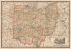

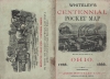
Whiteley's Centennial Pocket Map of the Great State of Ohio.
Ohio's centennial and Whiteley reapers.
- Digital Map Information
- Suitable for large format printing
- Full resolution TIFF file
- ICC color profile embedded
- Delivered instantly via download link
Ohio's centennial and Whiteley reapers.
Celebrating Ohio's centennial, this 1888 Whitely and Rand McNally map of Ohio recognizes one of Ohio's most successful businesses, Whiteley's. Amos Whitely and his brother William operated farm equipment businesses in Springfield, Ohio after William patented improvements to the reaper, a grain and grass harvester. William's invention garnered worldwide attention and earned him the nickname 'Reaper King'. An advertisement for Whiteley's occupies the entire verso.A Closer Look
The map focuses on the Ohio railroad network, with each line identified by name. The highlight is an advertisement for Amos Whiteley's solid steel mower in the lower right.Publication History and Census
This map was created by Rand McNally and Company and published by Amos Whiteley and Company in 1888. We note three examples cataloged in OCLC: Cleveland Public Library, the Ohio History Connection, and the University of Michigan. An example is also part of the David Rumsey Map Collection.Cartographer
Rand, McNally and Co. (fl. 1856 - present) is an American publisher of maps, atlases and globes. The company was founded in 1856 when William H. Rand, a native of Quincy, Massachusetts, opened a print shop in Chicago. Rand hired the recent Irish immigrant Andrew McNally to assist in the shop giving him a wage of 9 USD per week. The duo landed several important contracts, including the Tribune's (later renamed the Chicago Tribune) printing operation. In 1872, Rand McNally produced its first map, a railroad guide, using a new cost effective printing technique known as wax process engraving. As Chicago developed as a railway hub, the Rand firm, now incorporated as Rand McNally, began producing a wide array of railroad maps and guides. Over time, the firm expanded into atlases, globes, educational material, and general literature. By embracing the wax engraving process, Rand McNally was able to dominate the map and atlas market, pushing more traditional American lithographic publishers like Colton, Johnson, and Mitchell out of business. Eventually Rand McNally opened an annex office in New York City headed by Caleb S. Hammond, whose name is today synonymous with maps and atlases, and who later started his own map company, C. S. Hammond & Co. Both firms remain in business. Further Details...
Condition
Very good. Light wear along original fold lines. Advertisement on verso. Accompanied by original binder.
References
Rumsey 0827.002. OCLC 36623980.