1960 Boy Scouts of America Pictorial Map of Philmont Scout Ranch, New Mexico
PhilmontScoutRanch-bsa-1960$250.00


Title
Philmont Scout Ranch Cimarron New Mexico.
1960 (dated) 39 x 28 in (99.06 x 71.12 cm) 1 : 48000
1960 (dated) 39 x 28 in (99.06 x 71.12 cm) 1 : 48000
Description
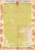
A celebrated aspect of outdoor recreation for the Boy Scouts of America, this is a c. 1960 Boy Scouts of America pictorial map of the Philmont Scout Ranch in New Mexico. Thousands of Scouts visit the ranch annually, experiencing the wonders of America at this National High Adventure Base.
A Closer Look
Using U.S. Geological Survey topographic maps, Philmont's many camps (where backpackers spend nights) and trails are identified. Philmont landmarks, including Baldy Mountain and the Tooth of Time are labeled. A red line highlights Philmont's boundaries. A pictorial border surrounds the map and includes illustrations of Scouts practicing archery, fishing, shooting, and rock climbing, as well as images of the area's vistas and wildlife. The Tooth of Time and a covered wagon appear along the bottom border.Philmont Scout Ranch
Philmont Scout Ranch, near Cimarron, New Mexico, was first donated to the Boy Scouts by Waite Phillips, an oil baron, in 1938. He expanded his initial donation in 1941. Today, it is one of the largest youth camps in the world at over 140,000 acres. Crews of Scouts and Venturers participate in backpacking treks and other outdoor activities, with an estimated 24,000 Scouts and adult leaders taking part in treks in 2019.Publication History and Census
This map was created by the Boy Scouts of America using U.S. Geological Survey quadrangle topographic maps surveyed in 1955 - 1956 and printed by A. B. Hirschfeld Press of Denver Colorado. Maps like this one were used by boy scouts at Philmont beginning in the late 1950s or early 1960s through the early 1980s when the maps started being lightly 'waterproofed'. The present map is paper, making it certain that it predates the 1980s. At least five examples are cataloged in OCLC and are part of the collections at the University of Michigan, Western Michigan University, the University of Wyoming, the New Mexico Office of State Engineer Library, and the University of New Mexico.CartographerS
The Office of the Coast Survey (later the U.S. Geodetic Survey) (1807 - present), founded in 1807 by President Thomas Jefferson and Secretary of Commerce Albert Gallatin, is the oldest scientific organization in the U.S. Federal Government. Jefferson created the "Survey of the Coast," as it was then called, in response to a need for accurate navigational charts of the new nation's coasts and harbors. The first superintendent of the Coast Survey was Swiss immigrant and West Point mathematics professor Ferdinand Hassler. Under the direction of Hassler, from 1816 to 1843, the ideological and scientific foundations for the Coast Survey were established. Hassler, and the Coast Survey under him developed a reputation for uncompromising dedication to the principles of accuracy and excellence. Hassler lead the Coast Survey until his death in 1843, at which time Alexander Dallas Bache, a great-grandson of Benjamin Franklin, took the helm. Under the leadership A. D. Bache, the Coast Survey did most of its most important work. During his Superintendence, from 1843 to 1865, Bache was steadfast advocate of American science and navigation and in fact founded the American Academy of Sciences. Bache was succeeded by Benjamin Pierce who ran the Survey from 1867 to 1874. Pierce was in turn succeeded by Carlile Pollock Patterson who was Superintendent from 1874 to 1881. In 1878, under Patterson's superintendence, the U.S. Coast Survey was reorganized as the U.S. Coast and Geodetic Survey (C & GS or USGS) to accommodate topographic as well as nautical surveys. Today the Coast Survey is part of the National Oceanic and Atmospheric Administration or NOAA. More by this mapmaker...
The A. B. Hirschfeld Press (1907 - 2005) was founded by A. B. (Abraham Bernard) Hirschfeld (1888 - 1957) in Denver, Colorado, in 1907. A. B. Hirschfeld was born in Cincinnati, Ohio, and moved to Denver in 1904. He founded the Press in the basement of a fruit stand at 17th and Larimer Streets with a $39 hand-operated press. The company continued expanding, and Hirschfeld's son Edward Hirschfeld (1907 - 1984) joined the family firm at age 15. By 1949, the A. B. Hirschfeld Press was the largest printer between Chicago and the West Coast. Edward's son A. Barry Hirschfeld joined the company in 1966 after graduating from California State Polytechnic University. A.B. Hirschfeld Press merged with the National Printing and Packaging Company, digital printer C and M Press LLC, and the printing software firm OSI6 LLC in 2005. The firm closed on January 20, 2009. Learn More...
Condition
Good. Wear along fold lines. Infill at a few fold intersections and to covered wagon in lower left corner. Light foxing.
References
OCLC 1194608131.