1816 Thomson Map of Jamaica
Jamaica-thomson-1816$300.00

Title
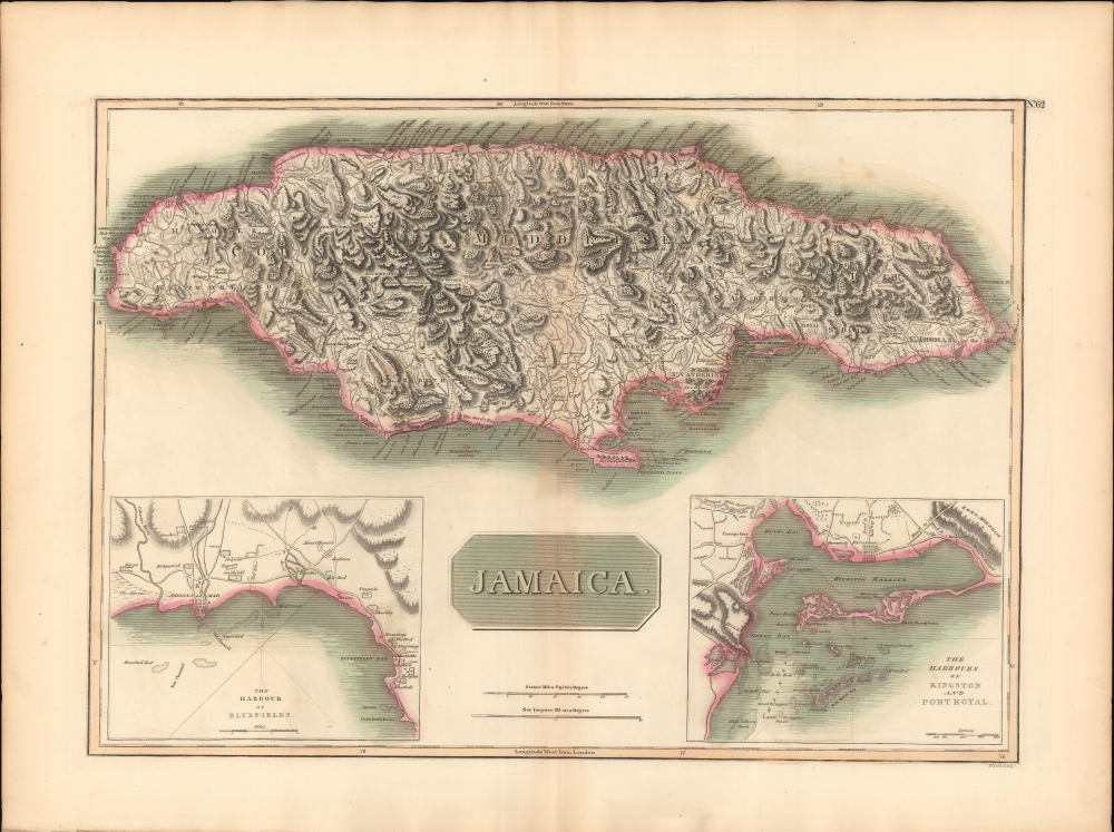
Jamaica.
1816 (undated) 18 x 25 in (45.72 x 63.5 cm) 1 : 500000
1816 (undated) 18 x 25 in (45.72 x 63.5 cm) 1 : 500000
Description
This is a striking 1816 map of Jamaica issued by John Thomson. The map illustrates Jamaica when it was one of Britain's most profitable West Indian colonies, but also suffering island-wide instability as the indigenous and African populations struggled to throw off the yoke of slavery.
A Closer Look
Cartographically, the map derives from the 1775 Thomas Jefferys map, the best 18th source available. Coverage embraces the full island with attention to roads and topography, and is strikingly engraved. Insets detail the harbors of Kingston, Port Royal, and Bluefields.Publication History and Census
This map was prepared and engraved in 1816 in Edinburgh by John Neele for inclusion in the 1817 first edition of John Thomson's New General Atlas.CartographerS
John Thomson (1777 - c. 1841) was a Scottish cartographer, publisher, and bookbinder active in Edinburgh during the early part of the 19th century. Thomson apprenticed under Edinburgh bookbinder Robert Alison. After his apprenticeship, he briefly went into business with Abraham Thomson. Later, the two parted ways, John Thomson segueing into maps and Abraham Thomson taking over the bookbinding portion of the business. Thomson is generally one of the leading publishers in the Edinburgh school of cartography, which flourished from roughly 1800 to 1830. Thomson and his contemporaries (Pinkerton and Cary) redefined European cartography by abandoning typical 18th-century decorative elements such as elaborate title cartouches and fantastic beasts in favor of detail and accuracy. Thomson's principle works include Thomson's New General Atlas, published from 1814 to 1821, the New Classical and Historical Atlas of 1829, and his 1830 Atlas of Scotland. The Atlas of Scotland, a work of groundbreaking detail and dedication, would eventually bankrupt the Thomson firm in 1830, at which time their plates were sequestered by the court. The firm partially recovered in the subsequent year, allowing Thomson to reclaim his printing plates in 1831, but filed again for bankruptcy in 1835, at which time most of his printing plates were sold to A. K. Johnston and Company. There is some suggestion that he continued to work as a bookbinder until 1841. Today, Thomson maps are becoming increasingly rare as they are highly admired for their impressive size, vivid hand coloration, and superb detail. More by this mapmaker...
Thomas Clerk (March 30, 1779 - January 1, 1861) was a Scottish engraver active in Edinburgh in the early part of the 19th century. Clerk engraved extensively for John Thomson and Thomas Brown, among others in a career spanning nearly 50 years. Learn More...
Baldwin and Cradock (fl. c. 1810 - 1860) were London based publishers working in the early to mid 19th century. They are best known for their publication of the Society for the Diffusion of Useful Knowledge's ground breaking subscription atlas. They also published John Thomson's magnificent New General Atlas from 1814 - c. 1820. In addition to their cartographic corpus, the firm had wide ranging publishing interests in many other areas, including books, broadsides, and an investment in Blackwoods Magazine. They had their offices at 47 Paternoster Row, London, England. This firm also published under the imprint Baldwin, Cradock, and Joy and Cradock and Joy. Learn More...
Source
Thomson, J., A New General Atlas, (Edinburgh: Baldwin, Cradock, Joy) 1817.
Thomson's New General Atlas was first published in 1817 and continued to be published until about 1821. This is the first of Thomson's major cartographic works and the atlas for which is most celebrated. The New General Atlas follows in the Edinburgh School, which eschews excessive decoration in favor of a more minimalistic fact-based cartographic vision, as established by John Pinkerton, Laurie and Whittle, John Cary, and others in the previous decades. The maps are notable for their massive scale, heavy stock, elegant color work, and easy-to-read typefaces. Although the atlas stopped being published after 1821, Thomson continued to offer 'supplementary' maps that could be tipped into the atlas as late as 1830, when he declared bankruptcy. The maps in the Thomson Atlas were engraved by Thomas Clerk, William Dassauville, Nathaniel Rogers Hewitt, James Kirkwood, Robert Kirkwood, John Menzies, George Menzies, Edward Mitchell, John Moffatt, Samuel John Neele, Robert Scott, and James Wyld.
Condition
Very good. Wide margins. Original platemark. Some centerfold wear and toning. Some offsetting.
References
Rumsey 1007.068. Catalogue of maps of Hispanic America, v. 1, p. 245. Kapp, K.S., Printed maps of Jamaica up to 1825, 145 (1814 ed.).