This item has been sold, but you can get on the Waitlist to be notified if another example becomes available, or purchase a digital scan.
1794 Laurie and Whittle Map of Poland and Lithuania after Second Partition
Poland-lauriewhittle-1794$325.00

Title
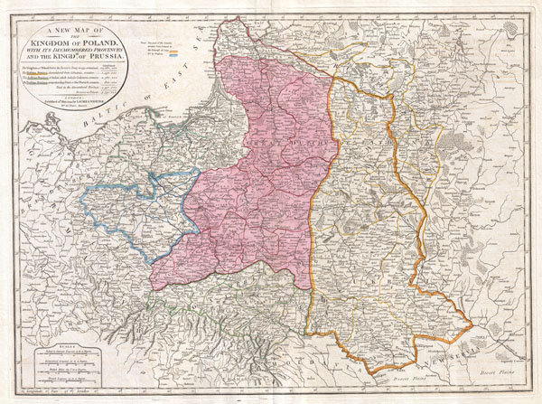
A New Map of the Kingdom of Poland, with its Dismembered Provinces and the Kingdom of Prussia.
1794 (dated) 19.5 x 26 in (49.53 x 66.04 cm)
1794 (dated) 19.5 x 26 in (49.53 x 66.04 cm)
Description
This important 1794 map by Thomas Kitchin depicts the Kingdom of Poland during the brief transitional period between the second and third partitions. Covers from Brandenburg to Russia and from the Gulf of Livonia to Moldova and Hungary, including all of Poland and the Grand Duchy of Lithuania, parts of Prussia, Russia, Livonia, Hungary, Germany and Austria. This map depicts Poland in 1794, immediately following the Second Partition of Poland in 1793. By the mid 18th century Poland, due to an inefficient and corrupt internal bureaucracy, had lost much of its autonomy to its aggressive and powerful neighbors, Russia, Austria and Prussia. The First Partition occurred in 1772 with Prussia occupying Poland's long coveted western territories, Austria seizing Galicia, and Russia taking part of Livonia. In the aftermath of the First Partition, the Second Partition was almost inevitable. Poland allied with Prussia to thwart the ambitions of Russia in the East. This, along with a number of other factors, lead to the War in Defense of the Constitution between Poland and Russia. Largely abandoned by their Prussian allies, Poland could not hope to stand against the powerful Russian military. Poland's defeat resulted in the loss of nearly 50% of its remaining territory to Russia and Prussia, who signed an accord in 1793. One year after this map was made, in 1795, the Third Partition of Poland would dissolve what remained of the reduced Polish-Lithuanian Commonwealth, ending Polish all autonomy in the 18th century.
All text is in English. This map was drawn in London by Thomas Kitchin based on an earlier map of the region by D'Anville. Published by Laurie and Whittle in 1794 from their office at 53 Fleet Street, London, England.
All text is in English. This map was drawn in London by Thomas Kitchin based on an earlier map of the region by D'Anville. Published by Laurie and Whittle in 1794 from their office at 53 Fleet Street, London, England.
CartographerS
Thomas Kitchin (August 4, 1718 – June 23, 1784) was a London based engraver, cartographer, and publisher. He was born in London to a hat-dyer of the same name. At 14, Kitchin apprenticed under Emanuel Bowen, under whom he mastered the art of engraving. He married Bowen daughter, Sarah Bowen, and later inherited much of his preceptor's prosperous business. Their son, Thomas Bowen Kitchin, also an engraver joined the family business, which thereafter published in Thomas Kitchin and Son. From 1858 or so Kitchin was the engraver to the Duke of York, and from about 1773 acquired the title, 'Royal Hydrographer to King George III.' He is responsible for numerous maps published in the The Star, Gentleman's Magazine, and London Magazine, as well as partnering with, at various times, with Thomas Jefferys, Emmanuel Bowen, Thomas Hinton, Issac Tayor, Andrew Dury, John Rocque, Louis de la Rochette, and Alexander Hogg, among others. Kitchin passed his business on to his son, Thomas Bowen Kitchin, who continued to republish many of his maps well after his death. Kitchin's apprentices included George Rollos, Bryant Lodge, Thomas Bowen Kitchin, Samuel Turner Sparrow, John Page, and Francis Vivares. More by this mapmaker...
Laurie and Whittle (fl. 1794 - 1858) were London, England, based map and atlas publishers active in the late 18th and early 19th century. Generally considered to be the successors to the Robert Sayer firm, Laurie and Whittle was founded by Robert Laurie (c. 1755 - 1836) and James Whittle (1757-1818). Robert Laurie was a skilled mezzotint engraver and is known to have worked with Robert Sayer on numerous projects. James Whittle was a well-known London socialite and print seller whose Fleet Street shop was a popular haunt for intellectual luminaries. The partnership began taking over the general management of Sayer's firm around 1787; however, they did not alter the Sayer imprint until after Sayer's death in 1794. Apparently Laurie did most of the work in managing the firm and hence his name appeared first in the "Laurie and Whittle" imprint. Together Laurie and Whittle published numerous maps and atlases, often bringing in other important cartographers of the day, including Kitchin, Faden, Jefferys and others to update and modify their existing Sayer plates. Robert Laurie retired in 1812, leaving the day to day management of the firm to his son, Richard Holmes Laurie (1777 - 1858). Under R. H. Laurie and James Whittle, the firm renamed itself "Whittle and Laurie". Whittle himself died six years later in 1818, and thereafter the firm continued under the imprint of "R. H. Laurie". After R. H. Laurie's death the publishing house and its printing stock came under control of Alexander George Findlay, who had long been associated with Laurie and Whittle. Since, Laurie and Whittle has passed through numerous permeations, with part of the firm still extant as an English publisher of maritime or nautical charts, 'Imray, Laurie, Norie and Wilson Ltd.' The firm remains the oldest surviving chart publisher in Europe. Learn More...
Source
Kitchin, Thomas, Kitchin's General Atlas, describing the Whole Universe: being a complete collection of the most approved maps extant; corrected with the greatest care, and augmented from the last edition of D'Anville and Robert with many improvements by other eminent geographers, engraved on Sixty-Two plates, comprising Thirty Seven maps., Laurie & Whittle, London, 1797.
Condition
Very good condition. Original centerfold. Blank on verso. Original platemark visible. Wide clean margins.
References
Rumsey 0411.026. Phillips (Atlases) 6008-22. Malinowski, H., The Malinowski collection of maps of Poland, 201 (17684 ed.).