
This item below is out of stock, but another example (left) is available. To view the available item, click "Details."
Details
1540 / 1556 Münster Map of Poland and Hungary
$650.00
1540 Munster Map of Poland and Hungary: First Contemporaneous Map of the Region
PolandHungary-Munster-1540$375.00

Title
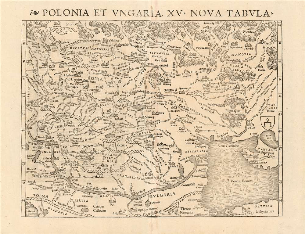
Polonia et Ungaria, XV. Nova Tabula.
1540 (undated) 10.5 x 13.5 in (26.67 x 34.29 cm)
1540 (undated) 10.5 x 13.5 in (26.67 x 34.29 cm)
Description
This is the scarce 1540 first state of Sebastian Münster's map of Poland and Hungary, the first map to focus on the region using contemporary place names and geographical knowledge. The only earlier printed maps to focus at all on the region were iterations of Ptolemy's maps of Sarmatia in Europe; the nearest contender for an earlier modern map of the region is Waldseemüller's 1513 Tabula moderna Sarmatie which was of broader scope (reaching as far west as Germany and the Bavarian Alps) and whose geography for the region is far more primitive. Münster's map is the first of this region to present the reader with a largely recognizable depiction of Poland and Hungary.
The southern reaches of the map are dominated by the River Danube: Both Buda and Pest appear as do the mountains of Transylvania. Bosnia, Serbia and Bulgaria are all shown along the southern shore of the Danube, whose broad delta into the Black Sea is clearly depicted. Constantinople can just be seen at the southern edge of the map. Tartaria, shown at the eastern extreme of the map, is marked with a heraldic shield bearing a stylized spur; this was the symbol Waldseemüller used on his 1507 world map to indicate the Tatar empire, so is suggestive of Munster’s primary source for this map - despite the present map having outstripped Waldseemüller's treatment of the area in every respect.
The Scope of the Map
The map's northern extents pertain to Poland: at its northernmost point is Prussia. The capitol, Krakow, is shown; Warsaw had not yet become a royal city and would not rise to prominence until the end of the 16th century. The Duchy of Masovia appears - it had been incorporated into Poland in 1526 - and the Duchy of Lithuania is shown (the map pre-dates the Polish-Lithuanian Commonwealth by 29 years). Muscovy is shown at the eastern extent of the map: Smolensk, Moscow, Ryazan all appear; Kiev can be found as well.The southern reaches of the map are dominated by the River Danube: Both Buda and Pest appear as do the mountains of Transylvania. Bosnia, Serbia and Bulgaria are all shown along the southern shore of the Danube, whose broad delta into the Black Sea is clearly depicted. Constantinople can just be seen at the southern edge of the map. Tartaria, shown at the eastern extreme of the map, is marked with a heraldic shield bearing a stylized spur; this was the symbol Waldseemüller used on his 1507 world map to indicate the Tatar empire, so is suggestive of Munster’s primary source for this map - despite the present map having outstripped Waldseemüller's treatment of the area in every respect.
Publication History and Census
This map first appeared in Münster's 1540 edition of Ptolemy's Geographia, and appeared in subsequent editions of that work and Münster's own Cosmographia with various typographical changes. Only the 1540 and 1542 editions of Geographia bear the page number 42 on the verso; of these two the typography of the map's title (with one leaf motif to the left) corresponds only to the 1540 issue. The map appears separately in its later editions in various institutional collections, but there are no separate examples of the 1540 listed in OCLC. About twenty copies of the full 1540 Geographia appear in institutional collections.Cartographer
Sebastian Münster (January 20, 1488 - May 26, 1552), was a German cartographer, cosmographer, Hebrew scholar and humanist. He was born at Ingelheim near Mainz, the son of Andreas Munster. He completed his studies at the Eberhard-Karls-Universität Tübingen in 1518, after which he was appointed to the University of Basel in 1527. As Professor of Hebrew, he edited the Hebrew Bible, accompanied by a Latin translation. In 1540 he published a Latin edition of Ptolemy's Geographia, which presented the ancient cartographer's 2nd century geographical data supplemented systematically with maps of the modern world. This was followed by what can be considered his principal work, the Cosmographia. First issued in 1544, this was the earliest German description of the modern world. It would become the go-to book for any literate layperson who wished to know about anywhere that was further than a day's journey from home. In preparation for his work on Cosmographia, Münster reached out to humanists around Europe and especially within the Holy Roman Empire, enlisting colleagues to provide him with up-to-date maps and views of their countries and cities, with the result that the book contains a disproportionate number of maps providing the first modern depictions of the areas they depict. Münster, as a religious man, was not producing a travel guide. Just as his work in ancient languages was intended to provide his students with as direct a connection as possible to scriptural revelation, his object in producing Cosmographia was to provide the reader with a description of all of creation: a further means of gaining revelation. The book, unsurprisingly, proved popular and was reissued in numerous editions and languages including Latin, French, Italian, and Czech. The last German edition was published in 1628, long after Münster's death of the plague in 1552. Cosmographia was one of the most successful and popular books of the 16th century, passing through 24 editions between 1544 and 1628. This success was due in part to its fascinating woodcuts (some by Hans Holbein the Younger, Urs Graf, Hans Rudolph Manuel Deutsch, and David Kandel). Münster's work was highly influential in reviving classical geography in 16th century Europe, and providing the intellectual foundations for the production of later compilations of cartographic work, such as Ortelius' Theatrum Orbis Terrarum Münster's output includes a small format 1536 map of Europe; the 1532 Grynaeus map of the world is also attributed to him. His non-geographical output includes Dictionarium trilingue in Latin, Greek, and Hebrew, and his 1537 Hebrew Gospel of Matthew. Most of Munster's work was published by his stepson, Heinrich Petri (Henricus Petrus), and his son Sebastian Henric Petri. More by this mapmaker...
Source
Munster, S. / Ptolemy, C. Geographia (Basel, Petri )1540.
Condition
Excellent condition.
References
Rumsey 11623.093. cf.OCLC 228603857 (1545 issue).