
This item below is out of stock, but another example (left) is available. To view the available item, click "Details."
Details
1540 / 1556 Münster Map of Poland and Hungary
$650.00
1540 / 1564 Munster Map of Poland and Hungary
PolandHungary-munster-1540-3$325.00

Title
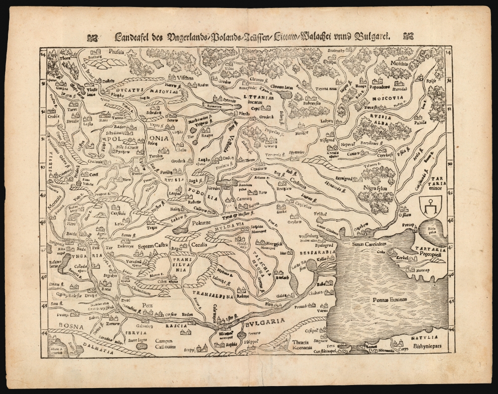
Landftafel des Ungerlands / Polands / Reüssen / Littaw / Walachei unnd Bulgarei.
1540 (undated) 10.5 x 13.5 in (26.67 x 34.29 cm) 1 : 1250000
1540 (undated) 10.5 x 13.5 in (26.67 x 34.29 cm) 1 : 1250000
Description
This is the 1564 German edition of Sebastian Münster's map of Poland and Hungary, the first acquirable map to focus on the region using contemporary place names and geographical knowledge.
The southern reaches are dominated by the River Danube: both Buda and Pest appear, as do the Carpathian Mountains of Transylvania. Bosnia, Serbia, and Bulgaria are illustrated along the southern shore of the Danube, whose broad delta is clear. Constantinople is included at the southern edge of the map. Tartaria, shown at the eastern extreme of the map, is marked with a heraldic shield bearing a stylized spur, a symbol Waldseemüller used on his 1507 world map to indicate the Tatar Empire, thus suggestive of one of Munster's sources - despite the present map outstripping Waldseemüller's treatment of the area in every respect.
Earlist Contemporary Map
Most earlier printed maps of the Poland/Hungary region were historical Ptolemaic maps of ancient Sarmatia. Martin Waldseemüller did issue a map in 1513, Tabula Moderna Sarmatie, but its scope was far broader and its content primitive. Münster's work drew somewhat on Bernard Wapowski's c. 1526 map of Sarmatia, but only fragments of that map have survived, making it unobtainable. Münster's map is thus the first obtainable map of this region featuring a recognizable Poland and Hungary.A Closer Look
The map's northern extents pertain to Poland and Prussia. The capital, Krakow, appears. The Duchy of Masovia, incorporated into Poland in 1526, is identified. The Duchy of Lithuania is depicted, but this map pre-dates the Polish-Lithuanian Commonwealth by 29 years. Muscovy appears at the eastern extent of the map. Smolensk, Moscow, Ryazan, and Kyiv are present.The southern reaches are dominated by the River Danube: both Buda and Pest appear, as do the Carpathian Mountains of Transylvania. Bosnia, Serbia, and Bulgaria are illustrated along the southern shore of the Danube, whose broad delta is clear. Constantinople is included at the southern edge of the map. Tartaria, shown at the eastern extreme of the map, is marked with a heraldic shield bearing a stylized spur, a symbol Waldseemüller used on his 1507 world map to indicate the Tatar Empire, thus suggestive of one of Munster's sources - despite the present map outstripping Waldseemüller's treatment of the area in every respect.
Publication History and Census
This map first appeared in Münster's 1540 edition of Ptolemy's Geographia and appeared in subsequent editions of that work and Münster's Cosmographia, with various typographical changes. This example corresponds typographically to the 1564 German edition of Cosmographia. The map appears separately in various institutional collections. Cosmographia is well represented in OCLC.CartographerS
Sebastian Münster (January 20, 1488 - May 26, 1552), was a German cartographer, cosmographer, Hebrew scholar and humanist. He was born at Ingelheim near Mainz, the son of Andreas Munster. He completed his studies at the Eberhard-Karls-Universität Tübingen in 1518, after which he was appointed to the University of Basel in 1527. As Professor of Hebrew, he edited the Hebrew Bible, accompanied by a Latin translation. In 1540 he published a Latin edition of Ptolemy's Geographia, which presented the ancient cartographer's 2nd century geographical data supplemented systematically with maps of the modern world. This was followed by what can be considered his principal work, the Cosmographia. First issued in 1544, this was the earliest German description of the modern world. It would become the go-to book for any literate layperson who wished to know about anywhere that was further than a day's journey from home. In preparation for his work on Cosmographia, Münster reached out to humanists around Europe and especially within the Holy Roman Empire, enlisting colleagues to provide him with up-to-date maps and views of their countries and cities, with the result that the book contains a disproportionate number of maps providing the first modern depictions of the areas they depict. Münster, as a religious man, was not producing a travel guide. Just as his work in ancient languages was intended to provide his students with as direct a connection as possible to scriptural revelation, his object in producing Cosmographia was to provide the reader with a description of all of creation: a further means of gaining revelation. The book, unsurprisingly, proved popular and was reissued in numerous editions and languages including Latin, French, Italian, and Czech. The last German edition was published in 1628, long after Münster's death of the plague in 1552. Cosmographia was one of the most successful and popular books of the 16th century, passing through 24 editions between 1544 and 1628. This success was due in part to its fascinating woodcuts (some by Hans Holbein the Younger, Urs Graf, Hans Rudolph Manuel Deutsch, and David Kandel). Münster's work was highly influential in reviving classical geography in 16th century Europe, and providing the intellectual foundations for the production of later compilations of cartographic work, such as Ortelius' Theatrum Orbis Terrarum Münster's output includes a small format 1536 map of Europe; the 1532 Grynaeus map of the world is also attributed to him. His non-geographical output includes Dictionarium trilingue in Latin, Greek, and Hebrew, and his 1537 Hebrew Gospel of Matthew. Most of Munster's work was published by his stepson, Heinrich Petri (Henricus Petrus), and his son Sebastian Henric Petri. More by this mapmaker...
Heinrich Petri (1508 - 1579) and his son Sebastian Henric Petri (1545 – 1627) were printers based in Basel, Switzerland. Heinrich was the son of the printer Adam Petri and Anna Selber. After Adam died in 1527, Anna married the humanist and geographer Sebastian Münster - one of Adam's collaborators. Sebastian contracted his stepson, Henricus Petri (Petrus), to print editions of his wildly popular Cosmographia. Later Petri, brought his son, Sebastian Henric Petri, into the family business. Their firm was known as the Officina Henricpetrina. In addition to the Cosmographia, they also published a number of other seminal works including the 1566 second edition of Nicolaus Copernicus's De Revolutionibus Orbium Coelestium and Georg Joachim Rheticus's Narratio. Learn More...
Bernard Wapowski (1475-1535) a Polish cartographer, is credited with the first contemporaneous map of Poland in 1526. He was born in Wapowce near Przemyśl, but virtually nothing is known of his early life. While in Rome as part of Erasme Ciołk's Polish Embassy between 1505 and 1506, he produced his first map of Poland. He enjoyed influence there, gaining introduction to the Pope and the protection of Cardinal Peirre Jules II. Wapowski stayed in Rome for several years at the Court of the Holy See where he worked on his map of Jagellonian Poland, based on Nicolas de Cuse's 1491 map. He is thought to have drawn the Ptolemaic maps covering Poland and Kievan Rus for the 1507 and 1508 Rome Ptolemies. By 1526 Wapowski was secretary to the King Sigismund the Old. At that time, he producd a map of Poland and the Grand Duchy of Lithuania with the assistance of Nicolaus Copernicus, with whom he studied at the University of Kraków under Albert Brudzewski. The 1526 map would be Wapowski's most important: it was the first large-scale, detailed, contemporaneous map of Poland. Wapowski's maps are now all lost except in a few surviving fragments. Despite this, his work was powerfully influential in the 16th century, providing the basis for the mapping of Poland and Hungary by Münster, Ortelius, Mercator and others. He is underdstood to have had assistance from Nicolaus Copernicus. The astronomer also learned from Wapowski during their longtime friendship, producing his own map of Prussia in 1510. Wapowski also wrote a continuation of Jan Długosz's History of Poland. Learn More...
Source
Munster, S. Cosmographey, (Basel: Petri) 1564.
The Cosmographia Universalis, one of the greatest geographical and historical works of the 16th century, 'taught nearly three generations of laymen most of what they knew about the world beyond their native places' (Strauss). Filled with maps, views, and rich descriptions of places throughout Europe and beyond, it was the best general source of geographical information until the advent of Ortelius' Theatrum. It was first issued by Sebastian Munster (1488 - 1552) in its 1544 German edition, and stayed in print long after its author's death in thirty five editions, and in five languages. (Of these, the 1550 and 1552 editions are widely regarded as the most complete and truest to the author's intentions: thereafter, later editors continued to add to the work's text; editions from 1588 onwards employed an entirely different set of maps produced on Ortelius' model.) Munster's goal, initially, was to rally his homeland's humanists and scholars to produce a new map of Germany in order to 'see what kind of a land our ancestors conquered for their home... bring honor to our country and place its beauties in the clear light of day.' Munster's project quickly expanded to cover the known world in its scope to produce a 'sufficiently large volume, in which I touch upon the foundation of all nations and kingdoms, their peculiarities, rivers, mountains, customs of men, royal successions, origins of the more important cities, succinct histories, religions, characteristics and fertility of lands... in Germany, however, I tarry a little longer'.
Munster's methodology in Cosmographia is notable in particular for his dedication to providing his readers with direct access to firsthand reports of his subjects wherever possible. Many of the maps were the result of his own surveys; others, the fruit of an indefatigable letter writing campaign to scholars, churchmen and princes throughout Europe, amicably badgering them for maps, views, and detailed descriptions of their lands. For lands further afield than his letters could reach, Munster relied on the best that the authorities of northern European scholarship could offer: he was well familiar with the work of Waldseemuller and other geographers of the early 16th century, and was well connected with the best geographers of his own generation. A disproportionate number of the maps of Cosmographia show contemporary geographical knowledge of the their respective areas for the very first time: The first map to show the continents of the Western Hemisphere; the first map to focus on the continent of Asia; the first modern map to name the Pacific Ocean; the first map to use a key; the first modern map of the British Isles and so on. Even in cases where earlier maps exist, Munster's works very often remain the earliest such acquirable by the collector.
Munster's methodology in Cosmographia is notable in particular for his dedication to providing his readers with direct access to firsthand reports of his subjects wherever possible. Many of the maps were the result of his own surveys; others, the fruit of an indefatigable letter writing campaign to scholars, churchmen and princes throughout Europe, amicably badgering them for maps, views, and detailed descriptions of their lands. For lands further afield than his letters could reach, Munster relied on the best that the authorities of northern European scholarship could offer: he was well familiar with the work of Waldseemuller and other geographers of the early 16th century, and was well connected with the best geographers of his own generation. A disproportionate number of the maps of Cosmographia show contemporary geographical knowledge of the their respective areas for the very first time: The first map to show the continents of the Western Hemisphere; the first map to focus on the continent of Asia; the first modern map to name the Pacific Ocean; the first map to use a key; the first modern map of the British Isles and so on. Even in cases where earlier maps exist, Munster's works very often remain the earliest such acquirable by the collector.
Condition
Very good. Marginal mend right of bottom centerfold just entering printed area with no loss.
References
Rumsey 11623.093. OCLC 228603857 (1545 issue).