This item has been sold, but you can get on the Waitlist to be notified if another example becomes available, or purchase a digital scan.
1690 Visscher / Sanson Map of Poland, Lithuania and Ukraine
PolandLithuania-visscher-1690$375.00

Title
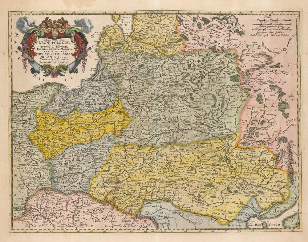
Tabula nova totius Regni Poloniae in quo sunt Ducatus et Provinicae Prussia, Cujavia, Mazovia, Russia Nigra etc. in qua Volhynia, et Podolia cum suis Palatinatibus ac Confinys.
1690 (undated) 16.5 x 21.75 in (41.91 x 55.245 cm) 1 : 3000000
1690 (undated) 16.5 x 21.75 in (41.91 x 55.245 cm) 1 : 3000000
Description
This is Nicolas Visscher II's beautiful 1690 map of the Polish Lithuanian Commonwealth, in a handsomely colored example.
Scope
The region mapped encompasses modern Poland, Lithuania, Latvia, Belarus, and Ukraine, spanning from the Baltic to the Black Sea. Mountains and forests are shown pictorially. Visscher's source - credited, beneath the scales - was Nicolas Sanson: specifically, the French mapmaker's 1655 Estats de la Couronne de Pologne ou sont les Royaume de Pologne… The richly engraved map features a shell-motif cartouche, hung with garlands, furs, and two Tatar bows and arrows, and is topped with two blowing wind-heads wearing fur caps.Publication History and Census
The map was engraved for inclusion in Visscher's 1690 Atlas minor. It is well represented in institutional collections and appears on the market from time to time.CartographerS
Nicolaes Visscher II (September 30, 1649 – May 31, 1702) was a Dutch engraver, cartographer and publisher: he was born into the trade, the son of Nicolaes Visscher I and the grandson of Claes Janszoon Visscher. He produced a number of maps to add to the family atlas, as well as for inclusion in other composite atlases. After his death, his wife, Elisabeth, continued the family tradition of mapmaking and publishing. The plates and remaining stock were then sold to Peter Schenk, who reprinted them under his own name. More by this mapmaker...
Nicolas Sanson (December 20, 1600 - July 7, 1667) and his descendants were the most influential French cartographers of the 17th century and laid the groundwork for the Golden Age of French Cartography. Sanson was born in Picardy, but his family was of Scottish Descent. He studied with the Jesuit Fathers at Amiens. Sanson started his career as a historian where, it is said, he turned to cartography as a way to illustrate his historical studies. In the course of his research some of his fine maps came to the attention of King Louis XIII who, admiring the quality of his work, appointed Sanson Geographe Ordinaire du Roi. Sanson's duties in this coveted position included advising the king on matters of geography and compiling the royal cartographic archive. In 1644, he partnered with Pierre Mariette, an established print dealer and engraver, whose business savvy and ready capital enabled Sanson to publish an enormous quantity of maps. Sanson's corpus of some three hundred maps initiated the golden age of French mapmaking and he is considered the 'Father of French Cartography.' His work is distinguished as being the first of the 'Positivist Cartographers,' a primarily French school of cartography that valued scientific observation over historical cartographic conventions. The practice result of the is less embellishment of geographical imagery, as was common in the Dutch Golden Age maps of the 16th century, in favor of conventionalized cartographic representational modes. Sanson is most admired for his construction of the magnificent atlas Cartes Generales de Toutes les Parties du Monde. Sanson's maps of North America, Amerique Septentrionale (1650), Le Nouveau Mexique et La Floride (1656), and La Canada ou Nouvelle France (1656) are exceptionally notable for their important contributions to the cartographic perceptions of the New World. Both maps utilize the discoveries of important French missionaries and are among the first published maps to show the Great Lakes in recognizable form. Sanson was also an active proponent of the insular California theory, wherein it was speculated that California was an island rather than a peninsula. After his death, Sanson's maps were frequently republished, without updates, by his sons, Guillaume (1633 - 1703) and Adrien Sanson (1639 - 1718). Even so, Sanson's true cartographic legacy as a 'positivist geographer' was carried on by others, including Alexis-Hubert Jaillot, Guillaume De L'Isle, Gilles Robert de Vaugondy, and Pierre Duval. Learn More...
Source
Visscher, Nicolas II, Atlas minor sive totius orbis terrarum contracta delinea ex conatibus Nico. Visscher, (Amsterdam: Visscher) 1690.
Condition
Excellent. Original color, refreshed.
References
OCLC 839119546. Rumsey 11755.016. Malinowski, H. The Malinowski Collection of Maps of Poland Part III in Map Collectors' Circle No. 43, Map # 413.