This item has been sold, but you can get on the Waitlist to be notified if another example becomes available, or purchase a digital scan.
1752 Vaugondy Map of Poland and Lithuania
Pologne-vaugondy-1757$225.00

Title
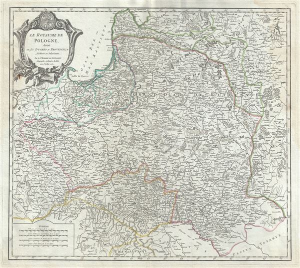
Le Royaume de Pologne, divise en ses duches et Provinces, et subdivise en Palatinats.
1752 (dated) 19.5 x 22.5 in (49.53 x 57.15 cm) 1 : 2400000
1752 (dated) 19.5 x 22.5 in (49.53 x 57.15 cm) 1 : 2400000
Description
This is a fine 1752 map of the Kingdom of Poland by Robert de Vaugondy. It depicts the different Palantinates or administrative division of Poland and Lithuania as well as parts of the Russian Empire, Transylvania and Latvia. The map renders the entire region in extraordinary detail offering both topographical and political information.
This map illustrates Poland in the declining years of the Polish-Lithuanian Commonwealth, prior to the 1772 First Partition of the Commonwealth. Following the death of King John III Sobieski and the end of Poland's Golden Age, a series of internal conflicts and external invasions destabilized the region to the brink of anarchy. The rapacious Russian Empire, under Tzar Peter the Great, used its influence to further weaken the state in anticipation of outright annexation. By 1768 the Polish-Lithuanian Commonwealth would become a protectorate of Imperial Russia.
A beautifully engraved title cartouche in the top left quadrant features the 'Pacta Conventa,' an agreement between the king and the Polish Nation reached at the beginning of each reign, from 1573 – 1764. The map was drawn by Robert de Vaugondy in 1752 and published in the 1757 issue of his Atlas Universel. The Atlas Universel was one of the first atlases based upon actual surveys. Therefore, this map is highly accurate (for the period) and has most contemporary town names correct.
Cartographer
Robert de Vaugondy (fl. c. 1716 - 1786) was French may publishing from run by brothers Gilles (1688 - 1766) and Didier (c. 1723 - 1786) Robert de Vaugondy. They were map publishers, engravers, and cartographers active in Paris during the mid-18th century. The father and son team were the inheritors to the important Nicolas Sanson (1600 - 1667) cartographic firm whose stock supplied much of their initial material. Graduating from Sanson's maps, Gilles, and more particularly Didier, began to produce their own substantial corpus. The Vaugondys were well-respected for the detail and accuracy of their maps, for which they capitalized on the resources of 18th-century Paris to compile the most accurate and fantasy-free maps possible. The Vaugondys compiled each map based on their own geographic knowledge, scholarly research, journals of contemporary explorers and missionaries, and direct astronomical observation. Moreover, unlike many cartographers of this period, they took pains to reference their sources. Nevertheless, even in 18th-century Paris, geographical knowledge was limited - especially regarding those unexplored portions of the world, including the poles, the Pacific Northwest of America, and the interiors of Africa, Australia, and South America. In these areas, the Vaugondys, like their rivals De L'Isle and Buache, must be considered speculative or positivist geographers. Speculative geography was a genre of mapmaking that evolved in Europe, particularly Paris, in the middle to late 18th century. Cartographers in this genre would fill in unknown lands with theories based on their knowledge of cartography, personal geographical theories, and often dubious primary source material gathered by explorers. This approach, which attempted to use the known to validate the unknown, naturally engendered rivalries. Vaugondy's feuds with other cartographers, most specifically Phillipe Buache, resulted in numerous conflicting papers presented before the Academie des Sciences, of which both were members. The era of speculative cartography effectively ended with the late 18th-century explorations of Captain Cook, Jean Francois de Galaup de La Perouse, and George Vancouver. After Didier died, his maps were acquired by Jean-Baptiste Fortin, who in 1787 sold them to Charles-François Delamarche (1740 - 1817). While Delamarche prospered from the Vaugondy maps, he defrauded Vaugondy's window Marie Louise Rosalie Dangy of her rightful inheritance and may even have killed her. More by this mapmaker...
Source
Robert de Vaugondy, G., Atlas Universel, (Paris: Antoine Boudet) 1757.
The Atlas Universel was the crowning glory of the Robert de Vaugondy firm's atlas production. The atlas was revolutionary on many levels and exemplified the Vaugondy credo commode, complet, univorme, et suive (convenient, complete, uniform, and easy to use). The atlas thus consisted of a wide corpus of maps, both modern and historical, was of moderate height and width, and featured maps of uniform style and structure. They partnered with Antoine Boudet, a shrewd businessman and publisher with whom they had worked previously, to produce the 1752 first edition. To minimize his fiscal risk, Boudet sold the atlas first by subscription using a large prospectus, receiving in the process over 1100 pre-orders. The first edition appeared in 1752 and contained beautifully produced maps with elaborate freshly designed allegorical cartouche work, generally by Pierre-Edme Babel, Pierre Philippe Choffard, and Charles Nicholas Cochin. Most of the maps were engraved by the Delahaye firm, the payment for whose services ultimately led to legal disputes. Despite proving a popular work of astounding quality, the Atlas Universal received harsh criticism from fellow cartographers, particularly Philipppe Buache. Ever at odds with the Vaugondys, Buache's critical perspective may have been influenced more by political maneuvering than academic affront. The atlas was issued in multiple editions between 1752 and 1788. Later editions, issued after 1786, were taken over by Charles Delamarche, who inherited the Robert de Vaugondy firm and assumed Boudet's publication rights.
Condition
Very good. Minor wear along original centerfold. Original platemark visible. Minor spotting and offsetting, with water stains in margins.
References
Rumsey 3353.071. Pedley, Mary Sponberg Belle et Utile: The Work of the Robert de Vaugondy Family of Mapmakers, 292.