This item has been sold, but you can get on the Waitlist to be notified if another example becomes available, or purchase a digital scan.
1851 Tallis and Rapkin Map of Polynesia
Polynesia-tallis-1851$100.00

Title
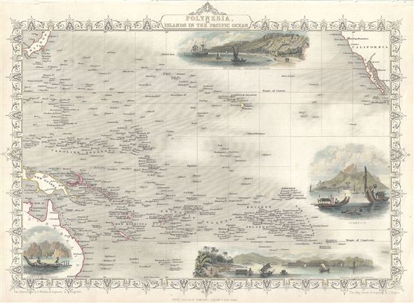
Polynesia or Islands in the Pacific Ocean.
1851 (undated) 10 x 12 in (25.4 x 30.48 cm) 1 : 42000000
1851 (undated) 10 x 12 in (25.4 x 30.48 cm) 1 : 42000000
Description
This is an impressive 1851 Tallis map of Polynesia or the Islands of the Pacific Ocean. It covers from Japan to California south as far as Australia and the Low Archipelago. Four inset views are included, featuring Resolution Bay, Marquesas, the Harbor of Dory, New Guinea, Otaheite and Kalakakooa, Sandwich Islands. The whole has a highly decorative presentation and the elaborate border distinctive of Tallis maps. The map was drawn and Engraved by J. Rapkin, with illustrations drawn by H. Winkles and engraved by T. Wrightson. This map was issued as part of the 1851 edition of John Tallis and Company's The Illustrated Atlas, And Modern History of the World.
Cartographer
John Tallis and Company (1838 - 1851) published views, maps, and atlases in London from roughly 1838 to 1851. Their principal works, expanding upon the earlier maps of John Cary and Aaron Arrowsmith, include an 1838 collection of London Street Views and the 1849 Illustrated Atlas of the World. The firm’s primary engraver was John Rapkin, whose name and decorative vignettes appear on most Tallis maps. Due to the embellishments typical of Rapkin's work, many regard Tallis maps as the last bastion of English decorative cartography in the 19th century. Although most Tallis maps were originally issued uncolored, it was not uncommon for 19th century libraries to commission colorists to "complete" the atlas. The London Printing and Publishing Company of London and New York bought the rights for many Tallis maps in 1850 and continued issuing his Illustrated Atlas of the World until the mid-1850s. Specific Tallis maps later appeared in innumerable mid to late-19th century publications as illustrations and appendices. More by this mapmaker...
Source
Tallis, J. and F., The Illustrated Atlas, And Modern History Of The World Geographical, Political, Commercial & Statistical, 1851.
Condition
Very good. Minor overall toning. Blank on verso.
References
Rumsey 0466.057. Phillips (Atlases) 804.