This item has been sold, but you can get on the Waitlist to be notified if another example becomes available, or purchase a digital scan.
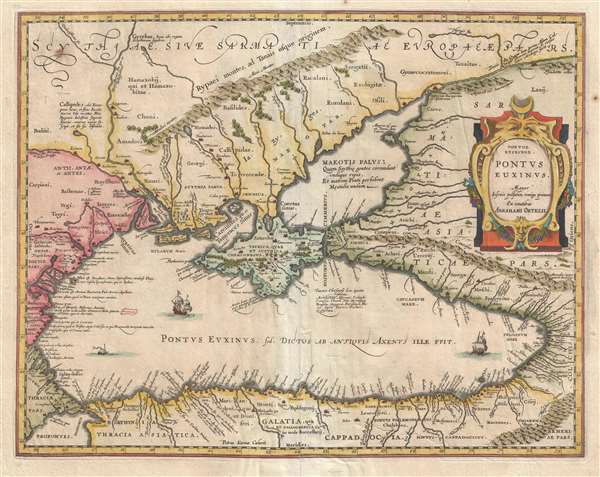
1601 Ortelius Map of the Black Sea and Vicinity (Turkey, Asia Minor, Crimea)
PontusEuxinus-Ortelius-1601$350.00

Title
Pontus Euxinus.
1601 (undated) 16 x 20 in (40.64 x 50.8 cm) 1 : 2700000
1601 (undated) 16 x 20 in (40.64 x 50.8 cm) 1 : 2700000
Description
This is a hand colored 1601 Abraham Ortelius map of the Black Sea and the surrounding region. The map depicts the Black Sea from Turkey, Romania, and Bulgaria on the left to Georgia, Russia, and Turkey on the right and from Ukraine and Crimea at the top to Turkey at the bottom. Ortelius here employs classical nomenclature. Turkey, for example, is divided into Cappadocia, Galatia, and Thrace and Ukraine and Crimea are Scythia. Cities and towns are depicted throughout the map, on the shore of the Black Sea or along one of the myriad rivers that run into the Black Sea. Three sailing ships are depicted in the Black Sea. Forests and mountains are depicted in profile.
This map was published as a part of Abraham Ortelius' Theatrum Orbis Terrarum in 1603 in Amsterdam.
This map was published as a part of Abraham Ortelius' Theatrum Orbis Terrarum in 1603 in Amsterdam.
Cartographer
Abraham Ortelius (April 14, 1527 - June 28, 1598) also known as Ortels, was a cartographer, geographer, and cosmographer of Brabant, active in Antwerp. He was the creator of the first modern atlas, Theatrum Orbis Terrarum and is a seminal figure in the history of cartography. Along with Gerard Mercator and Gemma Frisius, he was a founder of the Netherlandish school of cartography. His connections with Spain - culminating in his 1575 appointment as Royal Cartographer to King Phillip II of Spain - gave him unmatched access to Spanish geographical knowledge during a crucial period of the Age of Discovery. Ortelius was born in 1527 in Antwerp. In 1547 he entered the Antwerp Guild of Saint Luke as an illuminator of maps. He began trading in books, prints, and maps, traveling regularly to the Frankfurt book and print fair, where in 1554 he met Mercator. He accompanied Mercator on journeys throughout France in 1560 and it was at this time, under Mercator's influence, that he appears to have chosen his career as a scientific geographer. His first published geographic work appeared in 1564, an eight-sheet cordiform world map. A handful of other maps preceded the 1570 publication of the first edition of the Theatrum Orbis Terrarum, which would prove to be his life work. Appearing with but 53 maps in its first edition, Ortelius' work expanded with new maps added regularly. By 1592, it had 134 maps. Many of Ortelius' maps remained the standard for nearly a century. He traveled extensively, but his genius was as a compiler, locating the best informed maps on which to base his own. His contacts throughout Europe and extending even (via the Portuguese) to the Far East were formidable. Moreover, many of his maps were based on his own scholarship, particularly his historical works. His theories of geography were particularly ahead of his time with respect to the notion of continental drift, the possibility of which he mused on as early as 1596, and which would be proven correct centuries later.
In a sense his greatest achievement was his successful navigation of the religious and political violence endemic to his city throughout his adult life: The Dutch Revolt, or Eighty Years' War (1568 - 1648), fully embroiled Antwerp. Although outwardly and officially recognized as Catholic (Arias Montanus vouched for Ortelius' Catholic orthodoxy prior to his appointment as Royal Geographer), Ortelius was able to separate himself from the religious furor which characterized the war in the low countries. Ortelius showed a glimpse of himself in a letter to a friend, regarding humanist Justus Lipsius: 'I do not know whether he is an adherent of the Pope or a Calvinist, but if he has ears to hear, he will neither be one nor the other, for sins are committed on both sides'. Ortelius' own explorations of Biblical history in his maps, and the Christogram contained in his own motto, suggest him to be a religious man, but his abjuration of political religious authorities mark him as an individualist. His tombstone at St Michael's Præmonstratensian Abbey in Antwerp bears the inscription, Quietis cultor sine lite, uxore, prole. ('served quietly, without accusation, wife, and offspring.') More by this mapmaker...
Source
Ortelius, A., Theatrum Orbis Terrarum, (Amsterdam) 1603.
Condition
Very good. Repaired tears on verso. Light soiling. Blank on verso.
References
OCLC 224315462.