This item has been sold, but you can get on the Waitlist to be notified if another example becomes available, or purchase a digital scan.
1921 Shawcross City Map or Plan of Portland, Oregon
Portland-shawcross-1921$150.00

Title
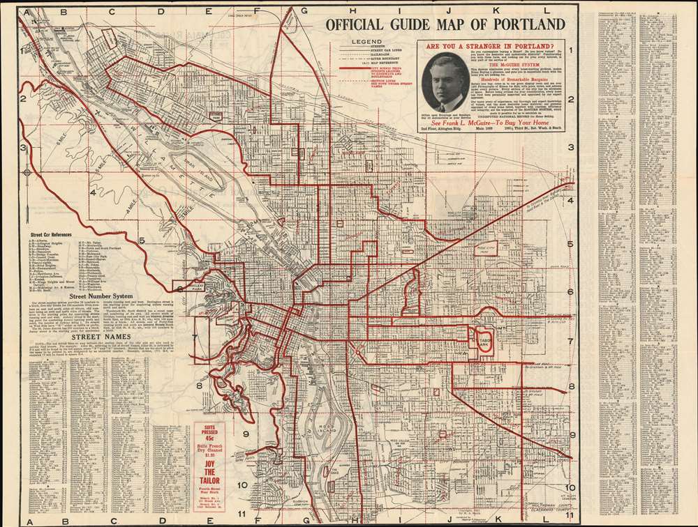
Official Guide Map of Portland.
1921 (dated) 21.125 x 27 in (53.6575 x 68.58 cm) 1 : 31680
1921 (dated) 21.125 x 27 in (53.6575 x 68.58 cm) 1 : 31680
Description
This is a 1921 Radford R. Shawcross city map or plan of Portland, Oregon. The map depicts the city from the West Oregon Lumber Company on the banks of the Willamette River to Mt. Scott Cemetery and from the Union Stock Yards to Clackamas County. Highly detailed, myriad streets throughout the city are illustrated labeled and an alphabetical street index is situated in the lower left corner and along the right border which provide the grid location of each street. Streetcar lines throughout the city are highlighted by thick black lines and marked by two letter abbreviations, with the references situated on the lower left as well. The bridges across the Willamette are all labeled, as are numerous companies along the river's banks, including shipyards, shipbuilders, iron works, lumber companies, and docks. The thick red lines mark scenic trips and thoroughfares leading to major highways and boulevards. Parks and cemeteries are also labeled. An advertisement for a realtor based in Portland is situated in the upper right corner next to the legend.
Publication History
This map was compiled by Radford R. Shawcross and published by M.A. Smith in 1921.Cartographer
Radford Richard Shawcross (November 29, 1886 - May 19, 1955) was an American civil engineer and cartographer. Born in Chicago, Illinois, Shawcross worked as a civil engineer in Oregon. He married May Elizabeth Fray on January 28, 1928 in Multnomah, Oregon. More by this mapmaker...
Condition
Very good. Even overall toning. Verso repairs to fold separations and at fold intersections. Exhibits slight loss along original fold lines. No bottom margin and close top margin. Text, road map of Oregon, and map of the Columbia River Highway on verso.