This item has been sold, but you can get on the Waitlist to be notified if another example becomes available, or purchase a digital scan.
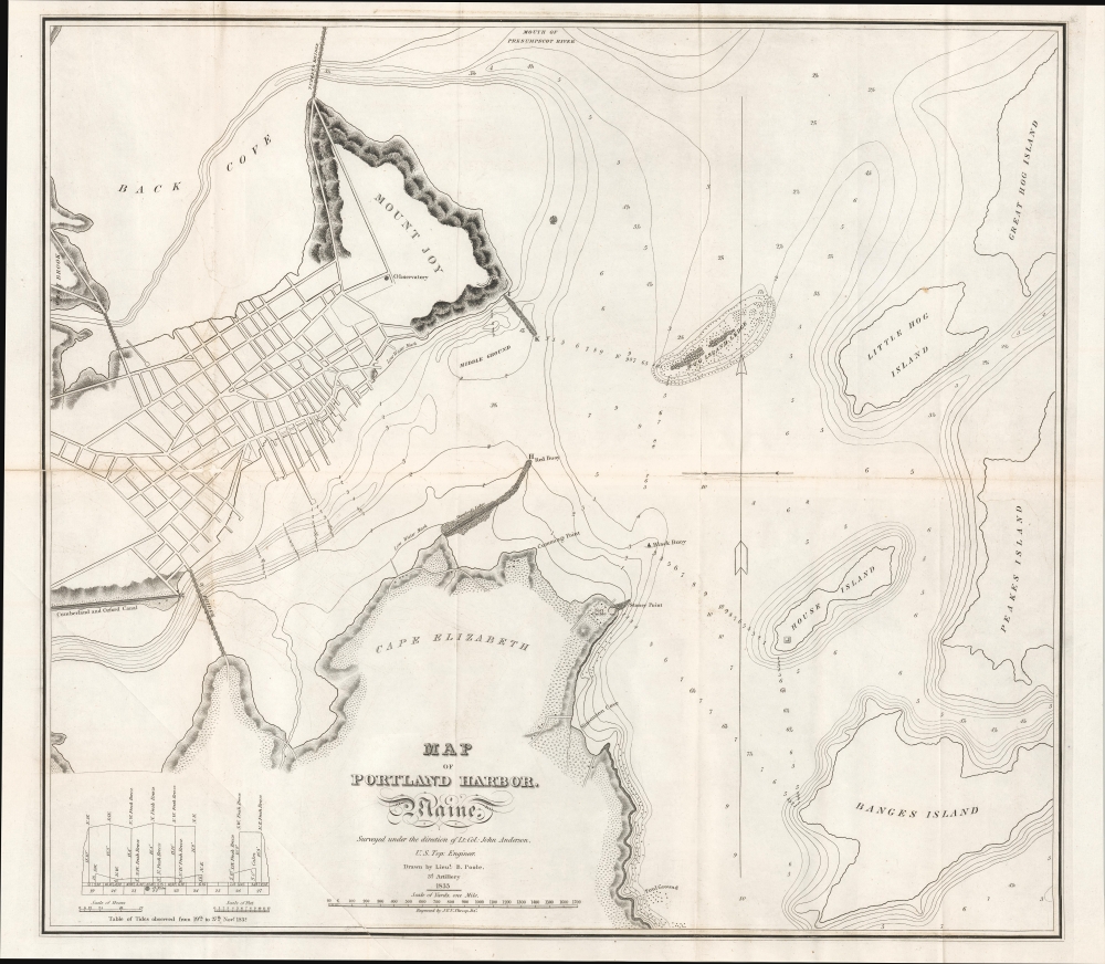
1833 Poole Nautical Chart of Portland Harbor, Maine
PortlandHarborMaine-poole-1833$200.00

Title
Map of Portland Harbor. Maine.
1833 (dated) 18.75 x 21.5 in (47.625 x 54.61 cm) 1 : 12240
1833 (dated) 18.75 x 21.5 in (47.625 x 54.61 cm) 1 : 12240
Description
This is an 1833 nautical chart of the harbor of Portland, Maine, produced for a congressional report on the harbor.
Although Portland (previously known as Falmouth) had been named the original capital of Maine upon statehood in 1820, it was moved to Augusta in 1832. However, Portland continued to be the state's main maritime and commercial center, especially once a rail link with Montreal was established in 1853, making Portland, a 'warm' water port, an important conduit for trade with Canada. At the time this chart was produced, Portland was considered a first-rate literary and cultural center, typified by the fascinating, idiosyncratic writer John Neal (1793 - 1876).
A Closer Look
The chart provides a fascinating glimpse at early 19th century Portland, resembling the geography of the area today but also demonstrating the changes in topography due to dredging, landfill, and other modifications in the intervening years. The city's nascent street grid is evident at the top-left, and some prominent landmarks, such as the Portland Observatory, a signal tower built in 1807, and Fort Preble, built in 1808, are labeled. Soundings, shoals, hazards, bridges, coves, points, buoys, low water marks, and other maritime features are named throughout. The Cumberland and Oxford Canal at left, completed in 1832, connected several large lakes in southern Maine with the Atlantic Ocean at Portland. A table of tides appears at bottom-left.Although Portland (previously known as Falmouth) had been named the original capital of Maine upon statehood in 1820, it was moved to Augusta in 1832. However, Portland continued to be the state's main maritime and commercial center, especially once a rail link with Montreal was established in 1853, making Portland, a 'warm' water port, an important conduit for trade with Canada. At the time this chart was produced, Portland was considered a first-rate literary and cultural center, typified by the fascinating, idiosyncratic writer John Neal (1793 - 1876).
Publication History and Census
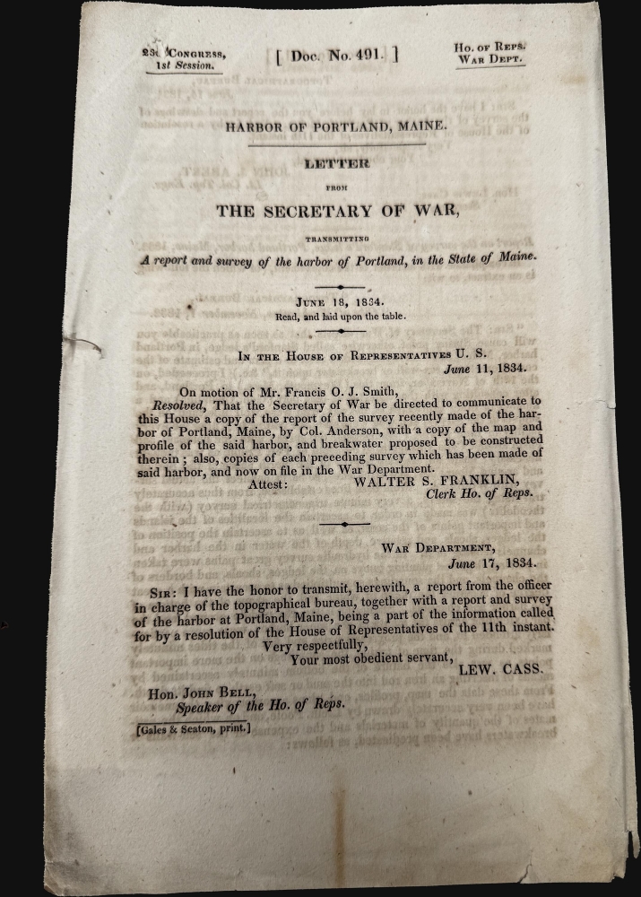
This chart was prepared in 1833 by Lieutenant B. Poole, an artillery officer, under the direction of Topographical Engineer John Anderson. It was engraved by John Van Ness Throop to accompany the 'Report of the Survey of Stanford's Ledge, Portland Harbor, Maine, 1832, Congressional Series 259 (23rd Congress, 1st Session) House Document.' The chart is quite rare, only noted among the holdings of the University of Texas at Arlington, the Osher Map Library at the University of Southern Maine, and the University of Maine at Orono.CartographerS
John Anderson (c. 1790 - 1834) was an early American military surveyor and a leading member of the nascent Corps of Topographical Engineers. Born in Connecticut, his family appears to have moved to Vermont in his childhood. After a year of study at Middlebury College, he entered the U.S. Military Academy at West Point in 1806 and graduated the following year, being appointed as an artilleryman. He was assigned to the Michigan Territory to survey a course for a road from Detroit to the Miami River in Ohio (later known as Hull's Road). Anderson appears to have left the military in 1811 but was called back to serve as the Chief of Bureau or senior topographer for a new Corps of Topographical Engineers formed in preparation for the War of 1812. He served as an artillery officer under Gen. Hull and was among those captured by the British at Detroit in December 1812, being briefly imprisoned in Canada afterwards and then paroled and returned to Washington, D.C., to which he carried Hull's account of the battle at Detroit and subsequent surrender. For the remainder of the war, Anderson worked as a topographer for the Army, including a return to the Detroit-Miami River road project. When the war with the British ended, the Corps of Topographers was disbanded, but Anderson and a Maj. Roberdeau were kept on to survey Lake Champlain and the northern frontier of the U.S. But in 1816, Congress established a small peacetime corps of military topographers. Anderson continued his work for the corps while residing in Detroit; he married in 1818 and became a prominent figure among the professional class in the growing city. From 1825 to 1833, he undertook coastal surveys for fortifications in New England as well as survey of the Hudson River. He then was tasked with surveys of a canal in southern Michigan and the coasts of Lake Huron, but he died in 1834, roughly a year after the death of his only child, John. Anderson's widow, Julia, survived him and, upon her death, bequeathed land and property to establish a Mariner's Church in Detroit (completed 1849), which still stands. For more information on Anderson, see the article by Rusty Davis, 'The Short Life of Colonel John Anderson of the US Topographical Engineers and His Impact on Early Michigan,' published in 2020 in the Michigan Historical Review. More by this mapmaker...
John Peter Van Ness Throop (April 15, 1794 - July 3, 1860), often as 'J.V.N. Throop,' not to be confused with contemporary politician John Peter Van Ness (1769 - 1846), was an engraver active in Washington, D.C. in the mid-19th century. Born in Chatham, New York, he was the son and grandson of Revolutionary War officers. It is unknown if he was related to fellow engraver Orramel Hinckley Throop, but it seems likely that they were are least distant relatives. J.V.N. Throop developed a niche as an engraver of illustrations and maps, especially nautical charts, in government documents and congressional reports. Learn More...
Source
'Report of the Survey of Stanford's Ledge, Portland Harbor, Maine, 1832', Congressional Series 259 (23rd Congress, 1st Session) House Document, (Washington D.C.) 1932.
Condition
Average. Stabilization and some infill along original fold lines, including verso repairs of split along centerfold from left margin to first fold intersection. Transference. Light foxing. Accompanies original Congressional report, 5 pages.
References
OCLC 55520526.