
1955 Civil Defense Hydrogen Bomb Detonation Evacuation Map of Portland, Oregon

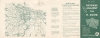
Your Guide for Defense Against the H-Bomb. Portland Target Area Evacuation Routes.
Evacuation Plan in the event of an H-bomb attack.
$950.00
Choose a Collection:
This Item
Enquire
Evacuation Plan in the event of an H-bomb attack.
This is a 1955 Civil Defense Cold War Era map of Portland, Oregon, illustrating evacuation plans in the event of a nuclear attack.Historical Context
As the largest city in the Pacific Northwest, Portland concentrated important transportation and industrial assets - river and deep-water port facilities, major bridges, rail yards, power infrastructure, and manufacturing and shipping businesses - marking it as a key target in any potential nuclear escalation of the Cold War (1947 - 1991). That reality fed city and statewide civil-defense efforts: air-raid drills at schools, fallout-shelter lists and signage, broadcast sirens and public information campaigns, and local preparedness committees that promoted evacuation and sheltering procedures.A Closer Look
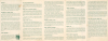
Centered on downtown Portland, the map depicts from North Plains, Hillsboro, and Newberg to Estacada and from Holbrook and Sauvie Island to Canby, Butteville, and Highland Store. Bold lines indicate evacuation routes, with arrows and text indicating the number of lanes available to evacuees on each route (either 2 or 4). Concentric circles mark the region 3, 6, 9, and 12 miles from downtown Portland. The text to the right provides an overview of essential information, continued on the verso.The Cold War
The Cold War was a geopolitical conflict between the United States and the Soviet Union, and their respective allies, the Western Bloc and Eastern Bloc, which began following World War II (1939 - 1945). The Cold War is generally considered to have started with the 1947 Truman Doctrine and ended with the 1991 dissolution of the Soviet Union. During the course of the conflict, both the United States and the Soviet Union developed powerful nuclear arsenals. While there was always a threat of nuclear war, the apocalyptic cost of such an exchange kept both sides from engaging in direct warfare. Instead, with no large-scale engagement, the Cold War was fought through various proxy wars, espionage, propaganda campaigns, embargoes, and psychological warfare. Each superpower supported major regional conflicts centered around an ideological and geopolitical struggle for global influence.Publication History and Census
This map was created and published by the local Civil Defense Organization in Portland. This piece is not cataloged in OCLC, and we have found only one other recorded instance of it appearing on the private market.Condition
Very good. Light wear along original fold lines. Light soiling. Text on verso. Dimensions given are for the entire sheet. The map itself measures 8 x 9.5 inches.