
1942 WWII German Propaganda Bombing Map of England


This item has been sold.
Die Grosse Englandkarte mit Nordfrankreich, Belgien und Holland.
Bombing Britain and a possible German invasion.
Choose a Collection:
- Digital Map Information
- Suitable for large format printing
- File Size: 37.96 MB
- File Type: ZIP / TIFF
- ICC color profile embedded
- Delivered instantly via download link
This Item
Enquire
Bombing Britain and a possible German invasion.
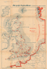
This is a 1942 German propaganda map of Great Britain published by Carl Lange Verlag during World War II (1939 - 1945). The map highlights cities throughout Britain that the Luftwaffe had bombed and reinforces the fact that Germany occupied the entire coast of continental Europe.A Closer Look
The map depicts from Connacht (here as Connaught), Ireland, to Norway and Mönchengladbach, Germany, and from the Shetland Islands to Chartres and Joinville, France. Red doughnut-shaped circles mark cities bombed by the German Luftwaffe throughout Britain and one in Ireland. Cities, towns, and villages are labeled throughout Britain.Bold red along the coast of continental Europe highlights areas occupied by the Germans, known as the 'Atlantic Wall'. The Channel Islands are also illustrated as being occupied by the Germans. This red also appears along Norway's coastline and between the Netherlands and Norway along the map's border. This inclusion can only mean that Lange wanted to emphasize that the Germans occupied Europe's coast from Brest all the way to Norway, including the parts of the continent not illustrated here. Cities and towns are labeled in Europe, along significantly fewer than those in Britain.
A German Invasion?
Red arrows point toward Britain from the entirety of Europe's coastline, declaring Germany's potential to invade the island nation. However, with the benefit of hindsight, we know that Germany could not have managed an invasion of Britain in 1942, or even earlier. Germany lost the Battle of Britain in 1940, and without aerial superiority over the English Channel, an invasion was not possible. Hitler elected to invade the Soviet Union instead and launched Operation Barbarossa on June 22, 1941. The Nazi Army got bogged down in the east, and even if the Luftwaffe had managed to defeat the British Royal Air Force, they would not have been able to continue fighting the Russians and invade Britain. Thus, these arrows are the propaganda aspect of this piece. This map was intended to convince the German people that an invasion of Britain was still a viable option. It also must have been meant to show the Germans that, even though they were being bombed night and day by the Royal Air Force and the American Army Air Force, the Luftwaffe was returning that violence in kind by bombing German cities. Ironically, the German phrase 'Ohne Gewähr!' appears below the border at the center, which translates to 'Without Guarantee!'. A surprising phrase to find at the bottom of a piece of propaganda.Publication History and Census
This map was created and published by Carl Lange Verlag in Duisburg, Germany, in 1942. It is not cataloged in OCLC, and we have not found any records of it in institutional collections. We note only a couple of instances when it has appeared on the private market.Condition
Good. Wear along original fold lines. Soiling. A few small areas of infill. Name written in ink in upper margin.