This item has been sold, but you can get on the Waitlist to be notified if another example becomes available, or purchase a digital scan.
1909 Walker Bird's-Eye View Map of Portland Railroad System, Maine
PortlandRR-walker-1909$925.00

Title
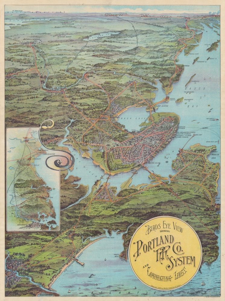
Birds Eye View Showing Portland R.R. Co. System and Connecting Lines.
1909 (dated) 27.75 x 20.75 in (70.485 x 52.705 cm)
1909 (dated) 27.75 x 20.75 in (70.485 x 52.705 cm)
Description
A striking 1909 George Walker chromolithograph view of Portland, Maine, and the Portland Railroad System - really more of a combined streetcar, train, and trolley system. This view is the rarest and perhaps most beautiful of Walker's 'Trolley Wayfinder' views.
A Closer Look
Centered on Portland, the view embraces the Maine coast from Saco to Bath, and inland to include Sabago Lake. The view was issued to promote the Portland R.R. system and that companies likes are accordingly emphasized in red. An inset at left details routes south to Portsmouth, New Hampshire. The areas to the south of Portland, including Saco, Old Orchard Beach, Cape Elizabeth, and South Portland are exceptionally detailed.Portland R.R. Company
The Portland Railroad Company of Maine was a significant street railway operation in the late 19th and early 20th centuries. By 1909, it was part of the extensive trolley network that connected many towns and cities in New England. The company was notable for its operation in and around the Portland area, including links to nearby towns and popular local destinations. Like many trolley systems of that era, the Portland Railroad Company faced competition from automobiles and buses in the 20th century. By the 1930s, the rise of the automobile and the economic constraints of the Great Depression led to a decline in ridership and its eventual demise.Walker's Wayfinder Views
This style of map, incorporating trolley lines with a bird's-eye view and stunning chromolithography, first appeared in 1904 with the issue of Walker's stunning Trolley Wayfinder Birds Eye View of Trolley Routes in New England (1904-lane- TrolleyRoutesNewEngland). The style became popular, with other similar maps following, including depictions of the New York area, Long Island, the Mid-Atlantic States, and the vicinity of Chicago. Most were published by Walker and embraced a similar style, color palette, and overall esthetic. In general, they were sold and passed out as souvenirs on the depicted trains, trolleys, and ferries.Chromolithography
Chromolithography, sometimes called oleography, is a color lithographic technique developed in the mid-19th century. The process involved using multiple lithographic stones, one for each color, to yield a rich composite effect. Oftentimes, the process would start with a black basecoat upon which subsequent colors were layered. Some chromolithographs used 30 or more separate lithographic stones to achieve the desired product. Chromolithograph color could also be effectively blended for even more dramatic results. The process became extremely popular in the late 19th and early 20th centuries when it emerged as the dominant method of color printing. The vivid color chromolithography produced made it exceptionally effective for advertising and propaganda.Publication History and Census
This view was produced and printed by George Walker Lithography of Boston in 1909. There is only one known edition. It is rare, with OCLC recognizing only two holdings: The Osher Map Library and the Southern Methodist University DeGolyer Library. No history on the private market.Cartographer
George Hiram Walker (January 4, 1852 - November 14, 1927) was a Boston based publisher of books, views, and maps active in the late 19th and early 20th centuries. Born in Springfield, Vermont, Walker started his life as a dry goods merchant but developed an active interest in publishing during the early 1870s. Walker began publishing in 1878 when he partnered with an unknown New York Firm. Two years later, Walker brought the operation in house by partnering with his brother, Oscar W. Walker, in the opening of a lithography studio at 81 Milk Street, Boston. Shortly thereafter the firm expanded to new offices at 160 Tremont Street, Boston. The Walker brothers produced a large corpus of works, most of which focused on travel and tourism in New England. Walker also established the Walker-Gordon Milk Laboratory with Dr. Thomas Morgan Rotch and Gustave Gordon. This interesting investment was based on the premise that infant deaths could be avoided by providing higher quality milk. The company eventually became a great success, producing a high-quality cow milk that closely resembled human breast milk. In the process the Walker-Gordon laboratory developed many of the dairy health standards that are still with us today. Walker married Irene L. Loud on March 25, 1885. More by this mapmaker...
Condition
Very good. Some fading. A few minor verso reinforcements on fold intersections.
References
OCLC 64282127. Osher Map Library, OS-1909-29. Library of Congress, G3731.P3 W3 1909.