1850 Henry Walling Wall Map of Portsmouth, New Hampshire
PortsmouthNH-walling-1850$2,750.00

Title
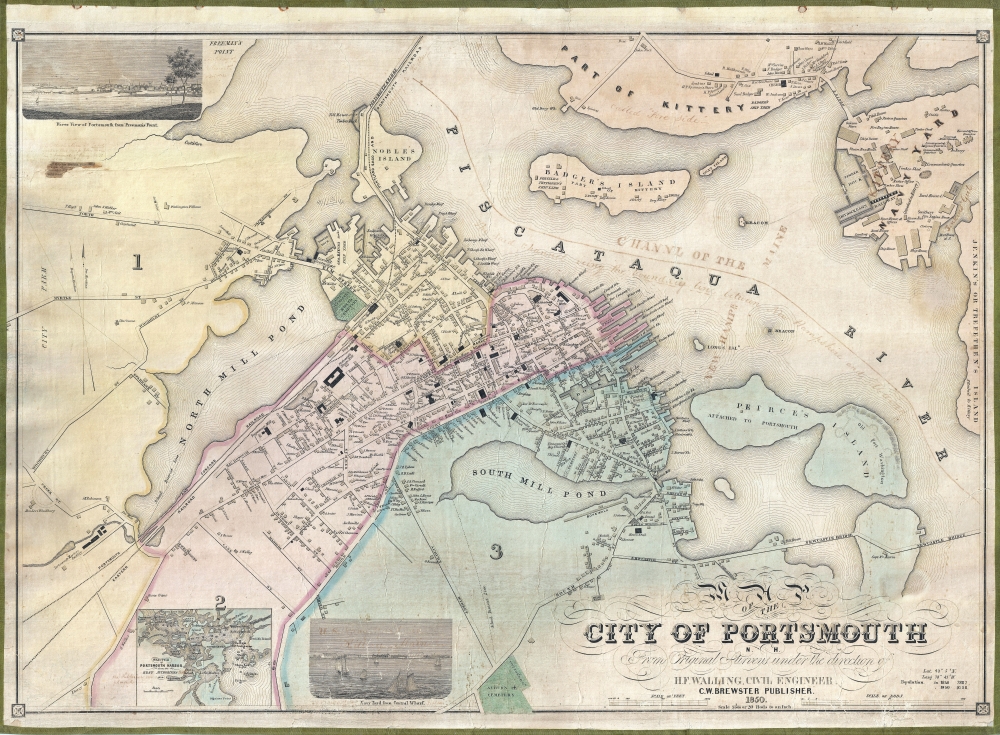
Map of the City of Portsmouth N. H. From Original Surveys Under the Direction of H. F. Walling, Civil Engineer.
1850 (dated) 25 x 33.75 in (63.5 x 85.725 cm) 1 : 3960
1850 (dated) 25 x 33.75 in (63.5 x 85.725 cm) 1 : 3960
Description
A scarce 1850 Henry Francis Walling map of Portsmouth, New Hampshire, and Kittery, Maine. Walling began publishing separately issued town plans on his own account in 1850, making this one of his earliest maps. Moreover, of Walling's nearly 150 separately issued town plans, this is one of the largest scale and most highly detailed.
A Closer Look
With a scale of 1: 3960, Walling meticulously maps nearly every building in both Portsmouth and Kittery, many of which are labeled according to the property owner. Civil, religious, and government buildings are distinguished from residential properties by being rendered as darker blocks. Several sites are of note, such as Frederick Fernald and William Pettigrew's Shipyard on Badger's Island (established 1844), the Portsmouth Athenaeum, Brick Market, the Boston and Portland Railroad Depot, and more. The Kittery Navy Yard is exceptionally well delineated, with buildings noted according to location and purpose. There are two vignettes, one a River view of Portsmouth from Freeman's Point, and another view of the Navy Yard from Central Wharf. An inset map appears in the lower left detailing the Portsmouth Harbor vicinity (1 : 80000). This map has several manuscript annotations, most of which are faded. These include the identification of the Main-New Hampshire border on the Piscataqua River, notations in Kittery, and an unreadable annotation in the upper right, as well as several smaller notes.Publication History and Census
This map was drawn by Henry F. Walling based upon earlier survey work supplemented by Walling's own surveys. It was published by Charles Warren Brewster in 1850, in the same year that representatives met to write New Hampshire's Constitution, suggesting that Brewster, who was a member of the Constitutional Committee, may have published this to capitalize on feelings of regional pride and New Hampshire solidarity. We note 6 examples cataloged in OCLC: the University of Michigan, Harvard University, Dartmouth College, the Osher Map Library at the University of Southern Maine, the FamilySearch Library in Salt Lake City, and the Las Vegas Nevada FamilySearch Library. We are aware of 3 additional examples in private hands.CartographerS
Henry Francis Walling (June 11, 1825 - April 8, 1889) was an American civil engineer, cartographer, surveyor, and map publisher active from the middle to late 19th century. Walling was born in Providence, Rhode Island. He studied/worked at the Providence Athenaeum before discovering a talent for mathematics and surveying. Walling took a position with Samuel Barrett Cushing (1846 - 1888), a Providence-based civil engineer with whom he issued in 1846 a revision of James Steven's Topographical Map of the State of Rhode-Island. Walling established himself independently around 1850 and immediately began preparing a series of town plans focusing on Bristol County, near Providence. Buoyed by widespread interest in his plans, Walling expanded his operations to Massachusetts, where, by 1857, he had produced no less than 50 town plans. Apparently, Walling's business model involved a contract with town officials to produce a certain number of maps, after which he acquired the right to print and sell additional copies on his own account. This work eventually led to Walling's appointment as Massachusetts "Superintendent of the State Map", a designation that began appearing on his maps around 1855. While Walling's work focused heavily on city and county maps, he successfully published three scarce state maps: Maine, Vermont, and Rhode Island. In 1856, Walling relocated his headquarters to New York City, where he had better access to quality lithographers. The Civil War (1861 - 1865) proved difficult for Walling, and diminished sales may have forced him into a partnership with Ormando W. Gray, with whom he published numerous state, county, and national atlases in the 1860s and 1870s. Around 1880, Walling took a post with the U.S. Coast Survey, with whom he worked on various charts until requesting a transfer in 1883 to the newly formed U.S. Geological Survey. Walling remained with the Geological Survey until his untimely death of a heart attack in April 1889. More by this mapmaker...
Charles Warren Brewster (September 13, 1802 – August 3, 1868) was a Portsmouth, New Hampshire, based printer and writer active in the first half of the 19th century. Brewster was born in a distinguished New Hampshire family and can trace his ancestry to Elder William Brewster, a passenger on the Mayflower. As a young man, Brewster apprenticed in the offices of the Portsmouth Journal. He took over the journal in 1838 and continued to publish the paper for more than 50 years. Brewster served several terms as a Whig in the New Hampshire Legislature and was a participant in the 1850 – 1851 New Hampshire State Constitutional Convention. Brewster's most influential work is his volume of local character sketches, Rambles About Portsmouth. Learn More...
Condition
Very good. Professionally restored and laid down on fresh linen.
References
OCLC 557059776, 22755503. Cobb, D. A. New Hampshire Maps to 1900: An annotated Checklist, #193. New Hampshire Historical Society, 912.778b P853br. Harvard Map Colleciton, HOLLIS 009607170. #183.