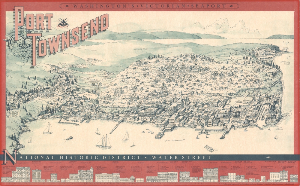
1982 Schumacher Pictorial View of Port Townsend, Washington
PortTownsend-schumacher-1982$800.00


Title
Port Townsend, Washington's Victorian Seaport.
1982 (dated) 21.25 x 34.5 in (53.975 x 87.63 cm)
1982 (dated) 21.25 x 34.5 in (53.975 x 87.63 cm)
Description
A charming large-format pictorial view of Port Townsend, Washington, drawn by Sharon Schumacher in 1982. It combines historical information about the town with more common features of contemporary pictorial maps, especially the labeling of local businesses (presumably sponsors of the view's production).
A Closer Look
Oriented towards the northwest, the view looks out over the historic district of the town, with the Salish Sea / Juan de Fuca Strait in the background. It presents an interesting combination of styles, with the title text and illustration of buildings being reminiscent of late 19th century town views, but with many local businesses labeled, as was common with pictorial maps of the 1980s. In addition to local businesses, landmarks such as parks, churches, government offices, a golf course, and the town's distinctive bell tower are noted throughout. Historical buildings, especially grand mansions dating to the late 19th century, are also indicated. At bottom is a profile of the buildings and businesses of Water Street, a National Historic (Landmark) District.Local History
Port Townsend is an excellent natural harbor at the entrance of Puget Sound. It was therefore inhabited by European-American settlers early, relative to other nearby areas, being incorporated as a town in 1851 (then part of the Oregon Territory). It developed quickly, resulting in the town's distinct architecture, celebrated in this view, and was even considered to be a contender for becoming the main port in the American West. Although it did not quite reach that distinction (it was hurt by the Northern Pacific Railway's decision to terminate on the eastern side of Puget Sound rather than the western side), it was a very active seaport throughout the second half of the 19th century. The town's fortunes have varied since but have improved in recent decades as its well-preserved historic district has attracted tourists and even new residents.Publication History and Census
This view was designed by Bernardo Pebenito, illustrated by Sharon Schumacher, and produced by Marketing Concepts Unlimited in conjunction with MPC Services, Inc. in 1982. It has no known presence in institutional collections nor known history on the market.Cartographer
Sharon Schumacher (fl. c. 1980 - 1988) was an artist and producer of pictorial maps active in the early 1980s. Her work focused on the Pacific Northwest and Alaska. More by this mapmaker...
Condition
Very good. Slight wear along edge.