This item has been sold, but you can get on the Waitlist to be notified if another example becomes available, or purchase a digital scan.
1579 Ortelius Map of Portugal ( Porvgalliae )
Portugalliae-ortelius-1587$675.00

Title
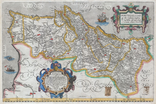
Portvgalliae que olim Lusitania, novissima & exactissima descriptio, Aucto re Vernando Aluaro Secco (A very new & exact depiction of Portugal, once called Lusitania, by Vernandus Alvarus Secco).
1579 (undated) 15.5 x 20 in (39.37 x 50.8 cm)
1579 (undated) 15.5 x 20 in (39.37 x 50.8 cm)
Description
A rare and beautiful 1579 Abraham Ortelius map of the Kingdom of Portugal. Follows the extremely rare two sheet Alavaraz Secco map published by Michele Tramezzino in 1561. North oriented to the right. Sea decorated with monsters and sailing ships. Bottom right features two hand drawn heraldic emblems, a rather unique variation on this map. Features two elaborate cartouches in the top right and bottom left. Top right cartouche contains the map title in Latin, translated above. Bottom left cartouche include the following roughly translated text: Achilles Statius salutes Guido Ascanius Sfortia, S.R.E. Card. Camer. With dedication the Lusitania of Vernandus Alvarus has been depicted for you, Guido Sfortia, because we call it the protectorate of our people: from here men have sailed out with incredible courage in foul and fair. They have frequented all parts of the world. They added a large part of Africa to our country; countless is the number of islands, known only by name or not even that, because they had no name, which they first discovered and took in their possession. The most fair lands of Asia they have made tributaries; the most distant lands they taught the service and religion of Jesus Christ. Fare thee well. Rome, on the 13th day of the Calends of June, in the year 1560. Approximately 250 impressions of this exact state were printed. Approximately 8175 copies of this map, in various states, were printed from roughly 1570 to 1641. Most have been lost or destroyed. A very rare map.
Cartographer
Abraham Ortelius (April 14, 1527 - June 28, 1598) also known as Ortels, was a cartographer, geographer, and cosmographer of Brabant, active in Antwerp. He was the creator of the first modern atlas, Theatrum Orbis Terrarum and is a seminal figure in the history of cartography. Along with Gerard Mercator and Gemma Frisius, he was a founder of the Netherlandish school of cartography. His connections with Spain - culminating in his 1575 appointment as Royal Cartographer to King Phillip II of Spain - gave him unmatched access to Spanish geographical knowledge during a crucial period of the Age of Discovery. Ortelius was born in 1527 in Antwerp. In 1547 he entered the Antwerp Guild of Saint Luke as an illuminator of maps. He began trading in books, prints, and maps, traveling regularly to the Frankfurt book and print fair, where in 1554 he met Mercator. He accompanied Mercator on journeys throughout France in 1560 and it was at this time, under Mercator's influence, that he appears to have chosen his career as a scientific geographer. His first published geographic work appeared in 1564, an eight-sheet cordiform world map. A handful of other maps preceded the 1570 publication of the first edition of the Theatrum Orbis Terrarum, which would prove to be his life work. Appearing with but 53 maps in its first edition, Ortelius' work expanded with new maps added regularly. By 1592, it had 134 maps. Many of Ortelius' maps remained the standard for nearly a century. He traveled extensively, but his genius was as a compiler, locating the best informed maps on which to base his own. His contacts throughout Europe and extending even (via the Portuguese) to the Far East were formidable. Moreover, many of his maps were based on his own scholarship, particularly his historical works. His theories of geography were particularly ahead of his time with respect to the notion of continental drift, the possibility of which he mused on as early as 1596, and which would be proven correct centuries later.
In a sense his greatest achievement was his successful navigation of the religious and political violence endemic to his city throughout his adult life: The Dutch Revolt, or Eighty Years' War (1568 - 1648), fully embroiled Antwerp. Although outwardly and officially recognized as Catholic (Arias Montanus vouched for Ortelius' Catholic orthodoxy prior to his appointment as Royal Geographer), Ortelius was able to separate himself from the religious furor which characterized the war in the low countries. Ortelius showed a glimpse of himself in a letter to a friend, regarding humanist Justus Lipsius: 'I do not know whether he is an adherent of the Pope or a Calvinist, but if he has ears to hear, he will neither be one nor the other, for sins are committed on both sides'. Ortelius' own explorations of Biblical history in his maps, and the Christogram contained in his own motto, suggest him to be a religious man, but his abjuration of political religious authorities mark him as an individualist. His tombstone at St Michael's Præmonstratensian Abbey in Antwerp bears the inscription, Quietis cultor sine lite, uxore, prole. ('served quietly, without accusation, wife, and offspring.') More by this mapmaker...
Condition
Very good condition. Minor expert repair on certerfold approximately 4 inches below the border. Wide clean margins. Original platemark. Latin text on verso.
References
Marcel van den Broecke No. 26. ; Meurer p. 234 ; Karrow 67/1 p. 472-474.