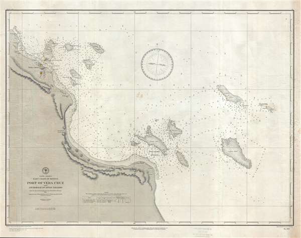
1891 U.S. Navy Hydrographic Office Nautical Chart of Port of Veracruz, Mexico
PortVeraCruz-hydrographic-1891$450.00

Title
Port of Vera Cruz and Anchorage of Anton Lizardo.
1891 (dated) 23.25 x 31 in (59.055 x 78.74 cm) 1 : 59000
1891 (dated) 23.25 x 31 in (59.055 x 78.74 cm) 1 : 59000
Description
This is an 1891 U.S. Navy Hydrographic Office nautical chart or maritime map of the port of Veracruz, Mexico and the anchorage of Anton Lizardo. The map depicts the coastline of Mexico from Point Gorda to Anton Lizardo and further south. Several points along the coast are labeled, including Veracruz, Vergara, the mouth of the Medellin River, and several points. Veracruz is depicted in detail, with individual buildings rendered along with the piers in the port and the city's fortifications. The Castle of San Juan de Ulloa is illustrated in its emplacement across the bay from Veracruz. A note is included that moles are under construction at Veracruz and that the northern entrance to the city is closed. The Anton Lizardo Anchorage is also labeled, along with several reefs which lay off the coast of both Vera Cruz and Anton Lizardo. Myriad depth soundings are indicated, with depths noted in fathoms. In the lower left corner, next to the title, a table bears information about lights along the coastline, two of which are located at convents.
This map was issued on September 15, 1891, per a stamp located on the bottom margin, by the Hydrographic Office.
This map was issued on September 15, 1891, per a stamp located on the bottom margin, by the Hydrographic Office.
Cartographer
United States Hydrographic Office (1866 - 1962) was a brach of he U.S. Navy that prepared and published maps, charts, and nautical books to aid in navigation. Before the establishment of the Hydrographic Office in 1866, U.S. navigators were almost entirely dependent on British charts. There had been a few private enterprises that had prepared and published charts, but none had been able to do so profitably. The Office was established 'for the improvement of the means of navigating safely the vessels of the Navy and of the mercantile marine, by providing, under the authority of the Secretary of the Navy, accurate and cheap nautical charts, sailing directions, navigators, and manuals of instructions for the use of all vessels of the United States, and for the benefit and use of navigators generally.' This way the Navy Department could furnish navy and merchant ships with charts illustrating the results of surveys and explorations undertaken by naval officers. The charts were priced to cover the cost of paper and printing alone, not preparation. Its main objective was to survey foreign coasts, as the Coast and Geodetic Surveys were responsible for surveying domestic waters. The Hydrographic Office was transferred from the Department of the Navy to the Department of Defense in 1949 and was replaced by the Naval Oceanographic Office in 1962. More by this mapmaker...
Condition
Very good. Heavy soiling along right border. Blank on verso.