This item has been sold, but you can get on the Waitlist to be notified if another example becomes available, or purchase a digital scan.
1879 Imperial German General Post Office Map of Overseas Mail Steamship Lines
PostalRoutes-imperialgerman-1879$275.00

Title
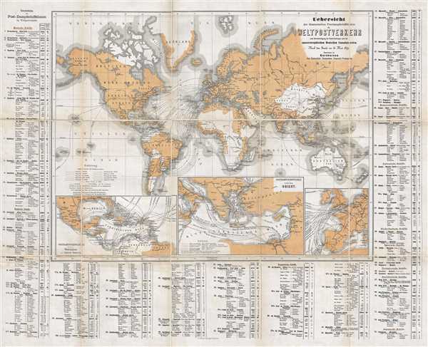
Uebersicht der überseeischen Postdampfschiffslinien im Weltpostverkehr unter Berücksichtigung der Postverbindungen nach den aussereuropäischen Deutschen Consulatsorten.
1879 (dated) 24 x 31 in (60.96 x 78.74 cm) 1 : 47140000
1879 (dated) 24 x 31 in (60.96 x 78.74 cm) 1 : 47140000
Description
This is an 1879 Imperial German General Post Office map of world postal routes. The map depicts the world from Hawaii (the Sandwich Islands) to New Zealand and from the Arctic Ocean to Tierra del Fuego. Seventy-three different steamship routes are illustrated, each of which is numbered and corresponds to a route in the index situated along the left and right sides and along the bottom. Routes are distinguished by nation, with German, English, French, Austrian, Italian, Dutch, Spanish, Portuguese, American, and Japanese routes each illustrated using different symbols. Railroads and overland postal routes via highways are also depicted.
Two different colors are employed on this map, tan and white. The tan represents the countries that are members of the Universal Postal Union (UPU). The Universal Postal Union was established by the Treaty of Bern of 1874 and established that there should be a universal flat rate to mail a letter anywhere in the world, that postal authorities should give equal treatment to foreign and domestic mail, and that each country should retain all money it has collected for international postage. Due to the UPU, it became unnecessary to affix the stamps of any country through which one's letter or parcel would pass in transit to its destination. The UPU provides that stamps of member nations are accepted throughout the international mail system. Member states of the UPU depicted here are shaded a tan color, while non-member states are white.
Three inset maps are situated along the bottom border, each illustrating a region of the world where greater focus allowed for a better understanding of the complicated postal routes. On the left, an inset map of the West Indies and Central America allows for a clearer understanding of the intertwined routes in this part of the world, which were jumbled together on the larger map. The inset map in the middle focuses on the eastern Mediterranean, a small, but very important, part of the world that includes Constantinople, Cairo, and Naples. By creating an inset map for this region, the cartographers allowed for a clearer picture of the postal routes in this part of the world. Western Europe and the eastern Atlantic Ocean are the focus of the inset map situated on the right. An entangled web of lines on the larger map, this inset illuminates a very cluttered part of the world and shines a light on the complexity of transatlantic and intereuropean mail routes.
This map was produced by the Imperial German General Post Office in 1879.
Condition
Very good. Dissected into 18 panels and mounted on linen. Blank on verso.