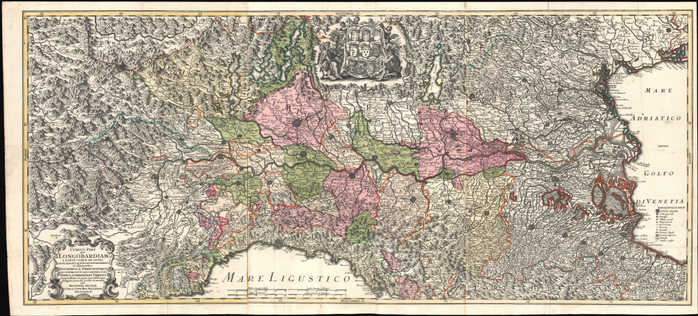
1734 Seutter Three-Sheet Map of the Po River Valley, Northern Italy
PoValley-seutter-1734$2,400.00


Title
Cursus Padi per Longobardiam a Fonte usque a ostia cum fluminibus que in illum se exonerant et adjacentibus Ducatibus ac Principatibus quos interluit et qui confinis sunt, Tribus Combinandis tabellis...
1734 (undated) 23 x 52 in (58.42 x 132.08 cm) 1 : 540000
1734 (undated) 23 x 52 in (58.42 x 132.08 cm) 1 : 540000
Description
This is Mattheus Seutter's stunning c. 1734 large-scale three-sheet map of the Po River Valley, covering much of northern Italy. The map was issued during the War of the Polish Succession (1733 - 1735). It does not reflect struggles in Poland directly but rather the wider strategic struggle between France and Austria for dominance in Europe and Italy.
This effort failed but was not so thoroughly defeated as to prevent a succession crisis when Augustus II died, leading contesting factions of the Polish nobility backed by various foreign powers to hold contesting elections, resulting in two rival claims to the throne: Augustus II's son Augustus III (r. 1733 - 1763) and Stanisław Leszczyński. The Habsburgs, Russia, and Prussia fell behind Augustus, giving him a commanding position in Poland itself, while France and Spain backed Stanisław, giving the anti-Habsburg forces the upper hand in central and western Europe. Thus, the Russians quickly occupied Warsaw and Augustus was installed on the throne, while the Bourbons and their allies made some headway in the Rhineland and significant gains in Italy (French allies included the Duchy of Savoy, the Kingdom of Sardinia, and Duchy of Parma).
In northern Italy, the anti-Habsburg forces won a series of victories but failed to properly exploit them (such as with the Battle of Guastalla on September 19, 1734 marked here), giving the Austrians an opportunity to regroup. While the Bourbons and their allies fell into infighting and their armies began to face attrition from disease, cold, and desertion, they were forced to retreat, resulting in an inconclusive campaign. In southern Italy, the Bourbons saw spectacular success in conquering the Kingdom of the Two Sicilies. Thus, the contours of a postwar settlement became quickly apparent, mostly confirming several faits accomplis; Augustus III was confirmed as King of Poland, Bourbon rule was confirmed in southern Italy, and Austrian/Habsburg power was strengthened in northern Italy.
A Closer Look
Coverage includes a swathe of northern Italy between the French Alps and Venice centered on the Po River, including the cities of Genoa, Torino, Milan, Parma, Brescia, Mantova, Verona, Bologna, Ferrara, Padova, and Venice. The titular river is displayed prominently, running horizontally across the center of the map. Tributaries of the Po, other rivers, lakes, lagoons, and other waterways are illustrated throughout. Walled cities, towns, villages, bishoprics, archbishoprics, roads, universities, roads, mountains, battle sites, and imperial (Holy Roman Empire) and Papal territories are also labeled and illustrated. In addition to the title cartouche at bottom-left, an illustration at top-center includes the coats of arms of the various major territories of northern Italy, surrounded by putti and figures, most looking rather vexed.Historical Context
This map was produced during or just after the War of the Polish Succession (1733 - 1735), the second in a series of three wars of succession (preceded by the War of the Spanish Succession and followed by the War of the Austrian Succession) fought in the first half of the 18th century. Unlike the other two wars of succession, the War of the Polish Succession did not directly touch on the crowns of the major European monarchical lineages, the Habsburgs and the Bourbons (a large part of the reason why it was a shorter conflict), but it was a proxy war between those two forces and, like the other wars of succession, drew in other, secondary powers and saw fighting on several parts of the continent. The crisis, like the others, began with the death of a king (King Augustus II of Poland, r. 1697 - 1706, 1709-1733). Normally, this would not have been a problem as, like the Holy Roman Empire, Polish nobles elected their ruler (who was also the Grand Duke of Lithuania), but Augustus II had grown tired of the nobility's checks on his authority and incessant infighting and attempted to line up his son for succession.This effort failed but was not so thoroughly defeated as to prevent a succession crisis when Augustus II died, leading contesting factions of the Polish nobility backed by various foreign powers to hold contesting elections, resulting in two rival claims to the throne: Augustus II's son Augustus III (r. 1733 - 1763) and Stanisław Leszczyński. The Habsburgs, Russia, and Prussia fell behind Augustus, giving him a commanding position in Poland itself, while France and Spain backed Stanisław, giving the anti-Habsburg forces the upper hand in central and western Europe. Thus, the Russians quickly occupied Warsaw and Augustus was installed on the throne, while the Bourbons and their allies made some headway in the Rhineland and significant gains in Italy (French allies included the Duchy of Savoy, the Kingdom of Sardinia, and Duchy of Parma).
In northern Italy, the anti-Habsburg forces won a series of victories but failed to properly exploit them (such as with the Battle of Guastalla on September 19, 1734 marked here), giving the Austrians an opportunity to regroup. While the Bourbons and their allies fell into infighting and their armies began to face attrition from disease, cold, and desertion, they were forced to retreat, resulting in an inconclusive campaign. In southern Italy, the Bourbons saw spectacular success in conquering the Kingdom of the Two Sicilies. Thus, the contours of a postwar settlement became quickly apparent, mostly confirming several faits accomplis; Augustus III was confirmed as King of Poland, Bourbon rule was confirmed in southern Italy, and Austrian/Habsburg power was strengthened in northern Italy.
Publication History and Census
This map was prepared by Mattheus Seutter in three sheets. It is undated, but a reference to the Battle of Guastalla in September 1734 leads to it generally being dated c. 1734 or 1735. This is an unusual Seutter map of the era, a new production not based on an earlier Homann or De L'Isle map and primarily in Italian rather than German (with a few exceptions in the coats of arms - Savoyen, Mailand, Venedig), which, along with the uncommon three-sheet arrangement, suggests that it was a separately-issued printing intended for sale in Italy. Due to uncertainty over the date and inconsistency in cataloging the very long title, the map is listed a dozen times in the OCLC, with each listing only noting one or two libraries, some being duplicates. In total, about a dozen libraries catalog the map, mostly on the continent, though the fragmentary integration of Italian libraries with the OCLC means that there are likely more examples present there. In any case, the only institutions outside of continental Europe that catalog the map are the British Library (OCLC 557022341) and Princeton University (OCLC 868127543).Cartographer
Matthäus Seutter (1678 - 1757) was one of the most important and prolific German map publishers of the 18th century. Seutter was born the son of a goldsmith but apprenticed as a brewer. Apparently uninspired by the beer business, Seutter abandoned his apprenticeship and moved to Nuremberg where he apprenticed as an engraver under the tutelage of the prominent J. B. Homann. Sometime in the early 1700s Seutter left Homann to return to Augsburg, where he worked for the prominent art publisher Jeremiad Wolff (1663 - 1724), for whom he engraved maps and other prints. Sometime around 1717 he established his own independent cartographic publishing firm in Augsburg. Though he struggled in the early years of his independence, Seutter's engraving skill and commitment to diversified map production eventually attracted a substantial following. Most of Seutter's maps are heavily based upon, if not copies of, earlier work done by the Homann and De L'Isle firms. Nonetheless, by 1731/32 Seutter was one of the most prolific publishers of his time and was honored by the German Emperor Karl VI who gave him the title of Imperial Geographer, after which most subsequent maps included the Avec Privilege designation. Seutter continued to publish until his death, at the height of his career, in 1757. Seutter had two engraver sons, Georg Matthäus Seutter (1710 - 173?) and Albrecht Carl Seutter (1722 - 1762). Georg Matthäus quit the business and relocated to Woehrdt in 1729 (and probably died shortly thereafter), leaving the family inheritance to his wastrel brother Albrecht Carl Seutter, who did little to advance the firm until in own death in 1762. Following Albrecht's death, the firm was divided between the established Johann Michael Probst (1727 - 1776) firm and the emerging firm of Tobias Conrad Lotter. Lotter, Matthäus Seutter's son-in-law, was a master engraver and worked tirelessly on behalf of the Suetter firm. It is Lotter, who would eventually become one of the most prominent cartographers of his day, and his descendants, who are generally regarded as the true successors to Matthäus Seutter. (Ritter, M. Seutter, Probst and Lotter: An Eighteenth-Century Map Publishing House in Germany., "Imago Mundi", Vol. 53, (2001), pp. 130-135.) More by this mapmaker...
Condition
Very good. Light wear along original fold lines. Closed tear extending 1 inch into printed area from bottom margin professionally repaired on verso.