This item has been sold, but you can get on the Waitlist to be notified if another example becomes available.
1960 Rand McNally Map of the United States and the Electoral College Votes by State
PresidentialElection-randmcnally-1960$125.00

Title
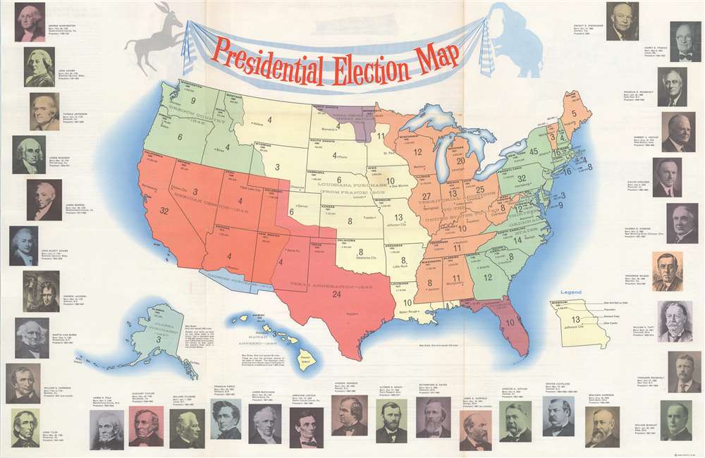
Presidential Election Map.
1960 (undated) 20.5 x 31 in (52.07 x 78.74 cm) 1 : 8976000
1960 (undated) 20.5 x 31 in (52.07 x 78.74 cm) 1 : 8976000
Description
A scarce map of the United States explaining the electoral college for the 1960 Presidential Election - Kennedy (D) vs. Nixon (R). The number of electoral votes up for grabs in each state is noted. Additional information appears in the upper left portion of each one state, including each state's name, the date it entered the Union, and its 1960 population. The whole is bordered on three sides by portraits of the presidents, from George Washington to the then-sitting president, Dwight D. Eisenhower.
1960 Presidential Election
The 1960 Presidential Election pitted Democrat John F. Kennedy against Republican Richard Nixon. This was the first election in which fifty states participated and the last in which the District of Columbia did not, marking the first participation of Alaska and Hawaii. Kennedy won a 303 to 219 Electoral College victory, which was the closest since 1916. It is also one of the first elections where the losing side, in this case the Republican ticket, declared, against all evidence, that the election was swayed by fraud.United States Territorial Expansion
This map also chronicles U.S. territorial expansion with land purchases, cessions, and annexations noted. Modern state boundaries do not always align with the frontiers of these acquisitions.Verso Content
Further educational content concerning American government and elections fills the verso. On the upper left, a map of the United States illustrates how the electoral college voted in 1956. Just below that is a table one could fill out to track the voting returns of the 1960 elections. In the center, a graphic explains the separation of powers and the checks and balances provided for in the U.S. Constitution. This graphic also delineates how the executive, legislative, and judicial branches are divided in addition to the Cabinet. A short text about presidential succession and the history of the Democratic and Republican parties occupies the center, and below that is a table dedicated to the details of the offices of the executive, legislative, and judicial branches of the federal government. A short text explaining the electoral college is included on the right next to a chronological list of U.S. presidents.Publication History and Census
This map was created and published by Rand McNally c. 1960. An example is part of the Kathleen Morrow Watley Collection at The Sixth Floor Museum at Dealey Plaza in Dallas, Texas. Four examples are cataloged in OCLC and are part of the collections at the Osher Map Library at the University of Southern Maine, the University of Michigan, the University of Chicago, and the University of Minnesota, Minneapolis.Cartographer
Rand, McNally and Co. (fl. 1856 - present) is an American publisher of maps, atlases and globes. The company was founded in 1856 when William H. Rand, a native of Quincy, Massachusetts, opened a print shop in Chicago. Rand hired the recent Irish immigrant Andrew McNally to assist in the shop giving him a wage of 9 USD per week. The duo landed several important contracts, including the Tribune's (later renamed the Chicago Tribune) printing operation. In 1872, Rand McNally produced its first map, a railroad guide, using a new cost effective printing technique known as wax process engraving. As Chicago developed as a railway hub, the Rand firm, now incorporated as Rand McNally, began producing a wide array of railroad maps and guides. Over time, the firm expanded into atlases, globes, educational material, and general literature. By embracing the wax engraving process, Rand McNally was able to dominate the map and atlas market, pushing more traditional American lithographic publishers like Colton, Johnson, and Mitchell out of business. Eventually Rand McNally opened an annex office in New York City headed by Caleb S. Hammond, whose name is today synonymous with maps and atlases, and who later started his own map company, C. S. Hammond & Co. Both firms remain in business. More by this mapmaker...
Condition
Very good. Exhibits light wear along original fold lines. Exhibits light toning.
References
OCLC 58872399.