This item has been sold, but you can get on the Waitlist to be notified if another example becomes available, or purchase a digital scan.
1770 Delisle de Sales Navigation Map of the Primitive World
PrimitivWorldNavigation-sales-1770$125.00

Title
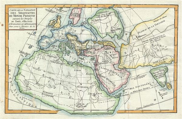
Carte de la Navigation des Argonautes du monde Primitif suivant les periples de Timee, d'Hecatee, d'Apollonius et d'Onomacrite Pour servir a l'Histoire de la Greece.
1770 (undated) 9 x 13.5 in (22.86 x 34.29 cm)
1770 (undated) 9 x 13.5 in (22.86 x 34.29 cm)
Description
This is a fascinating example of Jean-Baptiste-Claude Delisle de Sales' map 1770 of the Ancient World. Is as much as it was understood by ancient Greek Geographicus, Delisle de Sales' map depicts the entire world and follows the journeys of the historians and philosophers Timaeus, Hecataeus, Apollonius and Onomacritus. While Africa, Western Europe, and Arabia are recognizable, what are today Russia, Asia, and the Indian subcontinent are separated from one another by wide oceanic channels. Western exploration had yet to reach Asia's northeast coast and consequently a conjectural rounded coastline is shown. Scythia is depicted as a separate continent in itself, while central Italy, identified by its Greek name Thyrrenia, is a separate island. The Island of Nova Zembla or Novaya Zemlya is here identified as Island Tazata (or Tasata, its primitive name, from the River Taas). In Africa. the Mountains of the Moon as well as the speculative lakes at the source of the Nile River are identified. Sri Lanka or Ceylon is identified by its Roman name, Tapobrana. Several ancient cities and towns are named, including Ecbatane, Babylon, Berenice, and others. This map was issued as part of Delisle de Sales' Histoire des hommes. Partie de l'Histoire Ancienne. Becasue most of Sales' work was burnt under the censorship of heresy, this volume is exceedingly rare.
Cartographer
Jean-Baptiste-Claude Delisle de Sales or Jean-Baptiste Isoard de Lisle (1741–1816) was a French philosopher, historian, and accused heretic active in the late 18th century. Sales is best known for his publication of the multi-volume opus The Philosophy of Nature: Treatise on Human Moral Nature. The work, among other ideas, challenged the Biblical theory that the earth was created in 4004 BC. Instead, Sales put forth the theory based upon astronomical observations, that the earth was 140,000 years old. Sales' revolutionary ideas caused him to be declared a heretic by the Catholic Church. His publications were subsequently censored and, for the most part, destroyed. As a consequence all of his works are today extremely rare. Sales was also, notably, a close friend of Voltaire who in 1777 visited him in prison, gifting him 500 pounds towards his release. Delisle de Sales is unrelated to the more famous De L'Isle family of cartographers. More by this mapmaker...
Source
Delisle de Sales, Histoire des Hommes. Partie de l'Histoire Ancienne (Paris) 1770.
Condition
Very good. Blank on verso. Minor wear along original foldlines. Minor damage and verso repair near lower left quadrant.