This item has been sold, but you can get on the Waitlist to be notified if another example becomes available, or purchase a digital scan.
1864 Admiralty Nautical Chart or Map of Prince Edward Island, Canada
PrinceEdward-admiralty-1864$150.00

Title
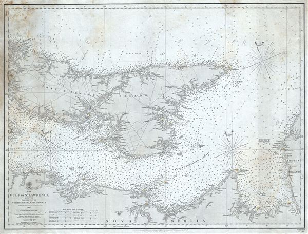
The Gulf of St. Lawrence Sheet IX Eastern part of Northumberland Strait.
1851 (dated) 19.5 x 25.5 in (49.53 x 64.77 cm) 1 : 290000
1851 (dated) 19.5 x 25.5 in (49.53 x 64.77 cm) 1 : 290000
Description
This is a scarce 1864 British Admiralty Hydrographic Office maritime map or nautical chart of Prince Edward Island and vicinity. Centered on Prince Edward Island, Canada's smallest maritime province, it covers the eastern part of the Island as well as the Gulf of St. Lawrence, the eastern part of the Northumberland Strait and the northern portion of Nova Scotia. The chart features both nautical and inland details noting topographical features and thousands of depth soundings (in fathoms). Important ports, rivers, reefs, light houses, and navigational points are carefully noted. This map, based on the survey work conducted by Captain H. W. Bayfield F. A. S., was first issued in 1851, with corrections up to December 1864.
Although Prince Edward Island did not enter the Canadian Confederation until 1873, it is known as the 'Birthplace of Confederation.' The Charlottetown Conference, which took place in September 1864, just three months before this chart was issued, was the first meeting in the process of establishing the British North America Confederation or the Dominion of Canada. Charlottetown is identified on this chart.
The map is engraved by J. and C. Walker and published according to Act of Parliament at the Hydrographic Office of the Admiralty, and sold by J. D. Potter, Agent for the Admiralty Charts. The verso of the chart includes a label for a subsequent seller, A. and H. Creichton, Stationers, dealers in charts, navigation books, etc.
Cartographer
The British Admiralty Office (1795 - Present) or the United Kingdom Hydrographic Office refers to the Branch of the English government that is responsible for the command of the British Navy. In 1795 King George III created the United Kingdom Hydrographic Office, known in short as the U.K.H.O., to provide top notch nautical charts to the vast Royal Navy. Prior the founding of the Admiralty the surveying and creation of nautical charts was primarily a commercial venture wherein the cartographer himself, more of than not, actually financed the printing of his own material. The great navigator Cook himself is known to have scrambled for funds to publish his own seminal charts - the most important and advanced of the period. The system of privately funded nautical mapping and publishing left vast portions of the world uncharted and many excellent charts unpublished. King George III, responding significant loss in trade revenue related to shipwrecks and delay due to poor charts, recognized the need for an institutionalized government sponsored cartographic agency - the Admiralty. The first head of the Admiralty, a position known as Hydrographer, was the important cartographer Alexander Dalrymple. Dalrymple started by organizing and cataloging obtainable charts before initiating the laborious process of updating them and filling in the blanks. The first official Admiralty Chart appeared in 1800 and detailed Quiberon Bay in Brittany. By 1808 the position of Hydrographer fell to Captain Thomas Hurd. Hurd advocated the sale of Admiralty charts to the general public and, by the time he retired in 1829, had issued and published some 736 charts. Stewardship of the organization then passed to Rear Admiral Sir Francis Beaufort. It was under Beaufort's administration that the Admiralty truly developed as a "chart making" as opposed to a "chart cataloging" institution. Beaufort held his post from 1829 to 1854. In his 25 years at the Admiralty Beaufort created nearly 1500 new charts and sponsored countless surveying and scientific expeditions - including the 1831 to 1836 voyage of the H.M.S. Beagle. By 1855 the Admiralty's chart catalog listed some 1,981 charts. More by this mapmaker...
Condition
Very good. Overall toning. Some spotting near left margin.