This item has been sold, but you can get on the Waitlist to be notified if another example becomes available, or purchase a digital scan.
1751 D'Anville Map of Ecuador and Peru
ProvinceQuito-anville-1751$225.00

Title
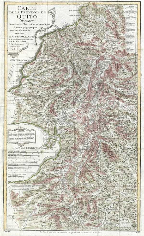
Carte de la Province de Quito au Perou. Dressée sur les observations astronomiques, mesure géographiques, journaux de route et mémoires de Mr. de Condamine et sur ceux de Don Pedro Maldonado.
1751 (dated) 24 x 15 in (60.96 x 38.1 cm) 1 : 1235000
1751 (dated) 24 x 15 in (60.96 x 38.1 cm) 1 : 1235000
Description
This is a 1751 Charles Marie de la Condamine and Jean-Baptiste Bourguinon d'Anville map of Ecuador and Peru. This map details, with incredible precision, the area which the Spanish called the Province of Quito, which covers parts of modern day Colombia, Ecuador, and Peru. The map stretches from Barbacoas, Colombia in the north, south past Quito and Guayaquil, Ecuador, into central Peru, and from the Pacific coast into the interior, which d'Anville considered 'impassable and unknowable woods and forests.' It includes the Andes and innumerable rivers and streams, as well as villages, towns, and cities of varying sizes.
The purpose of this map is to present the information gathered by the Spanish-French Geodesic Mission to Ecuador, which left France in 1735. The expedition was led by Charles Marie de la Condamine, Pierre Bouguer, and Louis Godin, three French astronomers, and Jorge Juan y Santacilia and Antonio de Ulloa, who were Spanish geographers. Pedro Vicente Maldonado, an Ecuadoran geographer, joined the group in Ecuador. The purpose of the expedition was to determine the shape of the Earth: whether it was oblate (flattened at the poles, proposed by Sir Isaac Newton) or prolate (flattened near the Equator, as proposed by René Descartes). They would do so by measuring the arc of a meridian with precise triangulation surveys over three degrees of latitude – from the Equator to three degrees south, or from Quito to Cuenca. This resulted in this section of Ecuador becoming one of the most highly accurately mapped corridors of the Americas. The triangulation surveys are shown on this map.
The Spanish-French Geodesic Mission was the first truly international scientific expedition. The goal was to be able to put aside nationalist rivalries for the good of scientific exploration. Upon returning from South America, it was decided that this map, which was originally drawn by Maldonado, should be published. This was unusual, because the map was 'owned' by the Spanish government, which did not make a habit of publishing detailed maps of their possessions, in the belief that, if published, the maps could potentially aid an enemy in a war. Nevertheless, due to its scientific importance, this map was set to be published, and sent to Paris, where Condamine and d'Anville were given the task. Maldonado made the trip to Paris, but left to continue his research, and tragically passed away in 1748. Condamine and d'Anville were left to finish the map without him. Before the map could be officially printed, however, the Spanish government changed their mind, and demanded the return of all the plates and printed copies of the map. Condamine succeeded in delaying the Spanish long enough to have this plate finished and prints made, inscribing that it was published by the Imperial Academy in St. Petersburg. The other plates were changed and returned to the Spanish.
This map was drawn by Jean-Baptiste Bourguinon d'Anville, one of the most celebrated French cartographers, and engraved by Guillaume Delahaye. D'Anville was truly the first modern cartographer. Unlike many of his contemporaries and predecessors, d'Anville based his maps on intense study and research. His maps were also the most accurate and comprehensive of the period. This map was commissioned by Mr. de la Condamine to be included in his Journal du voyage fait par ordre du roi à l'équateur, servant d'introduction historique à la 'Mesure des trois premiers degrés du méridien', which was published in Paris by l'Imprimerie Royale in 1751.
CartographerS
Jean Baptiste Bourguignon d'Anville (1697 - 1782) was perhaps the most important and prolific cartographer of the 18th century. D'Anville's passion for cartography manifested during his school years when he amused himself by composing maps for Latin texts. There is a preserved manuscript dating to 1712, Graecia Vetus, which may be his earliest surviving map - he was only 15 when he drew it. He would retain an interest in the cartography of antiquity throughout his long career and published numerous atlases to focusing on the ancient world. At twenty-two D'Anville, sponsored by the Duke of Orleans, was appointed Geographer to the King of France. As both a cartographer and a geographer, he instituted a reform in the general practice of cartography. Unlike most period cartographers, D'Anville did not rely exclusively on earlier maps to inform his work, rather he based his maps on intense study and research. His maps were thus the most accurate and comprehensive of his period - truly the first modern maps. Thomas Basset and Philip Porter write: "It was because of D'Anville's resolve to depict only those features which could be proven to be true that his maps are often said to represent a scientific reformation in cartography." (The Journal of African History, Vol. 32, No. 3 (1991), pp. 367-413). In 1754, when D'Anville turned 57 and had reached the height of his career, he was elected to the Academie des Inscriptions. Later, at 76, following the death of Philippe Buache, D'Anville was appointed to both of the coveted positions Buache held: Premier Geographe du Roi, and Adjoint-Geographer of the Academie des Sciences. During his long career D'Anville published some 211 maps as well as 78 treatises on geography. D'Anville's vast reference library, consisting of over 9000 volumes, was acquired by the French government in 1779 and became the basis of the Depot Geographique - though D'Anville retained physical possession his death in 1782. Remarkably almost all of D'Anville's maps were produced by his own hand. His published maps, most of which were engraved by Guillaume de la Haye, are known to be near exact reproductions of D'Anville' manuscripts. The borders as well as the decorative cartouche work present on many of his maps were produced by his brother Hubert-Francois Bourguignon Gravelot. The work of D'Anville thus marked a transitional point in the history of cartography and opened the way to the maps of English cartographers Cary, Thomson and Pinkerton in the early 19th century. More by this mapmaker...
Guillaume-Nicolas Delahaye (1725 - February 24, 1802) was the most prolific member of the Delahaye (De-La-Haye) family of engravers active in Paris throughout the 18th century. Given that the name, Delahaye literally translates to 'of the Hague' it can be assume they were French Huguenots who were forced to flee the Netherlands under threat of religious persecution. Born in Paris, he was the son of patriarch Jean-Baptiste Delahaye and brother to Jean-Baptistie-Henri Delahaye. It is said that his godfather, who held him at the baptismal font, was none other than the famous french cartographer Guillaume de L'Isle. The Delahaye family engraved for many of the great cartographers of 18th century Paris, including Jean-Baptiste Bourguignon d'Anville, Didier Robert de Vaugondy, Jean-Baptiste de Mannevillette, and Jean-Nicolas Buache, among others. He was awarded the public office Premier Graveur du Roi and worked on a series of maps illustrating the king's hunts around Versailles. Guillaume also worked with foreign cartographers such as Tomas Lopez of Madrid. Possibly Delahaye's most significant map is A Map of the Country between Albemarle Sound and Lake Erie prepared for the memories of Thomas Jefferson. He married in 1758. In total he engraved some 1200 maps. Delahaye died in Charenton. In 1792, his daughter, Antoinette Marie Delahaye (1773-1857), married the geographer Jean-Denis Barbie du Bocage. Learn More...
Source
La Condamine, Charles Marie de, Journal du voyage fait par ordre du roi à l'équateur, servant d'introduction historique à la 'Mesure des trois premiers degrés du méridien' (Paris: l'Imprimerie Royale), 1751.
Condition
Very good. Blank on verso.
References
OCLC 762244945.