This item has been sold, but you can get on the Waitlist to be notified if another example becomes available, or purchase a digital scan.
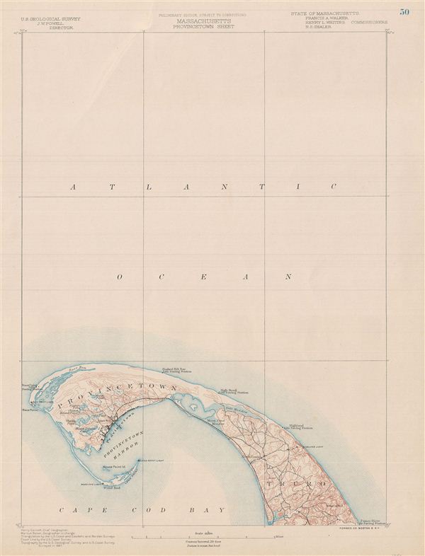
1887 U.S. Geological Survey Map of Provincetown, Cape Cod, Massachusetts
Provincetown-usgs-1887$125.00

Title
Massachusetts Provincetown Sheet.
1887 (dated) 14 x 20 in (35.56 x 50.8 cm)
1887 (dated) 14 x 20 in (35.56 x 50.8 cm)
Description
A fine first edition example of the 1887 U.S. Geological Survey's map Cape Cod, Massachusetts. Covers from Gull Pamet River and Smalls Hill north along the cape as far as Provincetown Harbor and Race Point. Offers typical superb detail throughout noting topographical features, rail lines, light houses, marsh lands, and numerous individual buildings. Notes the Pamet River Life Saving Stations, the Highland light and life saving station, the High Head Life Saving Station, the Peaked Hill Bar Life Saving Station, the Race Point Light and Life Saving Station, the Wood end Light, and the Long Point Light.
Cartographer
The Office of the Coast Survey (later the U.S. Geodetic Survey) (1807 - present), founded in 1807 by President Thomas Jefferson and Secretary of Commerce Albert Gallatin, is the oldest scientific organization in the U.S. Federal Government. Jefferson created the "Survey of the Coast," as it was then called, in response to a need for accurate navigational charts of the new nation's coasts and harbors. The first superintendent of the Coast Survey was Swiss immigrant and West Point mathematics professor Ferdinand Hassler. Under the direction of Hassler, from 1816 to 1843, the ideological and scientific foundations for the Coast Survey were established. Hassler, and the Coast Survey under him developed a reputation for uncompromising dedication to the principles of accuracy and excellence. Hassler lead the Coast Survey until his death in 1843, at which time Alexander Dallas Bache, a great-grandson of Benjamin Franklin, took the helm. Under the leadership A. D. Bache, the Coast Survey did most of its most important work. During his Superintendence, from 1843 to 1865, Bache was steadfast advocate of American science and navigation and in fact founded the American Academy of Sciences. Bache was succeeded by Benjamin Pierce who ran the Survey from 1867 to 1874. Pierce was in turn succeeded by Carlile Pollock Patterson who was Superintendent from 1874 to 1881. In 1878, under Patterson's superintendence, the U.S. Coast Survey was reorganized as the U.S. Coast and Geodetic Survey (C & GS or USGS) to accommodate topographic as well as nautical surveys. Today the Coast Survey is part of the National Oceanic and Atmospheric Administration or NOAA. More by this mapmaker...
Condition
Very good. Minor crease upper left quadrant. Blank on verso.