1710 Homann Map of the Kingdom of Prussia
Prussia-homann-1710$600.00
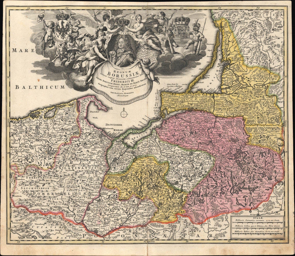

Title
Regnum Borussiae: Gloriosis auspicÿs Serenissimi et Potentissimi Prin Friderici III. Primi Borussiae Regis, March. et Elect. Bran. inauguratum die 18. Ian. A. 1701. Geographice cum vicinis Regionibus adumbratum a Ioh. Baptista Homanno Norimbergae.
1710 (undated) 19 x 22.75 in (48.26 x 57.785 cm) 1 : 730000
1710 (undated) 19 x 22.75 in (48.26 x 57.785 cm) 1 : 730000
Description
This is first edition Johann Baptist Homann's c. 1710 map of the Kingdom of Prussia, produced to commemorate the day (January 18, 1701) on which Elector Friedrich III of Brandenburg crowned himself King Friedrich I in Prussia in Königsberg. The map displays the borders of the Kingdom of Prussia at its inception and presents a portrait of the new king framed by an ornate allegorical cartouche.
More tangibly, Prussia's neighborhood was transformed by the Great Northern War (1700 - 1721), which saw Swedish power in northeastern Europe recede and Russia's increase. Joining the war in its latter years, Prussia gained territory and developed a strong emphasis on administrative and military modernization, led by Crown Prince and then King Frederick William I (r. 1713 - 1740). His son, Frederick II ('Frederick the Great,' r. 1740 - 1786), was the embodiment of a philosopher-king, a brilliant military strategist, and an ally of the Enlightenment. By the end of his reign, Prussia had significantly expanded its territory and was one of the leading powers in Europe.
A Closer Look
The map reaches from the Baltic Sea to as far south as Toruń (Thorn) on the Vistula River and spans from the Duchy of Pomerania in the west to part of the Duchy of Samogitia in the east (today's Lithuania). The region here marked Prussiae Regnum constituted Eastern Prussia; this includes what is now the Kaliningrad Oblast of Russia and the northeastern portions of Poland ('Prussia Polonica'). These are divided on the map into the regions Circulus Hockerlandiae, Circulus Natangiensis, and Circul Sambiensis. The map also includes the Pomeranian Voivodeship and the regions of Mirachowo, Puck, Człuchów, Świecie, Tuchola, Żukowo, Chełmno Voivodeship, Michałowo, and the Malbork Voivodeship.A Baroque Allegorical Cartouche
The Baltic Sea is filled with an elaborate cartouche teeming with imagery. It is centered on a portrait of Frederick III, the Electorate of Brandenburg and King in Prussia; his motto 'Suum Cuique' appears at his head. To the left, a quartet of putti support the arms of the Kingdom of Prussia; at the right, with its attendant cudgel-bearing, helmeted putti are the arms of the Prince-Elector of Brandenberg. To the right of Frederick's portrait is a map representing the Electorate of Brandenberg in Germany, which remained his domain and would be the western part of the new Kingdom of Prussia. The new king is here attended on the left by Minerva (goddess of wisdom-in-war); Hermes (messenger of the gods and patron of commerce) hovers to the right. Above Frederick, a crown is suspended jointly between the allegories of Fame and Modesty.The Emergence of Prussian Power
Given the kingdom's subsequent importance and even centrality to German history, the historical origins of Prussia are surprisingly modest. The territory began as a relatively poor and unimportant duchy in vassalage to the Polish crown in the 16th century. It began to take shape under the leadership of the Hohenzollern family, Electors of Brandenberg, who inherited the duchy in 1618 and gained its sovereignty in the Second Northern War (1665 - 1660). Prussia's status as a rising power was confirmed in the early 18th century when it was allowed to elevate itself to a kingdom and Frederick to become 'King in Prussia' (not 'King of Prussia'). This specific terminology was a loophole, circumventing the restriction on kingdoms within the Holy Roman Empire, created by Emperor Leopold I (r. 1658 - 1705) to secure Prussia's support in the War of the Spanish Succession (1701 - 1715). Although Prussia was outside of the Holy Roman Empire, Brandenburg was within it; thus, the Hohenzollern rulers operated with two separate titles until the end of the Holy Roman Empire during the Napoleonic Wars.More tangibly, Prussia's neighborhood was transformed by the Great Northern War (1700 - 1721), which saw Swedish power in northeastern Europe recede and Russia's increase. Joining the war in its latter years, Prussia gained territory and developed a strong emphasis on administrative and military modernization, led by Crown Prince and then King Frederick William I (r. 1713 - 1740). His son, Frederick II ('Frederick the Great,' r. 1740 - 1786), was the embodiment of a philosopher-king, a brilliant military strategist, and an ally of the Enlightenment. By the end of his reign, Prussia had significantly expanded its territory and was one of the leading powers in Europe.
Publication History and Census
This map's printing history is convoluted. We have identified this map in no fewer than six separate plates engraved during the 18th century, either by Homann or his heirs. The present example is from the first of these, engraved as early as 1707 and appearing in Homann atlases dated 1710 and 1716. The differences between this first plate and the second (also sold by us as Prussia-homann-1730) are less pronounced than those with later plates but still noticeable, particularly in Frederick's portrait, the faces of the gods and putti in the cartouche, and in other small differences, such as three small circles at the cardinal direction east in the compass rose below the title here. The David Rumsey Historical Map Collection holds a highly similar example from a c. 1716 composite atlas, though there are slight differences with the present map, which can be seen in minor details, such as the coats of arms in the cartouche. In any event, the present example lacks Homann's privilege, which was added to later printings, indicating a date before 1715. The map appears to be well-represented in institutional collections in its various iterations, but it is difficult to determine the distribution of specific versions from catalog listings. It appears on the market from time to time but less often in this earliest state.Cartographer
Johann Baptist Homann (March 20, 1664 - July 1, 1724) was the most prominent and prolific map publisher of the 18th century. Homann was born in Oberkammlach, a small town near Kammlach, Bavaria, Germany. As a young man, Homann studied in a Jesuit school and nursed ambitions of becoming a Dominican priest. Nonetheless, he converted to Protestantism in 1687, when he was 23. It is not clear where he mastered engraving, but we believe it may have been in Amsterdam. Homann's earliest work we have identified is about 1689, and already exhibits a high degree of mastery. Around 1691, Homann moved to Nuremberg and registered as a notary. By this time, he was already making maps, and very good ones at that. He produced a map of the environs of Nürnberg in 1691/92, which suggests he was already a master engraver. Around 1693, Homann briefly relocated to Vienna, where he lived and studied printing and copper plate engraving until 1695. Until 1702, he worked in Nuremberg in the map trade under Jacob von Sandrart (1630 - 1708) and then David Funck (1642 - 1709). Afterward, he returned to Nuremberg, where, in 1702, he founded the commercial publishing firm that would bear his name. In the next five years, Homann produced hundreds of maps and developed a distinctive style characterized by heavy, detailed engraving, elaborate allegorical cartouche work, and vivid hand color. Due to the lower cost of printing in Germany, the Homann firm could undercut the dominant French and Dutch publishing houses while matching their diversity and quality. Despite copious output, Homann did not release his first major atlas until the 33-map Neuer Atlas of 1707, followed by a 60-map edition of 1710. By 1715, Homann's rising star caught the attention of the Holy Roman Emperor Charles VI, who appointed him Imperial Cartographer. In the same year, he was also appointed a member of the Royal Academy of Sciences in Berlin. Homann's prestigious title came with several significant advantages, including access to the most up-to-date cartographic information as well as the 'Privilege'. The Privilege was a type of early copyright offered to very few by the Holy Roman Emperor. Though less sophisticated than modern copyright legislation, the Privilege offered limited protection for several years. Most all J. B. Homann maps printed between 1715 and 1730 bear the inscription 'Cum Priviligio' or some variation. Following Homann's death in 1724, the firm's map plates and management passed to his son, Johann Christoph Homann (1703 - 1730). J. C. Homann, perhaps realizing that he would not long survive his father, stipulated in his will that the company would be inherited by his two head managers, Johann Georg Ebersberger (1695 - 1760) and Johann Michael Franz (1700 - 1761), and that it would publish only under the name 'Homann Heirs'. This designation, in various forms (Homannsche Heirs, Heritiers de Homann, Lat Homannianos Herod, Homannschen Erben, etc.) appears on maps from about 1731 onwards. The firm continued to publish maps in ever-diminishing quantities until the death of its last owner, Christoph Franz Fembo (1781 - 1848). More by this mapmaker...
Source
Homann, J. B., Neuer Atlas bestehend in einig curieusen Astronomischen Kuppren und vielen auserlesenen accuratensten Land-Charten über die Gantze Welt, (Nuremberg: Homann) 1710.
Homann's Neuer Atlas bestehend in einig curieusen Astronomischen Kuppren und vielen auserlesenen accuratensten Land-Charten über die Gantze Welt was first publihsed in 1707 with 33 maps. A second edition followed in 1710 with 60 maps. Subsequent editions followed until about 1730. The title page notes proudly that the atlas features measurements based on the 'Copernican principle of the moving sky', a truly state-of-the-art innovation for the period. Regardless of editions, collations of the atlas are inconsistent, with some examples having less, while others have more maps - a consequence of the fact that the map sheets were delivered loose, to be bound at the buyer's discretion, and so some buyers chose to omit maps they did not consider relevant, or add others they did. Between editions, the constituent maps, particularly of European regions, were regularly updated to reflect the most recent political events. The atlas continued to be published by Homann's son, J. C. Homann (1703 - 1730), and then by Homann Heirs. Most examples also feature a fine allegorical frontispiece with the title Atlas Novus Terrarum Orbis Imperia, regna et Status, which was used for multiple Homann atlases, including the Neuer Atlas and the Atlas Minor.
Condition
Very good. Light wear and discoloration along centerfold, mostly confined to bottom margin. Some soiling in bottom-right margin.
References
OCLC 315375414. Rumsey 12499.159 (c. 1716 printing).